File:Stružinec, CZ171017-034.jpg
Jump to navigation
Jump to search

Size of this preview: 800 × 448 pixels. Other resolutions: 320 × 179 pixels | 640 × 359 pixels | 1,024 × 574 pixels | 1,280 × 718 pixels | 2,560 × 1,435 pixels | 4,759 × 2,668 pixels.
Original file (4,759 × 2,668 pixels, file size: 4.4 MB, MIME type: image/jpeg)
Captions
Captions
Add a one-line explanation of what this file represents
Summary
[edit]
| Description |
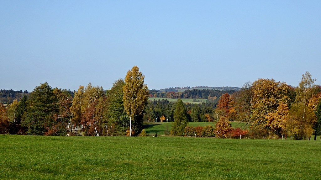
English: "Stružinec" is a hamlet lying on a slope north-northwest of the summit "Barchanec" (624 m above sea level), in the geomorphological district with name "Stružinecká" knoll hill. The constructions is hidden in the notch of the terrain under the tall trees, in the locality of the source of the no name brook and several small ponds. In the hamlet there are six monument protected trees (five linden and one elm). From the pastures above the hamlet "Stružinec", under of the locality with name "Bewitched Glade", view of the landscape of the Iron Mountains. The highest peak with geographical name "Vestec" (668 m) in the Protected Landscape Area Iron Mountains is also good visible – in the photo on the horizon right. Photo location: Czechia, Vysočina Region, town Ždírec nad Doubravou, "Stružinec" – settlement locality.
Note:Čeština: Stružinec je vesnička ležící na svahu severo-severozápadně od vrcholu Barchanec (624 m n. m.), v geomorfologickém okrsku s názvem Stružinecká pahorkatina. Zástavba je skryta v zářezu terénu pod vzrostlými stromy, v lokalitě pramene bezejmenného potoka a několika malých rybníčků. Ve vesničce roste šest památkově chráněných stromů (pět lip srdčitých a jeden jilm horský). Z pastvin nad Stružincem, pod lokalitou s názvem Očarovaný palouk, rozhled do krajiny Železných hor. Nejvyšší vrchol se zeměpisným názvem Vestec (668 m n. m.) v Chráněné krajinné oblasti Železné hory je také dobře viditelný – na fotografii na horizontu vpravo. Foto lokace: Česko, Kraj Vysočina, vesnice Stružinec (290°).
Poznámka: |
| Date | |
| Source | Own work |
| Author | Josef Kreuz (PEPan) |
| Camera location | | View this and other nearby images on: OpenStreetMap |
|---|
Externí odkazy
[edit]
- Turistická mapa – kompozice Stružinec a okolí, letecký pohled viz
- Stružinec – heslo CS Wikipedie viz
- Stružinecká pahorkatina – heslo CS Wikipedie viz
Licensing
[edit]
I, the copyright holder of this work, hereby publish it under the following license:
This file is licensed under the Creative Commons Attribution-Share Alike 4.0 International license.
- You are free:
- to share – to copy, distribute and transmit the work
- to remix – to adapt the work
- Under the following conditions:
- attribution – You must give appropriate credit, provide a link to the license, and indicate if changes were made. You may do so in any reasonable manner, but not in any way that suggests the licensor endorses you or your use.
- share alike – If you remix, transform, or build upon the material, you must distribute your contributions under the same or compatible license as the original.
File history
Click on a date/time to view the file as it appeared at that time.
| Date/Time | Thumbnail | Dimensions | User | Comment | |
|---|---|---|---|---|---|
| current | 14:26, 15 December 2017 | | 4,759 × 2,668 (4.4 MB) | PEPan (talk | contribs) | User created page with UploadWizard |
You cannot overwrite this file.
File usage on Commons
There are no pages that use this file.
File usage on other wikis
The following other wikis use this file:
- Usage on cs.wikipedia.org