File:Strikezone.png
Jump to navigation
Jump to search
No higher resolution available.
Strikezone.png (600 × 500 pixels, file size: 9 KB, MIME type: image/png)
Captions
Captions
Add a one-line explanation of what this file represents
Summary
[edit]
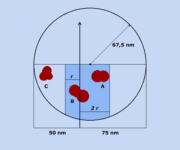
| Description | A: direct hit (not landfall), B: landfall, C: indirect hit/strike. An example for case A was Hurricane Ophelia in 2005 in North Carolina (northwest eyewall hit the Outer Banks but the eye center remained over water). An example for case C was Hurricane Rita in southern Florida and Cuba. (The "impact" area often goes far beyond that diagram as it also includes the areas impacted by tropical storm-force winds, as well as heavy rain, surf or tornadoes beyond the wind radius.) |
| Date | |
| Source | Own work |
| Author | Matthiasb |
Licensing
[edit]
| I, the copyright holder of this work, release this work into the public domain. This applies worldwide. In some countries this may not be legally possible; if so: I grant anyone the right to use this work for any purpose, without any conditions, unless such conditions are required by law. |
File history
Click on a date/time to view the file as it appeared at that time.
| Date/Time | Thumbnail | Dimensions | User | Comment | |
|---|---|---|---|---|---|
| current | 11:24, 16 October 2007 | | 600 × 500 (9 KB) | Matthiasb (talk | contribs) | Modified |
| 16:11, 15 October 2007 |  | 600 × 500 (8 KB) | Matthiasb (talk | contribs) | {{Information |Description= |Source=self-made |Date=15-10-2007 |Author= Matthiasb }} |
You cannot overwrite this file.
File usage on Commons
There are no pages that use this file.
File usage on other wikis
The following other wikis use this file:
- Usage on de.wikipedia.org
- Usage on en.wikipedia.org