File:Streckenkarte der Stettiner Bahn.png
Jump to navigation
Jump to search

Size of this preview: 536 × 599 pixels. Other resolutions: 215 × 240 pixels | 429 × 480 pixels | 687 × 768 pixels | 916 × 1,024 pixels | 1,732 × 1,936 pixels.
Original file (1,732 × 1,936 pixels, file size: 1.87 MB, MIME type: image/png)
Captions
Captions
Add a one-line explanation of what this file represents
| Description |
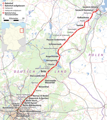
Deutsch: Streckenkarte der Stettiner Bahn |
| Date | see file history |
| Source |
Own work, using
|
| Author | Maximilian Dörrbecker (Chumwa) |
| Permission (Reusing this file) |
All OpenStreetMap data and maps are Creative Commons "CC-BY-SA 2.0" licensed This file is licensed under the Creative Commons Attribution-Share Alike 2.0 Generic license.
|
File history
Click on a date/time to view the file as it appeared at that time.
| Date/Time | Thumbnail | Dimensions | User | Comment | |
|---|---|---|---|---|---|
| current | 18:35, 13 April 2010 | | 1,732 × 1,936 (1.87 MB) | Chumwa (talk | contribs) | Hinweis auf ehem. Bahnhof Chorin Kloster gesetzt |
| 19:34, 11 April 2010 |  | 1,732 × 1,936 (1.87 MB) | Chumwa (talk | contribs) | Haltepunkt Rosow nachgetragen | |
| 08:00, 5 April 2010 |  | 1,732 × 1,936 (1.87 MB) | Chumwa (talk | contribs) | {{Information |Description={{de|Streckenkarte der Stettiner Bahn}} |Author=Maximilian Dörrbecker (Chumwa) |Source={own}, using * OpenStreetMap data for the background * [[:File:Germany_location_map.svg|this fil |
You cannot overwrite this file.
File usage on Commons
The following 2 pages use this file:
File usage on other wikis
The following other wikis use this file:
- Usage on de.wikipedia.org
- Usage on en.wikipedia.org
- Usage on fr.wikipedia.org
- Usage on ja.wikipedia.org
- Usage on ko.wikipedia.org
- Usage on no.wikipedia.org
- Usage on pl.wikipedia.org
- Usage on www.wikidata.org