File:StraubePlan1910 Bereich Andreasstraße.jpg
Jump to navigation
Jump to search

Size of this preview: 800 × 456 pixels. Other resolutions: 320 × 182 pixels | 640 × 365 pixels | 1,024 × 583 pixels | 1,580 × 900 pixels.
Original file (1,580 × 900 pixels, file size: 894 KB, MIME type: image/jpeg)
Captions
Captions
Add a one-line explanation of what this file represents
Summary
[edit]
| Description |
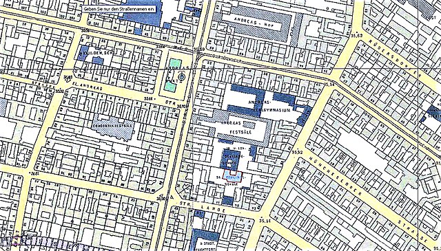
Deutsch: Die Andreasstraße ist ein Straße im Berliner Bezirk Friedrichshain-Kreuzberg, Ortsteil Friedrichshain zwischen Holzmarkstraße/ Stralauer Platz (nahe Ostbahnhof) und der Karl-Marx-Allee. Das Bild als Ausschnitt des Straube-Plans von 1910 zeigt den damaligen Zustand von Wohnbebauung und Gewerbe- und Schulflächen im Innenblock zwischen Andreas- und Koppenstraße und westwärts zwischen Andreas- und Krautstraße |
| Date | (2010) |
| Source | Bildschirmscan der Straubeplan IIB 1910 von Histomap-Berlin (Boonekamp d.i.Günter Haasenachgearbeitet: Färbung und Kontrast angepasst) |
| Author | Geoportal Berlin K4 2012 |
Mittelpunkt:
| Camera location | | View this and other nearby images on: OpenStreetMap |
|---|
Licensing
[edit]

|
The copyright holder of this work allows anyone to use it for any purpose including unrestricted redistribution, commercial use, and modification.
Usage notes:
|
File history
Click on a date/time to view the file as it appeared at that time.
| Date/Time | Thumbnail | Dimensions | User | Comment | |
|---|---|---|---|---|---|
| current | 08:43, 27 August 2017 | | 1,580 × 900 (894 KB) | Boonekamp (talk | contribs) | {{Information |Description ={{de|1=Die Andreasstraße ist ein Straße im Berliner Bezirk Friedrichshain-Kreuzberg, Ortsteil Friedrichshain zwischen Holzmarkstraße/ Stralauer Platz (nahe Ostbahnhof) und der Karl-Marx-Allee. Das Bild als Ausschnitt d... |
You cannot overwrite this file.
File usage on Commons
There are no pages that use this file.
File usage on other wikis
The following other wikis use this file:
- Usage on de.wikipedia.org
Metadata
Categories:
- Andreasstraße (Berlin-Friedrichshain)
- Koppenstraße (Berlin-Friedrichshain)
- Krautstraße (Berlin-Friedrichshain)
- Singerstraße (Berlin-Friedrichshain)
- Lange Straße (Berlin-Friedrichshain)
- Kleine Andreasstraße (Berlin-Friedrichshain)
- Übersichtsplan von Berlin (Julius Straube, 1910)
- Parts of old maps of Berlin
- Old Maps of Berlin-Friedrichshain