File:Straßenbahn-undOBusNetzentwicklungBrno.png
Jump to navigation
Jump to search

Size of this preview: 660 × 600 pixels. Other resolutions: 264 × 240 pixels | 528 × 480 pixels | 845 × 768 pixels | 1,127 × 1,024 pixels | 2,254 × 2,048 pixels | 7,302 × 6,636 pixels.
Original file (7,302 × 6,636 pixels, file size: 2.57 MB, MIME type: image/png)
Captions
Captions
Add a one-line explanation of what this file represents
Summary
[edit]
| Description |
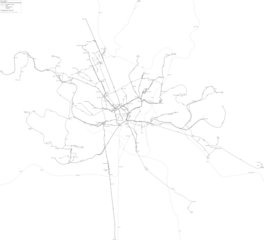
Čeština: Mapa rozvoje tramvajové a trolejbusové sítě v Brně
Deutsch: Straßenbahn- und O-Bus-Netzentwicklung Brno (Brünn) |
| Date | |
| Source | Own work |
| Author | Stef.muc |
| Permission (Reusing this file) |
This file is licensed under the Creative Commons Attribution-Share Alike 3.0 Germany license.
 |
Licensing
[edit]
I, the copyright holder of this work, hereby publish it under the following license:
This file is licensed under the Creative Commons Attribution-Share Alike 4.0 International license.
- You are free:
- to share – to copy, distribute and transmit the work
- to remix – to adapt the work
- Under the following conditions:
- attribution – You must give appropriate credit, provide a link to the license, and indicate if changes were made. You may do so in any reasonable manner, but not in any way that suggests the licensor endorses you or your use.
- share alike – If you remix, transform, or build upon the material, you must distribute your contributions under the same or compatible license as the original.
File history
Click on a date/time to view the file as it appeared at that time.
| Date/Time | Thumbnail | Dimensions | User | Comment | |
|---|---|---|---|---|---|
| current | 11:24, 28 May 2024 | | 7,302 × 6,636 (2.57 MB) | Stef.muc (talk | contribs) | Nový tunel Pisárky · neelektrifikované prodloužení trolejbusu do Soběšic |
| 00:02, 14 December 2022 |  | 7,310 × 6,164 (2.48 MB) | Stef.muc (talk | contribs) | Prodloužení tramvaje k nemocnici Bohunice a trolejbusu k Štefaníkově čtvrti, u Mendlova náměstí a (manipulačně) vedle vozovny Slatina | |
| 08:41, 16 August 2021 |  | 7,310 × 6,164 (2.43 MB) | Stef.muc (talk | contribs) | Přeložení do Komárova 2021 | |
| 14:10, 15 May 2020 |  | 7,310 × 6,164 (2.42 MB) | Stef.muc (talk | contribs) | {{Information |description ={{cs|1=Mapa rozvoje tramvajové a trolejbusové sítě v Brně}} {{de|1=Straßenbahn- und O-Bus-Netzentwicklung Brno (Brünn)}} |date =2020-05-15 |source ={{own}} |author =User:Stef.muc |permission ={{Cc-by-sa-3.0-de}} }} Category:Public transport maps of Brno |
You cannot overwrite this file.
File usage on Commons
The following 13 pages use this file:
- User:Chumwa/OgreBot/Public transport information/2020 May 11-20
- User:Chumwa/OgreBot/Public transport information/2021 August 11-20
- User:Chumwa/OgreBot/Public transport information/2022 December 11-20
- User:Chumwa/OgreBot/Public transport information/2024 May 21-31
- User:Chumwa/OgreBot/Transport Maps/2020 May 11-20
- User:Chumwa/OgreBot/Transport Maps/2021 August 11-20
- User:Chumwa/OgreBot/Transport Maps/2022 December 11-20
- User:Chumwa/OgreBot/Transport Maps/2024 May 21-31
- User:Chumwa/OgreBot/Travel and communication maps/2024 May 21-31
- Commons:WikiProject Brno/Uploads/2020 May 11-20
- Commons:WikiProject Brno/Uploads/2021 August 11-20
- Commons:WikiProject Brno/Uploads/2022 December 11-20
- Commons:WikiProject Brno/Uploads/2024 May 21-31