File:Storm in Bagram.jpg

Original file (1,024 × 633 pixels, file size: 260 KB, MIME type: image/jpeg)
Captions
Captions
Summary
[edit]
| Description |
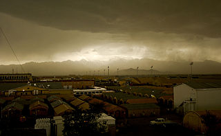
A storm rolls into Bagram Air Field, Afghanistan, April 20. The 455th Expeditionary Operations Support Squadron, combat weather team, uses a variety of techniques to predict weather. They use of a Mark IV satellite and visual reference to determine type and severity of storm to better prepare personnel on BAF to maintain mission effectiveness. Rainstorms are frequent this time of year and have the ability to change the landscape to include rivers and streams. With the lack of drainage systems, floods occur regularly throughout the southeast region of Afghanistan. Precipitation in east and southeast regions is about forty centimeters per year. 455th Air Expeditionary Wing Photo by Senior Airman Erik Cardenas Date: 04.20.2009 Location: BAGRAM AIR FIELD, AF Related photos: dvidshub.net/r/zk92xz |
| Date | Taken on 20 April 2009, 15:29 |
| Source | Storm in Bagram |
| Author | DVIDSHUB |
Licensing
[edit]
- You are free:
- to share – to copy, distribute and transmit the work
- to remix – to adapt the work
- Under the following conditions:
- attribution – You must give appropriate credit, provide a link to the license, and indicate if changes were made. You may do so in any reasonable manner, but not in any way that suggests the licensor endorses you or your use.
| This image was originally posted to Flickr by DVIDSHUB at https://www.flickr.com/photos/28650594@N03/3483547353. It was reviewed on 18 May 2009 by FlickreviewR and was confirmed to be licensed under the terms of the cc-by-2.0. |
File history
Click on a date/time to view the file as it appeared at that time.
| Date/Time | Thumbnail | Dimensions | User | Comment | |
|---|---|---|---|---|---|
| current | 20:49, 17 May 2009 | | 1,024 × 633 (260 KB) | Geo Swan (talk | contribs) | {{Information |Description= A storm rolls into Bagram Air Field, Afghanistan, April 20. The 455th Expeditionary Operations Support Squadron, combat weather team, uses a variety of techniques to predict weather. They use of a Mark IV satellite and visual r |
You cannot overwrite this file.
File usage on Commons
There are no pages that use this file.
File usage on other wikis
The following other wikis use this file:
- Usage on cs.wikipedia.org
- Usage on sk.wikipedia.org