File:Storm 91C 01 nov 2006 2030Z.jpg

Original file (6,000 × 5,600 pixels, file size: 5.91 MB, MIME type: image/jpeg)
Captions
Captions
Summary
[edit]| DescriptionStorm 91C 01 nov 2006 2030Z.jpg |
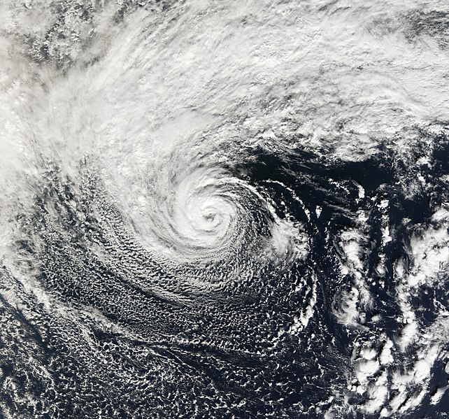
Tropical storms, as their name suggest, tend to form in the tropics. However, from time to time similar looking storms can form at higher latitudes. Extratropical storms have cold rather than warm cores and usually form their characteristic spiral shape when two fronts collide. More rare are polar lows, a similar storm system which can form in the Arctic. On very rare occasions, however, there are peculiar hybrid storms with some of the characteristics of a tropical storm and some characteristics of an extratropical storm. The terminology to describe them becomes potentially confusing. One name given to such storms is subtropical storms. This photo-like image of a subtropical storm was acquired by the Moderate Resolution Imaging Spectroradiometer (MODIS) on the Terra satellite on November 1, 2006. Located 900 miles off the coast of Oregon in the northwestern Pacific, this storm system looks like a hurricane, but it is located far from any of the typical hurricane formation areas. The storm originally formed from a cold-cored extratropical storm, but after sending two days over anomalously warm water, it developed a warm center and the hurricane characteristics of a cloud-free eye and an eyewall of thunderstorms circling the eye. Though the storm was strong enough to be named had it formed in one of the hurricane sectors, it is outside the regions which hurricane monitoring organizations administer, so the authority to give it a full name is not well defined. As of November 2, 2006, the Central Pacific Hurricane Center in Honolulu had not issued any information on the storm nor even applied it with a name. It was known merely as Storm 91C by the U.S. Navy. |
||||||
| Date | |||||||
| Source | http://earthobservatory.nasa.gov/NaturalHazards/natural_hazards_v2.php3?img_id=13951 | ||||||
| Author | NASA image by Jesse Allen, Earth Observatory, using data provided courtesy of the MODIS Rapid Response team at Goddard Space Flight Center. | ||||||
| Permission (Reusing this file) |
|
File history
Click on a date/time to view the file as it appeared at that time.
| Date/Time | Thumbnail | Dimensions | User | Comment | |
|---|---|---|---|---|---|
| current | 18:58, 2 January 2010 |  | 6,000 × 5,600 (5.91 MB) | Supportstorm (talk | contribs) | Reverted to version as of 00:19, 3 November 2006 |
| 20:41, 29 December 2009 |  | 6,000 × 5,600 (5 MB) | Supportstorm (talk | contribs) | Image Adjustment: Auto levels on contrast and color | |
| 00:19, 3 November 2006 |  | 6,000 × 5,600 (5.91 MB) | Good kitty (talk | contribs) | == Summary == {{Information |Description=Tropical storms, as their name suggest, tend to form in the tropics. However, from time to time similar looking storms can form at higher latitudes. Extratropical storms have cold rather than warm cores and usually |
You cannot overwrite this file.
File usage on Commons
The following 2 pages use this file:
File usage on other wikis
The following other wikis use this file:
- Usage on de.wikipedia.org
- Usage on en.wikipedia.org
- Usage on en.wikinews.org
- Usage on nl.wikipedia.org
- Usage on pt.wikipedia.org
- Usage on simple.wikipedia.org
- Usage on tr.wikipedia.org
- Usage on www.wikidata.org
- Usage on zh.wikipedia.org
Metadata
This file contains additional information such as Exif metadata which may have been added by the digital camera, scanner, or software program used to create or digitize it. If the file has been modified from its original state, some details such as the timestamp may not fully reflect those of the original file. The timestamp is only as accurate as the clock in the camera, and it may be completely wrong.
| _error | 0 |
|---|

