File:StoreggaTsunamiHauteurModèle Réel2005.png
Jump to navigation
Jump to search

Size of this preview: 722 × 600 pixels. Other resolutions: 289 × 240 pixels | 578 × 480 pixels | 925 × 768 pixels | 1,233 × 1,024 pixels | 1,397 × 1,160 pixels.
Original file (1,397 × 1,160 pixels, file size: 443 KB, MIME type: image/png)
Captions
Captions
Add a one-line explanation of what this file represents
Summary
[edit]
| Description |
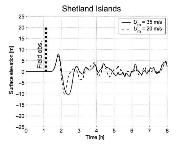
Français : Hauteur réelle (barre verticale), estimée d'après les preuves de dépôts in-situ du tsunami à "Maggie Kettles Loch" dans les îles Shetland comparée à deux modélisations de la hauteur de la crête de la vague du méga-tsunami du Storrega sur les îles Shetland basé (et variation sur quelques heures). Les deux modélisations (trait plein noir, et pointillé) sont respectivement basées sur des vitesses de glissement de 20 m/s et 35 m/s (Downson & al, en 2019 [1], d'après Bondevik et al., 2005).
English: True height (vertical bar), estimated from evidence of in-situ tsunami deposits at "Maggie Kettles Loch" in the Shetland Islands compared to two models of the wave crest height of the Storrega mega-tsunami on Shetland Islands based (and variation over a few hours). The two models (solid black line, and dotted line) are respectively based on sliding speeds of 20 m/s and 35 m/s (Downson & al, in 2019 [2], according to Bondevik et al., 2005). |
| Date | |
| Source | (en) Alastair G. Dawson et Sue Dawson, « Reconciling Storegga tsunami sedimentation patterns with modelled wave heights: A discussion from the Shetland Isles field laboratory » [archive], sur Sedimentology, avril 2020 (ISSN 0037-0746, DOI 10.1111/sed.12643, consulté le 18 février 2022), p. 1344–1353 |
| Author | Alastair G. Dawson et Sue Dawson, |
Licensing
[edit]
This file is licensed under the Creative Commons Attribution-Share Alike 4.0 International license.
- You are free:
- to share – to copy, distribute and transmit the work
- to remix – to adapt the work
- Under the following conditions:
- attribution – You must give appropriate credit, provide a link to the license, and indicate if changes were made. You may do so in any reasonable manner, but not in any way that suggests the licensor endorses you or your use.
- share alike – If you remix, transform, or build upon the material, you must distribute your contributions under the same or compatible license as the original.
File history
Click on a date/time to view the file as it appeared at that time.
| Date/Time | Thumbnail | Dimensions | User | Comment | |
|---|---|---|---|---|---|
| current | 15:34, 18 February 2022 | | 1,397 × 1,160 (443 KB) | Lamiot (talk | contribs) | Uploaded a work by Alastair G. Dawson et Sue Dawson, from (en) Alastair G. Dawson et Sue Dawson, « Reconciling Storegga tsunami sedimentation patterns with modelled wave heights: A discussion from the Shetland Isles field laboratory » [archive], sur Sedimentology, avril 2020 (ISSN 0037-0746, DOI 10.1111/sed.12643, consulté le 18 février 2022), p. 1344–1353 with UploadWizard |
You cannot overwrite this file.
File usage on Commons
There are no pages that use this file.
File usage on other wikis
The following other wikis use this file:
- Usage on fr.wikipedia.org