File:Stonehenge World Heritage Site map 2.svg
Jump to navigation
Jump to search

Size of this PNG preview of this SVG file: 497 × 600 pixels. Other resolutions: 199 × 240 pixels | 398 × 480 pixels | 636 × 768 pixels | 848 × 1,024 pixels | 1,696 × 2,048 pixels | 1,438 × 1,736 pixels.
Original file (SVG file, nominally 1,438 × 1,736 pixels, file size: 1.57 MB)
Captions
Captions
Add a one-line explanation of what this file represents
Summary
[edit]
| Description |
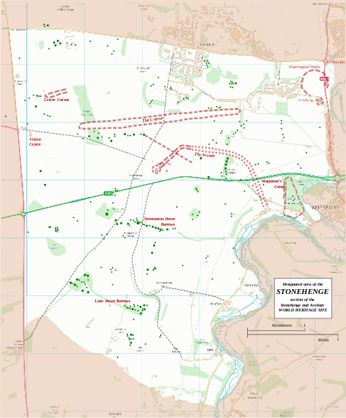
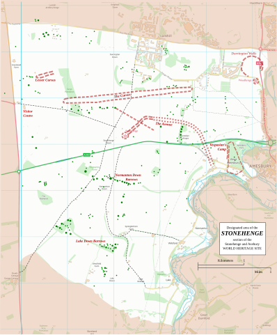
English: Boundary and key sites on the Avebury section of the Stonehenge, Avebury and Associated Sites World Heritage Site |
| Date | |
| Source | OS Open Data with additional material cited at World Heritage Site list No 373 |
| Author | RobinLeicester building on OS OpenData VextorMap District Raster files |
| Camera location | | View this and other nearby images on: OpenStreetMap |
|---|
Principal monuments and earthworks are shown in Red. Barrows are indicated by green dots.
Licensing
[edit]
This file is licensed by the Ordnance Survey of the United Kingdom under their OS OpenData License
In short: you are free to distribute and modify the file as long as you attribute (including year), the Ordnance Survey. Attribution: Contains Ordnance Survey data © Crown copyright and database right (year) Note: Derivative works can be licensed under any Creative Commons Attribution 3.0 Licence. |
_(St_Edwards_Crown).svg)
|
This file is licensed under the United Kingdom Open Government Licence v3.0. |
See also: Meta for information on usage on Wikimedia wikis.
|
File history
Click on a date/time to view the file as it appeared at that time.
| Date/Time | Thumbnail | Dimensions | User | Comment | |
|---|---|---|---|---|---|
| current | 22:36, 13 January 2015 | | 1,438 × 1,736 (1.57 MB) | RobinLeicester (talk | contribs) | User created page with UploadWizard |
You cannot overwrite this file.
File usage on Commons
There are no pages that use this file.
File usage on other wikis
The following other wikis use this file:
- Usage on cs.wikipedia.org
- Usage on de.wikipedia.org
- Usage on en.wikipedia.org
- Usage on fi.wikipedia.org
- Usage on fr.wikipedia.org
- Usage on fr.wikivoyage.org
- Usage on ja.wikipedia.org
- Usage on kw.wikipedia.org
- Usage on nl.wikipedia.org
- Usage on ru.wikipedia.org
- Usage on simple.wikipedia.org
- Usage on sl.wikipedia.org
- Usage on ur.wikipedia.org
- Usage on zh.wikipedia.org