File:Stolpersteine for the Pollack family, Amsterdam October 3, 2018.jpg
From Wikimedia Commons, the free media repository
Jump to navigation
Jump to search
![File:Stolpersteine for the Pollack family, Amsterdam October 3, 2018.jpg](https://upload.wikimedia.org/wikipedia/commons/thumb/7/75/Stolpersteine_for_the_Pollack_family%2C_Amsterdam_October_3%2C_2018.jpg/450px-Stolpersteine_for_the_Pollack_family%2C_Amsterdam_October_3%2C_2018.jpg?20181024203805)
Size of this preview: 450 × 600 pixels. Other resolutions: 180 × 240 pixels | 360 × 480 pixels | 576 × 768 pixels | 768 × 1,024 pixels | 1,536 × 2,048 pixels | 3,024 × 4,032 pixels.
Original file (3,024 × 4,032 pixels, file size: 3.05 MB, MIME type: image/jpeg)
File information
Structured data
Captions
Captions
Add a one-line explanation of what this file represents
Summary
[edit]DescriptionStolpersteine for the Pollack family, Amsterdam October 3, 2018.jpg |
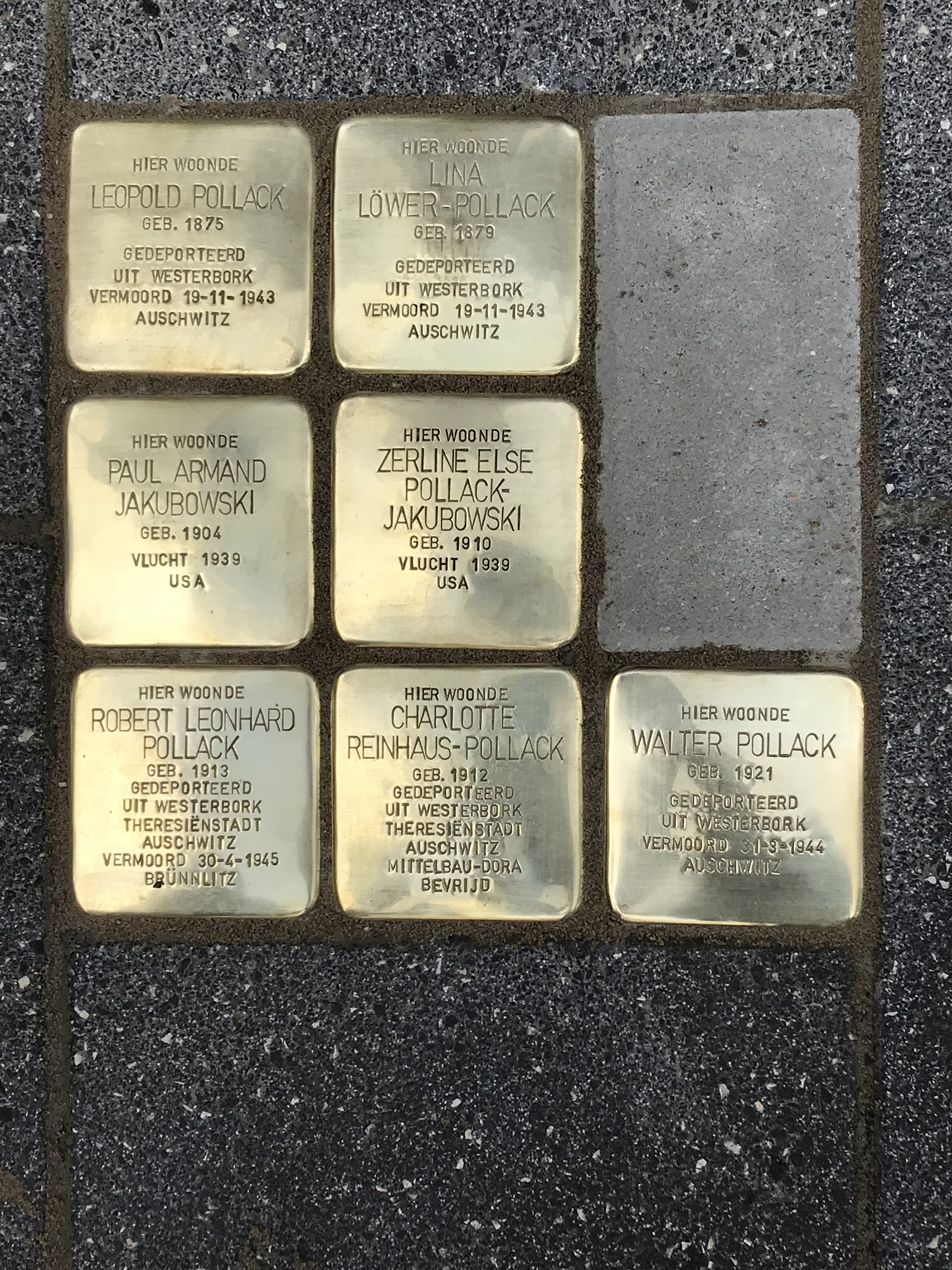
English: Gunter Demnig, a German environmental artist installs since 1996 in almost every country in Europe small, 10x10cm. stones with a brass plate in which he die-cuts information about the fate of a Holocaust victim. One stone, one person. Each stone is installed in front of the last address of the victim he/she chose freely. Until October 2018 70.000 such stones were almost entirely installed by Mr. Demnig himself.
Stolpersteine installation Beethovenstraat 55 |
Date | |
Source | Own work |
Author | Photojack50 |
Camera location | 52° 20′ 52.27″ N, 4° 52′ 37.97″ E ![]() ![]() | View this and other nearby images on: OpenStreetMap | ![]() |
---|
Licensing
[edit]I, the copyright holder of this work, hereby publish it under the following license:
![w:en:Creative Commons](https://upload.wikimedia.org/wikipedia/commons/thumb/7/79/CC_some_rights_reserved.svg/90px-CC_some_rights_reserved.svg.png)
![attribution](https://upload.wikimedia.org/wikipedia/commons/thumb/1/11/Cc-by_new_white.svg/24px-Cc-by_new_white.svg.png)
![share alike](https://upload.wikimedia.org/wikipedia/commons/thumb/d/df/Cc-sa_white.svg/24px-Cc-sa_white.svg.png)
This file is licensed under the Creative Commons Attribution-Share Alike 4.0 International license.
- You are free:
- to share – to copy, distribute and transmit the work
- to remix – to adapt the work
- Under the following conditions:
- attribution – You must give appropriate credit, provide a link to the license, and indicate if changes were made. You may do so in any reasonable manner, but not in any way that suggests the licensor endorses you or your use.
- share alike – If you remix, transform, or build upon the material, you must distribute your contributions under the same or compatible license as the original.
File history
Click on a date/time to view the file as it appeared at that time.
Date/Time | Thumbnail | Dimensions | User | Comment | |
---|---|---|---|---|---|
current | 20:38, 24 October 2018 | ![]() | 3,024 × 4,032 (3.05 MB) | Photojack50 (talk | contribs) | User created page with UploadWizard |
You cannot overwrite this file.
File usage on Commons
There are no pages that use this file.
File usage on other wikis
The following other wikis use this file:
- Usage on en.wikipedia.org
- Usage on hy.wikipedia.org
- Usage on nl.wikipedia.org
Metadata
This file contains additional information such as Exif metadata which may have been added by the digital camera, scanner, or software program used to create or digitize it. If the file has been modified from its original state, some details such as the timestamp may not fully reflect those of the original file. The timestamp is only as accurate as the clock in the camera, and it may be completely wrong.
Image title |
|
---|---|
Camera manufacturer | Apple |
Camera model | iPhone 7 Plus |
Exposure time | 1/665 sec (0.0015037593984962) |
F-number | f/1.8 |
ISO speed rating | 20 |
Date and time of data generation | 12:02, 3 October 2018 |
Lens focal length | 3.99 mm |
Latitude | 52° 20′ 52.27″ N |
Longitude | 4° 52′ 37.97″ E |
Altitude | 6 meters above sea level |
City shown | Amsterdam |
Orientation | Rotated 90° CCW |
Horizontal resolution | 72 dpi |
Vertical resolution | 72 dpi |
Software used | Elements Organizer 13.0 |
File change date and time | 17:14, 13 October 2018 |
Y and C positioning | Centered |
Exposure Program | Normal program |
Exif version | 2.21 |
Date and time of digitizing | 12:02, 3 October 2018 |
Meaning of each component |
|
APEX shutter speed | 9.3769797235953 |
APEX aperture | 1.6959938128384 |
APEX brightness | 8.4884560674034 |
APEX exposure bias | 0 |
Metering mode | Pattern |
Flash | Flash did not fire, compulsory flash suppression |
DateTimeOriginal subseconds | 048 |
DateTimeDigitized subseconds | 048 |
Supported Flashpix version | 1 |
Color space | Uncalibrated |
Sensing method | One-chip color area sensor |
Scene type | A directly photographed image |
Exposure mode | Auto exposure |
White balance | Auto white balance |
Digital zoom ratio | 2 |
Focal length in 35 mm film | 57 mm |
Scene capture type | Standard |
GPS time (atomic clock) | 10:02 |
Speed unit | Kilometers per hour |
Speed of GPS receiver | 0 |
Reference for direction of image | True direction |
Direction of image | 5.4369049053875 |
Geodetic survey data used | WGS-84 |
Reference for bearing of destination | True direction |
Bearing of destination | 5.4369049053875 |
GPS date | 3 October 2018 |
GPS tag version | 2.2.0.0 |
Supported Flashpix version | 0 |
Image width | 4,032 px |
Image height | 3,024 px |
Subject area |
|
Date metadata was last modified | 20:14, 13 October 2018 |
Code for country shown | NLD |
Sublocation of city shown | Oud Zuid |
Country shown | Netherlands |
Province or state shown | Noord-Holland |
IIM version | 4 |