File:Stolperstein Mungard Jens Keitum.jpg
Jump to navigation
Jump to search

Size of this preview: 550 × 599 pixels. Other resolutions: 220 × 240 pixels | 440 × 480 pixels | 705 × 768 pixels | 940 × 1,024 pixels | 1,358 × 1,480 pixels.
Original file (1,358 × 1,480 pixels, file size: 1.28 MB, MIME type: image/jpeg)
Captions
Captions
Add a one-line explanation of what this file represents
Summary
[edit]
| Description |
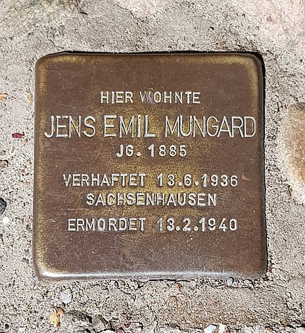
Deutsch: Stolperstein für Jens Mungard in Keitum |
| Date | |
| Source | Own work |
| Author | Jt wob |
| Camera location | | View this and other nearby images on: OpenStreetMap |
|---|
Licensing
[edit]

|
The copyright holder of this work allows anyone to use it for any purpose including unrestricted redistribution, commercial use, and modification.
Usage notes:
|
Original upload log
[edit]
Transferred from de.wikipedia to Commons by Wdwdbot using script bot_filetrans.pl (r109M).
The original description page was here. All following user names refer to de.wikipedia.
- 2018-07-15 17:14:24 Jt wob (1339168 Bytes) {{Information |Beschreibung = Stolperstein für Jens Mungard in Keitum |Quelle = own work |Urheber = |Datum = 10.07.2018 |Genehmigung = |Andere Versionen = |Anmerkungen = }}
File history
Click on a date/time to view the file as it appeared at that time.
| Date/Time | Thumbnail | Dimensions | User | Comment | |
|---|---|---|---|---|---|
| current | 20:58, 10 August 2018 | | 1,358 × 1,480 (1.28 MB) | Wdwdbot (talk | contribs) | Bot Move: Original uploader of this revision (#1) was Jt wob at de.wikipedia |
You cannot overwrite this file.
File usage on Commons
There are no pages that use this file.
File usage on other wikis
The following other wikis use this file:
- Usage on de.wikipedia.org
- Usage on frr.wikipedia.org
- Usage on gl.wikipedia.org
- Usage on www.wikidata.org