File:Stockton (S&DR) Bridge Road railway station (site), County Durham (geograph 4300027).jpg
Jump to navigation
Jump to search

Size of this preview: 800 × 600 pixels. Other resolutions: 320 × 240 pixels | 640 × 480 pixels | 1,024 × 768 pixels | 1,280 × 960 pixels | 1,600 × 1,200 pixels.
Original file (1,600 × 1,200 pixels, file size: 409 KB, MIME type: image/jpeg)
Captions
Captions
Add a one-line explanation of what this file represents
Summary
[edit]_Bridge_Road_railway_station_(site),_County_Durham_(geograph_4300027).jpg&action=edit§ion=1)
| Description |
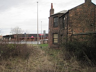
English: Stockton (S&DR) Bridge Road railway station (site), County Durham Converted in 1826 into a weigh house for the Stockton and Darlington Railway, this building may have also sold passenger tickets. Steam-hauled passenger trains ran between here and Darlington from 1833 to 1848. It continued as a goods station long after S&DR passengers had transferred to South Stockton railway station (see NZ4518 : South Stockton railway station (site), Yorkshire), which was only a few minutes walk away across the river Tees, and therefore located in Yorkshire. This site is also historic in that the first tracks of the Stockton and Darlington Railway were laid here in 1822. View north east over a former level crossing. As built we would be looking towards the coal staithes on the River Tees. |
| Date | |
| Source | From geograph.org.uk |
| Author | Nigel Thompson |
| Permission (Reusing this file) |
Creative Commons Attribution Share-alike license 2.0 |
| Attribution (required by the license) | Nigel Thompson / Stockton (S&DR) Bridge Road railway station (site), County Durham / |
,_Yorkshire_(geograph_6511232).jpg)
| Camera location | | View this and other nearby images on: OpenStreetMap |
|---|
_Bridge_Road_railway_station_(site),_County_Durham_(geograph_4300027).jpg¶ms=054.558064_N_-001.310788_E_globe:Earth_type:camera_source:geograph-osgb36(NZ44671831)_heading:22.00&language=en)
| Object location | | View this and other nearby images on: OpenStreetMap |
|---|
_Bridge_Road_railway_station_(site),_County_Durham_(geograph_4300027).jpg¶ms=054.558690_N_-001.310470_E_globe:Earth_class:object_type:object_source:geograph-osgb36(NZ44691838)_heading:22.00&language=en)
Licensing
[edit]_Bridge_Road_railway_station_(site),_County_Durham_(geograph_4300027).jpg&action=edit§ion=2)

|
This image was taken from the Geograph project collection. See this photograph's page on the Geograph website for the photographer's contact details. The copyright on this image is owned by Nigel Thompson and is licensed for reuse under the Creative Commons Attribution-ShareAlike 2.0 license.
|
This file is licensed under the Creative Commons Attribution-Share Alike 2.0 Generic license.
Attribution: Nigel Thompson
- You are free:
- to share – to copy, distribute and transmit the work
- to remix – to adapt the work
- Under the following conditions:
- attribution – You must give appropriate credit, provide a link to the license, and indicate if changes were made. You may do so in any reasonable manner, but not in any way that suggests the licensor endorses you or your use.
- share alike – If you remix, transform, or build upon the material, you must distribute your contributions under the same or compatible license as the original.
File history
Click on a date/time to view the file as it appeared at that time.
| Date/Time | Thumbnail | Dimensions | User | Comment | |
|---|---|---|---|---|---|
| current | 07:53, 23 June 2020 | | 1,600 × 1,200 (409 KB) | Lamberhurst (talk | contribs) | Transferred from geograph.co.uk using [https://tools.wmflabs.org/geograph2commons/ geograph2commons] |
You cannot overwrite this file.
File usage on Commons
The following page uses this file:
File usage on other wikis
The following other wikis use this file:
- Usage on en.wikipedia.org
_Bridge_Road_railway_station_(site),_County_Durham_(geograph_4300027).jpg&oldid=881300249)