File:Stockholm metrosystem map.svg
Jump to navigation
Jump to search

Size of this PNG preview of this SVG file: 689 × 599 pixels. Other resolutions: 276 × 240 pixels | 552 × 480 pixels | 883 × 768 pixels | 1,177 × 1,024 pixels | 2,355 × 2,048 pixels | 2,726 × 2,371 pixels.
Original file (SVG file, nominally 2,726 × 2,371 pixels, file size: 253 KB)
Captions
Captions
Add a one-line explanation of what this file represents
Summary
[edit]
| Description |
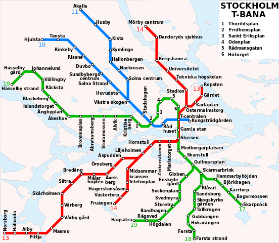
English: Map of the Stockholm metro Italiano: Mappa della metropolitana di Stoccolma. Deutsch: U-Bahn Karte von Stockholm |
| Date | |
| Source | Stockholm_metro_map.png |
| Author | user:xyboi, redraw by Stonyyy |
| Other versions | Derivative works of this file: Sweden Stockholm Municipality location map.svg |
Licensing
[edit]
This file is licensed under the Creative Commons Attribution-Share Alike 3.0 Unported license.
- You are free:
- to share – to copy, distribute and transmit the work
- to remix – to adapt the work
- Under the following conditions:
- attribution – You must give appropriate credit, provide a link to the license, and indicate if changes were made. You may do so in any reasonable manner, but not in any way that suggests the licensor endorses you or your use.
- share alike – If you remix, transform, or build upon the material, you must distribute your contributions under the same or compatible license as the original.
File history
Click on a date/time to view the file as it appeared at that time.
| Date/Time | Thumbnail | Dimensions | User | Comment | |
|---|---|---|---|---|---|
| current | 19:36, 19 August 2014 | | 2,726 × 2,371 (253 KB) | Stonyyy (talk | contribs) | Changed the name of Vreten to Solna Strand |
| 00:02, 26 August 2011 |  | 2,726 × 2,371 (253 KB) | Stonyyy (talk | contribs) |
You cannot overwrite this file.
File usage on Commons
The following 5 pages use this file:
File usage on other wikis
The following other wikis use this file:
- Usage on ar.wikipedia.org
- Usage on be-tarask.wikipedia.org
- Usage on ca.wikipedia.org
- Usage on cs.wikipedia.org
- Usage on de.wikipedia.org
- Usage on de.wikivoyage.org
- Usage on en.wikipedia.org
- Usage on en.wikivoyage.org
- Usage on es.wikipedia.org
- Usage on fr.wikipedia.org
- Métro de Stockholm
- Ligne T10 du métro de Stockholm
- Ligne T11 du métro de Stockholm
- Ligne T13 du métro de Stockholm
- Ligne T14 du métro de Stockholm
- Ligne T17 du métro de Stockholm
- Ligne T18 du métro de Stockholm
- Ligne T19 du métro de Stockholm
- Hjulsta (métro de Stockholm)
- Tensta (métro de Stockholm)
- Rinkeby (métro de Stockholm)
- Rissne (métro de Stockholm)
- Hornstull (métro de Stockholm)
- Odenplan (métro de Stockholm)
- Hässelby Strand (métro de Stockholm)
- Åkeshov (métro de Stockholm)
- Usage on gl.wikipedia.org
- Usage on he.wikipedia.org
- Usage on he.wikivoyage.org
- Usage on hu.wikipedia.org
- Usage on hy.wikipedia.org
- Usage on id.wikipedia.org
- Usage on it.wikipedia.org
- Usage on lb.wikipedia.org
- Usage on mk.wikipedia.org
- Usage on sr.wikipedia.org
- Usage on sv.wikipedia.org
- Usage on th.wikipedia.org
- Usage on tt.wikipedia.org
- Usage on uk.wikipedia.org
- Usage on uz.wikipedia.org
- Usage on www.wikidata.org