File:Stink pipe, New Barnet, Shaftesbury Avenue 1.jpg
Jump to navigation
Jump to search

Size of this preview: 276 × 599 pixels. Other resolution: 281 × 610 pixels.
Original file (281 × 610 pixels, file size: 136 KB, MIME type: image/jpeg)
Captions
Captions
Add a one-line explanation of what this file represents
Summary
[edit]
| Description |
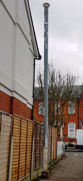
English: Stink pipe in Shaftesbury Avenue, New Barnet, inscribed 'Adams Hydraulics Ltd, York'. Stink pipes (formally called sewer ventilation pipes) were installed in the late nineteenth and early twentieth centuries to carry flammable and noxious gases from sewers to a safe height above the street. |
| Date | |
| Source | Own work |
| Author | Dudley Miles |
| Camera location | | View this and other nearby images on: OpenStreetMap |
|---|
Licensing
[edit]
I, the copyright holder of this work, hereby publish it under the following license:
This file is licensed under the Creative Commons Attribution-Share Alike 4.0 International license.
- You are free:
- to share – to copy, distribute and transmit the work
- to remix – to adapt the work
- Under the following conditions:
- attribution – You must give appropriate credit, provide a link to the license, and indicate if changes were made. You may do so in any reasonable manner, but not in any way that suggests the licensor endorses you or your use.
- share alike – If you remix, transform, or build upon the material, you must distribute your contributions under the same or compatible license as the original.
File history
Click on a date/time to view the file as it appeared at that time.
| Date/Time | Thumbnail | Dimensions | User | Comment | |
|---|---|---|---|---|---|
| current | 22:01, 12 November 2020 | | 281 × 610 (136 KB) | Dudley Miles (talk | contribs) | Uploaded own work with UploadWizard |
You cannot overwrite this file.
File usage on Commons
The following page uses this file: