File:Steps leading to the top of the Idanre Hill.jpg
Jump to navigation
Jump to search

Size of this preview: 450 × 600 pixels. Other resolutions: 180 × 240 pixels | 360 × 480 pixels | 576 × 768 pixels | 768 × 1,024 pixels | 1,536 × 2,048 pixels | 3,024 × 4,032 pixels.
Original file (3,024 × 4,032 pixels, file size: 6.4 MB, MIME type: image/jpeg)
Captions
Captions
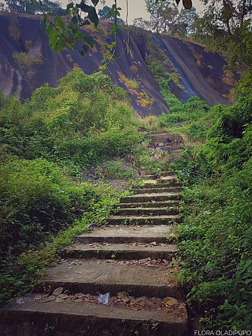
To reach the top of the Hill stairs need to be taken
Summary
[edit]
| Description |
English: There are 660 steps in total to reach the top of the Hill and the Ancient Town of Idanre. There are stop overs on the way to rest while going. It's perfect for hikers.
Flora Oladipupo (talk) 15:19, 27 March 2020 (UTC)FloraFlora Oladipupo (talk) 15:19, 27 March 2020 (UTC)
Igbo: Enwere nzọụkwụ isii na iri isii iji ruo elu ugwu na obodo Idanre oge ochie. Enwere nkwụsị nkwụsị n'ụzọ iji zuru ike mgbe ị na-aga. O zuru oke maka ndị njem.
Flora Oladipupo (talk) 15:19, 27 Maachị 2020 (UTC)FloraFlora Oladipupo (talk) 15 :19, 27 Maachị 2020 (UTC)
|
||
| Date | |||
| Source | Own work | ||
| Author | Flora Oladipupo |
| Camera location | | View this and other nearby images on: OpenStreetMap |
|---|
Licensing
[edit]
I, the copyright holder of this work, hereby publish it under the following license:
This file is licensed under the Creative Commons Attribution-Share Alike 4.0 International license.
- You are free:
- to share – to copy, distribute and transmit the work
- to remix – to adapt the work
- Under the following conditions:
- attribution – You must give appropriate credit, provide a link to the license, and indicate if changes were made. You may do so in any reasonable manner, but not in any way that suggests the licensor endorses you or your use.
- share alike – If you remix, transform, or build upon the material, you must distribute your contributions under the same or compatible license as the original.

|
This image was uploaded as part of Wiki Loves Africa 2020 photographic contest.
|
File history
Click on a date/time to view the file as it appeared at that time.
| Date/Time | Thumbnail | Dimensions | User | Comment | |
|---|---|---|---|---|---|
| current | 15:19, 27 March 2020 | | 3,024 × 4,032 (6.4 MB) | Flora Oladipupo (talk | contribs) | Uploaded own work with UploadWizard |
You cannot overwrite this file.
File usage on Commons
The following page uses this file: