File:Steiermark Vischer 1678.jpg
Jump to navigation
Jump to search

Size of this preview: 682 × 599 pixels. Other resolutions: 273 × 240 pixels | 546 × 480 pixels | 874 × 768 pixels | 1,165 × 1,024 pixels | 2,331 × 2,048 pixels | 8,916 × 7,835 pixels.
Original file (8,916 × 7,835 pixels, file size: 55.17 MB, MIME type: image/jpeg)
Captions
Captions
Add a one-line explanation of what this file represents
Summary
[edit]| Warning | The original file is very high-resolution. It might not load properly or could cause your browser to freeze when opened at full size. |
|---|
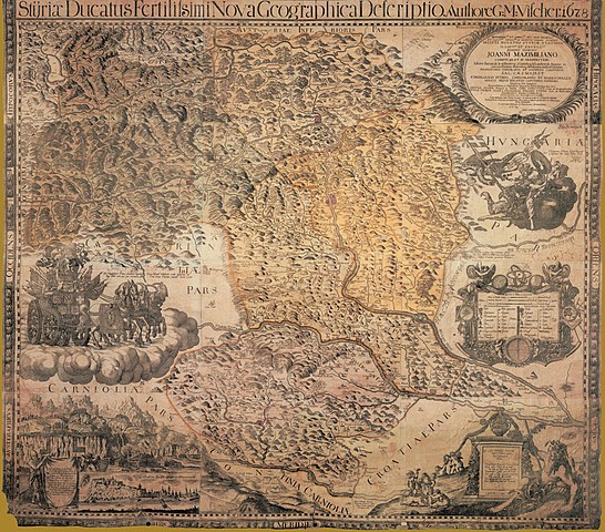
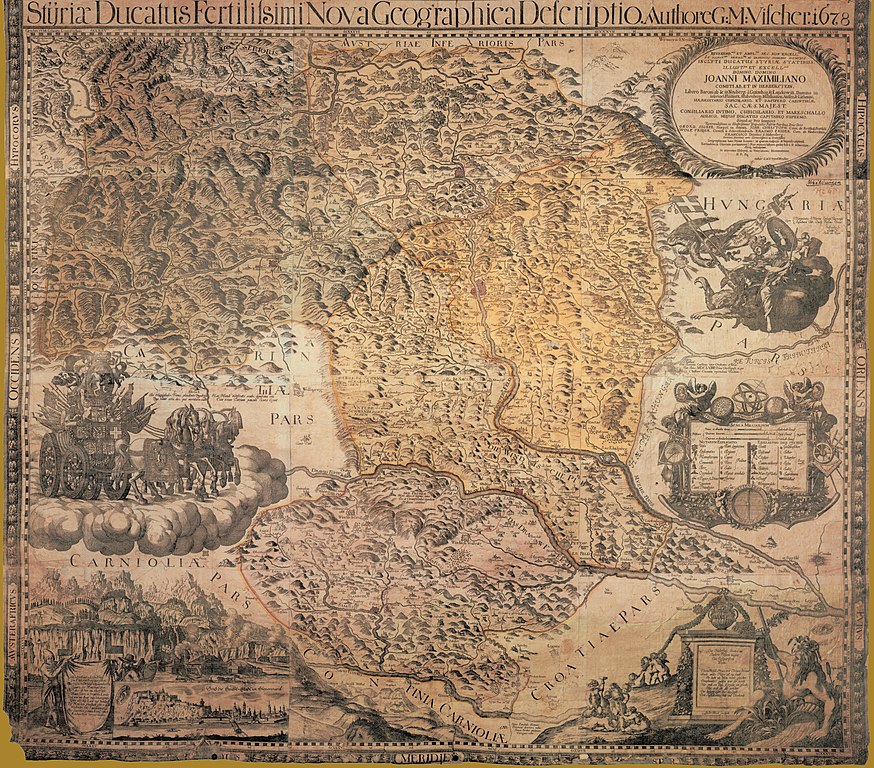
| Description | historische Landkarte: Styriae Ducatus Fertilitsimi Nova Geographica Descriptio (wegen ihres Titels auch „Fertilissima“ genannt). Authore G:M.Vischer.1678, | ||||||||||||||||||||
| Date | |||||||||||||||||||||
| Source | steiermärkisches Landesarchiv | ||||||||||||||||||||
| Author |
|
||||||||||||||||||||
| Permission (Reusing this file) |
historische Landkarte aus 17. Jahrhundert, freies Werk | ||||||||||||||||||||
| Other versions |
 |
||||||||||||||||||||

Licensing
[edit]
|
This work is in the public domain in its country of origin and other countries and areas where the copyright term is the author's life plus 100 years or fewer. | |
| This file has been identified as being free of known restrictions under copyright law, including all related and neighboring rights. | |
File history
Click on a date/time to view the file as it appeared at that time.
| Date/Time | Thumbnail | Dimensions | User | Comment | |
|---|---|---|---|---|---|
| current | 18:08, 1 July 2010 | | 8,916 × 7,835 (55.17 MB) | Josef Moser (talk | contribs) | {{Information |Description=historische Landkarte: Styriae Ducatus Fertilitsimi Nova Geographica Descriptio. Authore G:M.Vischer.1678 |Source=steiermärkisches Landesarchiv |Date=1678 |Author=G:M.Vischer. |Permission=historische Landkarte aus 17. Jahrhunde |
You cannot overwrite this file.
File usage on Commons
The following 2 pages use this file:
File usage on other wikis
The following other wikis use this file:
- Usage on de.wikipedia.org
Metadata
Categories:
- Maps of the Duchy of Styria
- Innerösterreich
- History of Graz
- Maps of Bezirk Deutschlandsberg
- Bezirk Leibnitz
- Bezirk Voitsberg
- Bezirk Weiz
- Bezirk Graz-Umgebung
- Bezirk Hartberg-Fürstenfeld
- Bezirk Bruck-Mürzzuschlag
- Bezirk Leoben
- Old maps of Styria
- Bezirk Liezen
- Bezirk Murau
- Bezirk Südoststeiermark
- Bezirk Murtal
- Works by Georg Matthäus Vischer
- 17th-century maps of Slovenia
- Steiermärkisches Landesarchiv, Graz - Maps