File:Stazione di Rieti dall'alto.jpg
From Wikimedia Commons, the free media repository
Jump to navigation
Jump to search
![File:Stazione di Rieti dall'alto.jpg](https://upload.wikimedia.org/wikipedia/commons/thumb/b/b4/Stazione_di_Rieti_dall%27alto.jpg/800px-Stazione_di_Rieti_dall%27alto.jpg?20181107022707)
Size of this preview: 800 × 268 pixels. Other resolutions: 320 × 107 pixels | 640 × 214 pixels | 1,484 × 497 pixels.
Original file (1,484 × 497 pixels, file size: 523 KB, MIME type: image/jpeg)
File information
Structured data
Captions
Captions
Add a one-line explanation of what this file represents
Summary
[edit]DescriptionStazione di Rieti dall'alto.jpg |
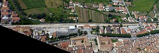
Italiano: La stazione ferroviaria di Rieti (Lazio) vista dall'alto, sulla linea a binario unico e non elettrificato Terni-L'Aquila-Sulmona.
English: The railway station of Rieti (central Italy), on the diesel and single track Terni-L'Aquila-Sulmona railway, as seen from above |
|||
Date | ||||
Source |
|
|||
Author | Claudio Vosti |
Camera location | 42° 23′ 40.23″ N, 12° 51′ 27.86″ E ![]() ![]() | View this and other nearby images on: OpenStreetMap | ![]() |
---|
Licensing
[edit]![w:en:Creative Commons](https://upload.wikimedia.org/wikipedia/commons/thumb/7/79/CC_some_rights_reserved.svg/90px-CC_some_rights_reserved.svg.png)
![attribution](https://upload.wikimedia.org/wikipedia/commons/thumb/1/11/Cc-by_new_white.svg/24px-Cc-by_new_white.svg.png)
![share alike](https://upload.wikimedia.org/wikipedia/commons/thumb/d/df/Cc-sa_white.svg/24px-Cc-sa_white.svg.png)
This file is licensed under the Creative Commons Attribution-Share Alike 2.0 Generic license.
- You are free:
- to share – to copy, distribute and transmit the work
- to remix – to adapt the work
- Under the following conditions:
- attribution – You must give appropriate credit, provide a link to the license, and indicate if changes were made. You may do so in any reasonable manner, but not in any way that suggests the licensor endorses you or your use.
- share alike – If you remix, transform, or build upon the material, you must distribute your contributions under the same or compatible license as the original.
Annotations InfoField | This image is annotated: View the annotations at Commons |
89
7
100
102
1484
497
Italiano: Raccordo ferroviario dismesso che conduceva allo zuccherificio e alla Snia Viscosa
English: Disused railway link which led to the sugar factory and to the Snia Viscosa textile plant
2
230
141
37
1484
497
Italiano: Binari in direzione Terni / Passaggio a livello di viale Maraini
English: Tracks heading to Terni and to the Maraini Avenue level crossing
720
228
184
48
1484
497
Italiano: Fabbricato viaggiatori
English: Passenger building
646
243
61
37
1484
497
Italiano: Magazzino merci
English: Goods shed
1426
208
56
24
1484
497
Italiano: Binari in direzione L'Aquila
English: L'Aquila-heading tracks
1297
202
30
32
1484
497
Italiano: Passaggio a livello di via Angelo Maria Ricci
English: Angelo Maria Ricci street level crossing
293
252
349
57
1484
497
Italiano: Ex scalo merci
English: Former freight area
646
286
111
56
1484
497
Italiano: Autostazione autobus Cotral
English: Cotral buses station
846
354
58
87
1484
497
Italiano: Piazza Mazzini
English: Mazzini Square
File history
Click on a date/time to view the file as it appeared at that time.
Date/Time | Thumbnail | Dimensions | User | Comment | |
---|---|---|---|---|---|
current | 02:27, 7 November 2018 | ![]() | 1,484 × 497 (523 KB) | Una giornata uggiosa '94 (talk | contribs) | User created page with UploadWizard |
You cannot overwrite this file.
File usage on Commons
The following page uses this file:
Metadata
This file contains additional information such as Exif metadata which may have been added by the digital camera, scanner, or software program used to create or digitize it. If the file has been modified from its original state, some details such as the timestamp may not fully reflect those of the original file. The timestamp is only as accurate as the clock in the camera, and it may be completely wrong.
Camera manufacturer | Panasonic |
---|---|
Camera model | DMC-FT4 |
Exposure time | 1/1,000 sec (0.001) |
F-number | f/3.3 |
ISO speed rating | 100 |
Date and time of data generation | 14:04, 27 May 2018 |
Lens focal length | 4.9 mm |
Latitude | 42° 23′ 40.23″ N |
Longitude | 12° 51′ 27.86″ E |
Altitude | 1,392 meters above sea level |
Width | 4,000 px |
Height | 3,000 px |
Bits per component |
|
Pixel composition | RGB |
Orientation | Normal |
Number of components | 3 |
Horizontal resolution | 180 dpi |
Vertical resolution | 180 dpi |
Software used | Adobe Photoshop CS6 (Windows) |
File change date and time | 01:55, 7 November 2018 |
Y and C positioning | Co-sited |
Exposure Program | Normal program |
Exif version | 2.3 |
Date and time of digitizing | 14:04, 27 May 2018 |
Meaning of each component |
|
Image compression mode | 4 |
APEX shutter speed | 9.965784 |
APEX aperture | 3.444932 |
APEX exposure bias | 0 |
Maximum land aperture | 3.4453125 APEX (f/3.3) |
Metering mode | Pattern |
Light source | Unknown |
Flash | Flash did not fire, compulsory flash suppression |
Supported Flashpix version | 1 |
Color space | sRGB |
Sensing method | One-chip color area sensor |
File source | Digital still camera |
Scene type | A directly photographed image |
Custom image processing | Normal process |
Exposure mode | Auto exposure |
White balance | Auto white balance |
Digital zoom ratio | 0 |
Focal length in 35 mm film | 28 mm |
Scene capture type | Standard |
Scene control | None |
Contrast | Normal |
Saturation | Normal |
Sharpness | Normal |
GPS time (atomic clock) | 13:03 |
Receiver status | Measurement in progress |
Measurement mode | 2-dimensional measurement |
Measurement precision | Fair (1.2) |
Reference for direction of image | True direction |
Direction of image | 0 |
Geodetic survey data used | WGS-84 |
Name of GPS area | Rieti |
GPS date | 27 May 2018 |
GPS tag version | 0.0.3.2 |
Date metadata was last modified | 02:55, 7 November 2018 |
Unique ID of original document | BD54A9B5D995224B5F9A603CE5E1AA97 |
IIM version | 39,614 |