File:States of Mexico.png
Jump to navigation
Jump to search
No higher resolution available.
States_of_Mexico.png (600 × 420 pixels, file size: 77 KB, MIME type: image/png)
Captions
Captions
Add a one-line explanation of what this file represents
Summary
[edit]

|
File:Regions of Mexico.svg is a vector version of this file. It should be used in place of this PNG file when not inferior.
File:States of Mexico.png → File:Regions of Mexico.svg
For more information, see Help:SVG. |
 |
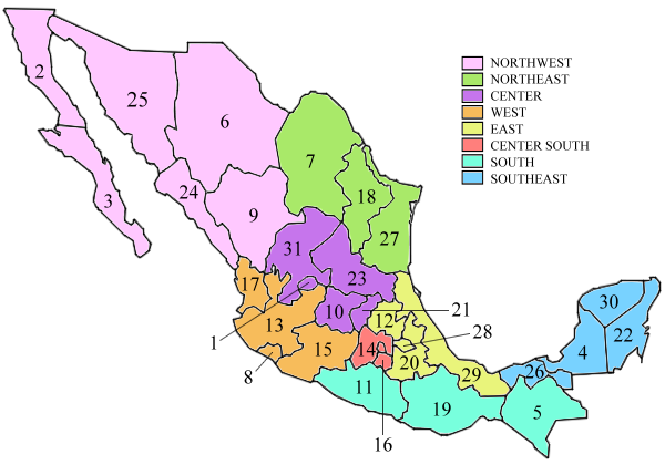
| Description | Map of the states of Mexico |
| Date | 31 August 2006 (original upload date) |
| Source | Transferred from en.wikipedia to Commons. |
| Author | Lancini87 at English Wikipedia |
Legende
[edit]
german, taken from https://de.wikivoyage.org/wiki/Mexiko
Bundesländer sind (hinzu kommt die Hauptstadt Mexico, DF als Bundesdistrikt):
| Nordwesten |
| 2. Baja California |
| 3. Baja California Sur |
| 6. Chihuahua |
| 9. Durango |
| 24. Sinaloa |
| 25. Sonora |
| Nordosten |
| 7. Coahuila |
| 18. Nuevo León |
| 27. Tamaulipas |
| Zentrum |
| 1. Aguascalientes |
| 10. Guanajuato |
| 21. Querétaro |
| 23. San Luis Potosí |
| 31. Zacatecas |
| Westen |
| 8. Colima |
| 13. Jalisco |
| 15. Michoacán |
| 17. Nayarit |
| Osten |
| 12. Hidalgo |
| 20. Puebla |
| 28. Tlaxcala |
| 29. Veracruz |
| Zentraler Süden |
| 14. México (Bundesstaat) |
| 16. Morelos |
| Mexico, DF |
| Süden |
| 5. Chiapas |
| 11. Guerrero |
| 19. Oaxaca |
| Südosten |
| 4. Campeche |
| 22. Quintana Roo |
| 26. Tabasco |
| 30. Yucatán |
Licensing
[edit]
| This work has been released into the public domain by its author, Lancini87 at English Wikipedia. This applies worldwide. In some countries this may not be legally possible; if so: Lancini87 grants anyone the right to use this work for any purpose, without any conditions, unless such conditions are required by law. |
Original upload log
[edit]
The original description page was here. All following user names refer to en.wikipedia.
- 2006-08-31 16:29 Lancini87 600×420×8 (79195 bytes)
File history
Click on a date/time to view the file as it appeared at that time.
| Date/Time | Thumbnail | Dimensions | User | Comment | |
|---|---|---|---|---|---|
| current | 23:45, 30 July 2007 | | 600 × 420 (77 KB) | Holly Cheng (talk | contribs) | {{Convert to SVG}} {{Information |Description=Map of the states of Mexico |Source=Originally from [http://en.wikipedia.org en.wikipedia]; description page is/was [http://en.wikipedia.org/w/index.php?title=Image%3AStates_of_Mexico.png here]. |Date=2006-08- |
You cannot overwrite this file.
File usage on Commons
There are no pages that use this file.
File usage on other wikis
The following other wikis use this file:
- Usage on en.wikipedia.org
- Usage on he.wikipedia.org
- Usage on ig.wikipedia.org