File:Stary Sącz (gmina) location map.png

Original file (2,044 × 1,935 pixels, file size: 700 KB, MIME type: image/png)
Captions
Captions
Summary
[edit]_location_map.png&action=edit§ion=1)
| Description |
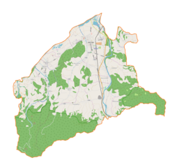
English: Location map |
| Date | |
| Source | Own work |
| Author | Smat |
| Description |
Polski: Mapa gminy Stary Sącz, Polska
English: Map of Stary Sącz (gmina), Poland |
|||||||||
| Date | ||||||||||
| Source | You may find a page on the OpenStreetMap wiki page for Stary Sącz (gmina) | |||||||||
| Creator |
OpenStreetMap contributors OpenStreetMap contributors |
|||||||||
| Permission (Reusing this file) |
OpenStreetMap data is available under the Open Database License (details). Map tiles are licensed under the Creative Commons Attribution-ShareAlike 2.0 license (CC-BY-SA 2.0).
This file is licensed under the Creative Commons Attribution-Share Alike 2.0 Generic license.
|
|||||||||
| Geotemporal data | ||||||||||
| Bounding box |
|
|||||||||
| Georeferencing | If inappropriate please set warp_status = skip to hide. | |||||||||
Licensing
[edit]_location_map.png&action=edit§ion=2)
| This work contains information from OpenStreetMap, which is made available under the Open Database License (ODbL).
The ODbL does not require any particular license for maps produced from ODbL data. Prior to 1 August 2020, map tiles produced by the OpenStreetMap Foundation were licensed under the CC-BY-SA-2.0 license. Maps produced by other people may be subject to other licences. |
File history
Click on a date/time to view the file as it appeared at that time.
| Date/Time | Thumbnail | Dimensions | User | Comment | |
|---|---|---|---|---|---|
| current | 11:12, 8 April 2018 | | 2,044 × 1,935 (700 KB) | Smat (talk | contribs) | User created page with UploadWizard |
You cannot overwrite this file.
File usage on Commons
There are no pages that use this file.
File usage on other wikis
The following other wikis use this file:
- Usage on pl.wikipedia.org
- Gołkowice Górne
- Stary Sącz
- Gaboń
- Barcice Dolne
- Gołkowice Dolne
- Łazy Biegonickie
- Moszczenica Niżna
- Moszczenica Wyżna
- Myślec
- Skrudzina
- Wola Krogulecka
- Mostki (województwo małopolskie)
- Popowice (województwo małopolskie)
- Przysietnica (województwo małopolskie)
- Synagoga w Starym Sączu
- Praczka (Gaboń)
- Sapieniec (Barcice)
- Podsapieniec
- Dominików
- Facimiech (Barcice)
- Barcice (województwo małopolskie)
- RTON Przehyba
- Zabronie
- Parafia św. Elżbiety Węgierskiej w Starym Sączu
- Parafia Miłosierdzia Bożego w Starym Sączu
- Stary Sącz (stacja kolejowa)
- Most im. św. Kingi
- Barcice (przystanek kolejowy)
- Grabowski Potok
- Cmentarz wojenny nr 348 – Stary Sącz
- Cmentarz wojenny nr 347 – Barcice
- Muzeum Regionalne w Starym Sączu
- Parafia św. Jana Chrzciciela w Przysietnicy
- Parafia św. Mikołaja w Moszczenicy Niżnej
- Parafia św. Antoniego Padewskiego w Gołkowicach Górnych
- Parafia Matki Bożej Częstochowskiej w Gaboniu
- Parafia Najświętszej Maryi Panny Wniebowziętej w Barcicach
- Ołtarz Papieski w Starym Sączu
- Głucha Dolina (Barcice)
- Grabowce (Barcice)
- Kliny (Barcice)
- Maliniki
- Paryje (Barcice)
- Pierzwia
- Potoki (Barcice)
- Skrajnia (Barcice)
- Strzębiałki (Barcice)
- Wdżary
- Bania (Moszczenica Wyżna)
- Dwór (Moszczenica Wyżna)
View more global usage of this file.
_location_map.png)
_location_map.png&oldid=706039894)