File:Stadttafel 148 Arbeiterwohnsiedlung Menzelstraße und Schnabelstraße vor dem Spielplatz am Martensplatz in Hannover-Oberricklingen.jpg

Original file (2,252 × 4,000 pixels, file size: 6.7 MB, MIME type: image/jpeg)
Captions
Captions
Summary
[edit]
| Description |
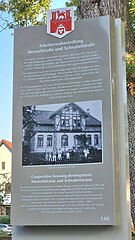
Deutsch: Die zweisprachige Stadttafel Nummer 148 auf der Grünfläche vor dem Spielplatz am Martensplatz in Hannover-Oberricklingen titelt in deutsch:
English:
|
| Date | |
| Source | Own work |
| Author | Bernd Schwabe |
| Camera location | | View this and other nearby images on: OpenStreetMap |
|---|
Licensing
[edit]
- You are free:
- to share – to copy, distribute and transmit the work
- to remix – to adapt the work
- Under the following conditions:
- attribution – You must give appropriate credit, provide a link to the license, and indicate if changes were made. You may do so in any reasonable manner, but not in any way that suggests the licensor endorses you or your use.
- share alike – If you remix, transform, or build upon the material, you must distribute your contributions under the same or compatible license as the original.
File history
Click on a date/time to view the file as it appeared at that time.
| Date/Time | Thumbnail | Dimensions | User | Comment | |
|---|---|---|---|---|---|
| current | 13:23, 4 July 2023 | | 2,252 × 4,000 (6.7 MB) | Bernd Schwabe in Hannover (talk | contribs) | Uploaded own work with UploadWizard |
You cannot overwrite this file.
File usage on Commons
The following page uses this file:
File usage on other wikis
The following other wikis use this file:
- Usage on de.wikipedia.org
- Usage on www.wikidata.org