File:Staatslijn F.png
Jump to navigation
Jump to search

Size of this preview: 800 × 593 pixels. Other resolutions: 320 × 237 pixels | 640 × 474 pixels | 1,024 × 759 pixels | 1,280 × 949 pixels | 1,531 × 1,135 pixels.
Original file (1,531 × 1,135 pixels, file size: 1.89 MB, MIME type: image/png)
Captions
Captions
Add a one-line explanation of what this file represents
Summary
[edit]
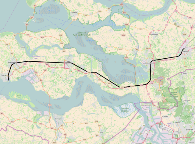
| Description | Staatslijn F, Roosendaal - Vlissingen |
| Source | openstreetmap.org. |
| Author | OpenStreetMap contributors |
| Permission (Reusing this file) |
All OpenStreetMap data and maps are Creative Commons "CC-BY-SA 2.0" licensed |
Licensing
[edit]
This file is licensed under the Creative Commons Attribution-Share Alike 2.0 Generic license.
- You are free:
- to share – to copy, distribute and transmit the work
- to remix – to adapt the work
- Under the following conditions:
- attribution – You must give appropriate credit, provide a link to the license, and indicate if changes were made. You may do so in any reasonable manner, but not in any way that suggests the licensor endorses you or your use.
- share alike – If you remix, transform, or build upon the material, you must distribute your contributions under the same or compatible license as the original.
File history
Click on a date/time to view the file as it appeared at that time.
| Date/Time | Thumbnail | Dimensions | User | Comment | |
|---|---|---|---|---|---|
| current | 14:30, 2 June 2016 | | 1,531 × 1,135 (1.89 MB) | Vunz (talk | contribs) | less cluttered |
| 08:06, 9 July 2014 |  | 1,437 × 953 (1.49 MB) | Vunz (talk | contribs) | improved | |
| 14:10, 2 May 2010 |  | 1,063 × 772 (997 KB) | Vunz (talk | contribs) | thicker line | |
| 13:17, 1 October 2009 |  | 1,063 × 772 (997 KB) | Vunz (talk | contribs) | Category:Rail transport maps of the Netherlands | |
| 19:02, 26 April 2007 |  | 828 × 358 (18 KB) | Martijnvdputten (talk | contribs) | {{Information |Description=kaart van het tracé van de Zeeuwse Lijn, Staatslijn F |Source=Gebaseerd op kaart van http://www.demis.nl/wms/mapclip.htm (vrije software gebaseerd op vrije database) |Date=25 februari 2007 |Author=nl:Gebruiker:Xyboi |other | |
| 07:10, 5 April 2007 |  | 644 × 471 (31 KB) | Martijnvdputten (talk | contribs) | {{Information |Description=kaart van het tracé van Staatslijn F |Source=Gebaseerd op kaart van http://www.demis.nl/wms/mapclip.htm (vrije software gebaseerd op vrije database) |Date=2007-04-05 |Author=bewerkt door Martijn van der Putten |Permission= }} [ |
You cannot overwrite this file.
File usage on Commons
The following 6 pages use this file:
- User:Chumwa/OgreBot/Potential transport maps/2016 June 1-10
- User:Chumwa/OgreBot/Public transport information/2016 June 1-10
- User:Chumwa/OgreBot/Transport Maps/2016 June 1-10
- User:Chumwa/OgreBot/Travel and communication maps/2016 June 1-10
- File:StaatslijnF.png (file redirect)
- Category:Roosendaal - Vlissingen railway
File usage on other wikis
The following other wikis use this file:
- Usage on de.wikipedia.org
- Usage on en.wikipedia.org
- Usage on fr.wikipedia.org
- Usage on fy.wikipedia.org
- Usage on nl.wikipedia.org
- Usage on no.wikipedia.org
- Usage on ru.wikipedia.org
- Usage on www.wikidata.org
- Usage on zea.wikipedia.org