File:St Mary's church in Sporle - geograph.org.uk - 1270651.jpg
Jump to navigation
Jump to search
No higher resolution available.
St_Mary's_church_in_Sporle_-_geograph.org.uk_-_1270651.jpg (640 × 536 pixels, file size: 88 KB, MIME type: image/jpeg)
Captions
Captions
Add a one-line explanation of what this file represents
Summary
[edit]
| Description |
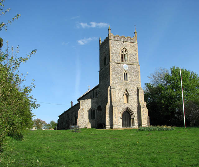
English: St Mary's church in Sporle St Mary's church is located at the northern end of the village, above the primary school > https://www.geograph.org.uk/photo/1270629 east of The Street > https://www.geograph.org.uk/photo/1270521 - the main thoroughfare through the village. The building dates mainly from the 13th and 14th centuries but was restored in Victorian times.. It still houses a C13 Purbeck marble font > https://www.geograph.org.uk/photo/1966216 with shallow blank arcading, a (restored) C15 nave roof and the remains of a 15th century parclose screen in the south aisle > https://www.geograph.org.uk/photo/1966204. The probably greatest treasure of the church is a medieval wall painting > https://www.geograph.org.uk/photo/1966208 depicting the legend of St Catherine in a number of coloured panels. She was born in Alexandria and raised a pagan, but converted to Christianity in her late teens. She was condemned to death on the breaking wheel, an instrument of torture but according to legend the wheel broke when she touched it and she was consequently beheaded. St Catherine became one of the most influential saints in the religious culture of the late middle ages. Her principal symbol is the spiked wheel, which has become known as the Catherine wheel. |
| Date | |
| Source | From geograph.org.uk |
| Author | Evelyn Simak |
| Attribution (required by the license) | Evelyn Simak / St Mary's church in Sporle / |
| Camera location | | View this and other nearby images on: OpenStreetMap |
|---|
_heading:112.00&language=en)
| Object location | | View this and other nearby images on: OpenStreetMap |
|---|
_heading:112.00&language=en)
Licensing
[edit]

|
This image was taken from the Geograph project collection. See this photograph's page on the Geograph website for the photographer's contact details. The copyright on this image is owned by Evelyn Simak and is licensed for reuse under the Creative Commons Attribution-ShareAlike 2.0 license.
|
This file is licensed under the Creative Commons Attribution-Share Alike 2.0 Generic license.
Attribution: Evelyn Simak
- You are free:
- to share – to copy, distribute and transmit the work
- to remix – to adapt the work
- Under the following conditions:
- attribution – You must give appropriate credit, provide a link to the license, and indicate if changes were made. You may do so in any reasonable manner, but not in any way that suggests the licensor endorses you or your use.
- share alike – If you remix, transform, or build upon the material, you must distribute your contributions under the same or compatible license as the original.
File history
Click on a date/time to view the file as it appeared at that time.
| Date/Time | Thumbnail | Dimensions | User | Comment | |
|---|---|---|---|---|---|
| current | 03:49, 27 February 2011 | | 640 × 536 (88 KB) | GeographBot (talk | contribs) | == {{int:filedesc}} == {{Information |description={{en|1=St Mary's church in Sporle St Mary's church is located at the northern end of the village, above the primary school > http://www.geograph.org.uk/photo/1270629 east of The Street > http://www.geograp |
You cannot overwrite this file.
File usage on Commons
The following page uses this file:
File usage on other wikis
The following other wikis use this file:
- Usage on en.wikipedia.org
- Usage on www.wikidata.org