File:St Conval and Argyle Stones - geograph.org.uk - 1705870.jpg
Jump to navigation
Jump to search
No higher resolution available.
St_Conval_and_Argyle_Stones_-_geograph.org.uk_-_1705870.jpg (640 × 429 pixels, file size: 231 KB, MIME type: image/jpeg)
Captions
Captions
Add a one-line explanation of what this file represents
Summary
[edit]
| Description |
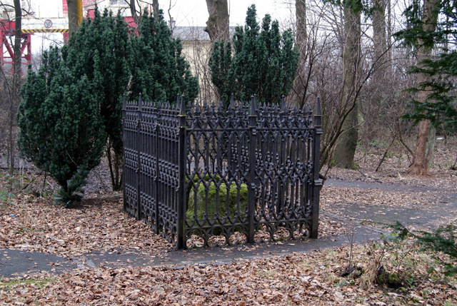
English: St Conval and Argyle Stones. Located between the Normandy Hotel and the "swing" bridge on the A8. See also 1705873
The following extract is from the Renfrewshire Council walking leaflet "Renfrew and its rivers". Legends of the St Conval and Argyll Stones According to tradition, one of these weighty stones floated out to sea from Ireland in the sixth century AD when St Conval was resting on it, having decided to found a new church. He and the stone floated up the Firth of Clyde and came to a stop at Renfrew. St Conval then went on to found his church just across the River Cart at Inchinnan. Such was the power of the legend that the stone became a shrine for pilgrims and sick people. Rainwater collected from the hollow on top of the stone was believed to have healing powers. More recently, but still over 300 years ago, somebody else took a rest at the stones - with even more fateful consequences. The 9th Earl of Argyll, part of the failed rebellion against the new King James VII and II in 1685, had fled and was making his way incognito to Renfrew from Inchinnan. Like St Conval a thousand years earlier, he stopped for a rest on the stone. The stone didn't float away this time. Even worse, Argyll was snatched by two militiamen, taken to Edinburgh and then beheaded at the Mercat Cross. Tradition says the stone was disfigured with the red stains of the Earl's blood for decades after...You have been warned. Don't rest here for too long! |
| Date | |
| Source | From geograph.org.uk |
| Author | Thomas Nugent |
| Attribution (required by the license) | Thomas Nugent / St Conval and Argyle Stones / |
| Camera location | | View this and other nearby images on: OpenStreetMap |
|---|
_heading:270.00&language=en)
| Object location | | View this and other nearby images on: OpenStreetMap |
|---|
_heading:270.00&language=en)
Licensing
[edit]

|
This image was taken from the Geograph project collection. See this photograph's page on the Geograph website for the photographer's contact details. The copyright on this image is owned by Thomas Nugent and is licensed for reuse under the Creative Commons Attribution-ShareAlike 2.0 license.
|
This file is licensed under the Creative Commons Attribution-Share Alike 2.0 Generic license.
Attribution: Thomas Nugent
- You are free:
- to share – to copy, distribute and transmit the work
- to remix – to adapt the work
- Under the following conditions:
- attribution – You must give appropriate credit, provide a link to the license, and indicate if changes were made. You may do so in any reasonable manner, but not in any way that suggests the licensor endorses you or your use.
- share alike – If you remix, transform, or build upon the material, you must distribute your contributions under the same or compatible license as the original.
File history
Click on a date/time to view the file as it appeared at that time.
| Date/Time | Thumbnail | Dimensions | User | Comment | |
|---|---|---|---|---|---|
| current | 06:04, 5 March 2011 | | 640 × 429 (231 KB) | GeographBot (talk | contribs) | == {{int:filedesc}} == {{Information |description={{en|1=St Conval and Argyle Stones Located between the Normandy Hotel and the "swing" bridge on the A8. See also 1705873 The following extract is from the Renfrewshire Council walking leaflet "Renfr |
You cannot overwrite this file.
File usage on Commons
There are no pages that use this file.