File:St Andrew's Church, Nuthurst, West Sussex - geograph.org.uk - 86085.jpg
Jump to navigation
Jump to search
No higher resolution available.
St_Andrew's_Church,_Nuthurst,_West_Sussex_-_geograph.org.uk_-_86085.jpg (640 × 485 pixels, file size: 126 KB, MIME type: image/jpeg)
Captions
Captions
Add a one-line explanation of what this file represents
Summary
[edit]
| Description |
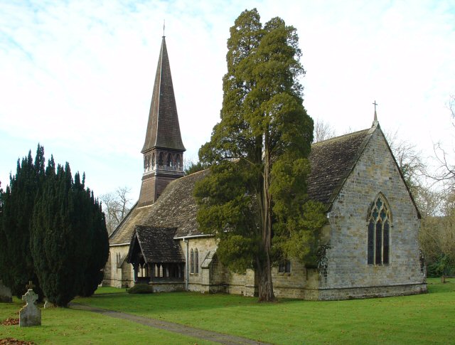
English: St Andrew's parish church, Nuthurst, West Sussex, seen from the southeast. There has been worship on this site since about AD 1130. The north chancel wall is 12th-century. The nave was built in the 14th century and extended in the 17th century. The wooden shingled spire was built in the late 19th-century. The vestry was added in about 1907. |
| Date | |
| Source | From geograph.org.uk |
| Author | Pete Chapman |
| Attribution (required by the license) | Pete Chapman / St Andrew's Church, Nuthurst, West Sussex / |
| Object location | | View this and other nearby images on: OpenStreetMap |
|---|
_&language=en)
Licensing
[edit]

|
This image was taken from the Geograph project collection. See this photograph's page on the Geograph website for the photographer's contact details. The copyright on this image is owned by Pete Chapman and is licensed for reuse under the Creative Commons Attribution-ShareAlike 2.0 license.
|
This file is licensed under the Creative Commons Attribution-Share Alike 2.0 Generic license.
Attribution: Pete Chapman
- You are free:
- to share – to copy, distribute and transmit the work
- to remix – to adapt the work
- Under the following conditions:
- attribution – You must give appropriate credit, provide a link to the license, and indicate if changes were made. You may do so in any reasonable manner, but not in any way that suggests the licensor endorses you or your use.
- share alike – If you remix, transform, or build upon the material, you must distribute your contributions under the same or compatible license as the original.
File history
Click on a date/time to view the file as it appeared at that time.
| Date/Time | Thumbnail | Dimensions | User | Comment | |
|---|---|---|---|---|---|
| current | 23:50, 30 January 2010 | | 640 × 485 (126 KB) | GeographBot (talk | contribs) | == {{int:filedesc}} == {{Information |description={{en|1=St Andrew's Church, Nuthurst, West Sussex. Parts of St Andrew's Church date back to the 12th century, namely the north chancel wall. The nave was built in the 14th century and extended in the 17th c |
You cannot overwrite this file.
File usage on Commons
There are no pages that use this file.
File usage on other wikis
The following other wikis use this file:
- Usage on en.wikipedia.org
- Usage on nl.wikipedia.org