File:St Andrew's Church, Chinnor, Oxfordshire 1.jpg
From Wikimedia Commons, the free media repository
Jump to navigation
Jump to search
![File:St Andrew's Church, Chinnor, Oxfordshire 1.jpg](https://upload.wikimedia.org/wikipedia/commons/thumb/c/c3/St_Andrew%27s_Church%2C_Chinnor%2C_Oxfordshire_1.jpg/450px-St_Andrew%27s_Church%2C_Chinnor%2C_Oxfordshire_1.jpg?20080503195254)
Size of this preview: 450 × 600 pixels. Other resolutions: 180 × 240 pixels | 480 × 640 pixels.
Original file (480 × 640 pixels, file size: 140 KB, MIME type: image/jpeg)
File information
Structured data
Captions
Captions
Add a one-line explanation of what this file represents
This is a photo of listed building number 1368881. |
Summary
[edit]DescriptionSt Andrew's Church, Chinnor, Oxfordshire 1.jpg |
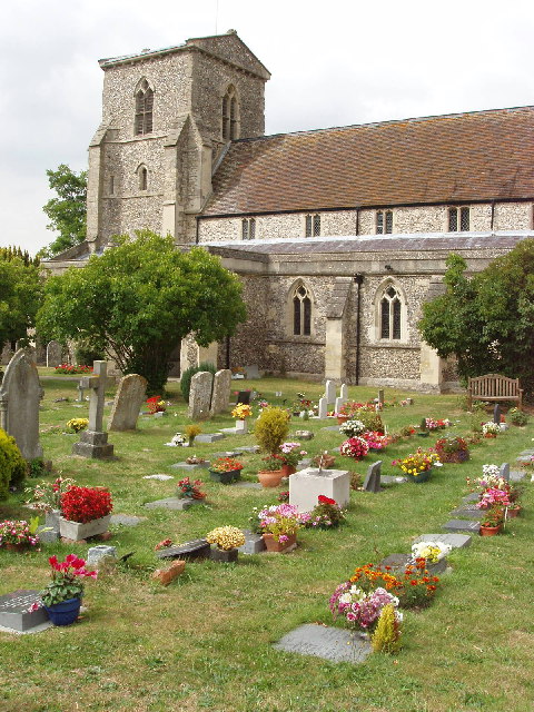
English: Nave and west tower of St Andrew's parish church, Chinnor, Oxfordshire, seen from the southeast |
||
Date | |||
Source | geograph.org.uk | ||
Author | David Hawgood | ||
Permission (Reusing this file) |
![]() ![]() ![]() This file is licensed under the Creative Commons Attribution-Share Alike 2.0 Generic license. Attribution: David Hawgood
|
Object location | 51° 42′ 05″ N, 0° 54′ 25″ W ![]() | View this and other nearby images on: OpenStreetMap | ![]() |
---|
File history
Click on a date/time to view the file as it appeared at that time.
Date/Time | Thumbnail | Dimensions | User | Comment | |
---|---|---|---|---|---|
current | 19:52, 3 May 2008 | ![]() | 480 × 640 (140 KB) | Polly (talk | contribs) | {{Information |Description=St Andrew's Church, Chinnor |Source=http://www.geograph.org.uk/photo/39209 |Date=Tuesday, 16 August, 2005 |Author=David Hawgood |Permission={{geograph|39209|David Hawgood}} |other_versions= }} Category:Geograph images [[Cat |
You cannot overwrite this file.
File usage on Commons
The following 2 pages use this file:
- File:Chinnor church.jpg (file redirect)
- Category:Chinnor
File usage on other wikis
The following other wikis use this file:
Metadata
This file contains additional information such as Exif metadata which may have been added by the digital camera, scanner, or software program used to create or digitize it. If the file has been modified from its original state, some details such as the timestamp may not fully reflect those of the original file. The timestamp is only as accurate as the clock in the camera, and it may be completely wrong.
Image title | OLYMPUS DIGITAL CAMERA |
---|---|
Camera manufacturer | OLYMPUS CORPORATION |
Camera model | X-3,C-60Z |
Exposure time | 1/500 sec (0.002) |
F-number | f/5.6 |
ISO speed rating | 200 |
Date and time of data generation | 15:38, 16 August 2005 |
Lens focal length | 7.8 mm |
Orientation | Normal |
Horizontal resolution | 200 dpi |
Vertical resolution | 200 dpi |
Software used | CAMEDIA Master 4.2 |
File change date and time | 19:04, 16 August 2005 |
Y and C positioning | Co-sited |
Exposure Program | Aperture priority |
Exif version | 2.21 |
Date and time of digitizing | 15:38, 16 August 2005 |
Meaning of each component |
|
APEX exposure bias | 0 |
Maximum land aperture | 3 APEX (f/2.83) |
Metering mode | Spot |
Light source | Unknown |
Flash | Flash did not fire, compulsory flash suppression |
Supported Flashpix version | 1 |
Color space | sRGB |
File source | Digital still camera |
Custom image processing | Custom process |
Exposure mode | Auto exposure |
White balance | Auto white balance |
Digital zoom ratio | 1 |
Scene capture type | Standard |
Scene control | High gain up |
Contrast | Normal |
Saturation | Normal |
Sharpness | Normal |
Structured data
Items portrayed in this file
depicts
16 August 2005
51°42'4.7"N, 0°54'25.2"W
0.002 second
5.6
7.8 millimetre
200
image/jpeg
Hidden categories:
- Listed buildings in England with known IDs
- CC-BY-SA-2.0
- Images from Geograph Britain and Ireland
- Images from Geograph Britain and Ireland missing SDC creator
- Images from Geograph Britain and Ireland missing SDC source of file
- Images from Geograph Britain and Ireland missing SDC coordinates of the point of view
- United Kingdom photographs taken on 2005-08-16
- Pages with maps