File:StBart quartiers 1801-2.jpg
Jump to navigation
Jump to search
Size of this preview: 762 × 600 pixels. Other resolutions: 305 × 240 pixels | 610 × 480 pixels | 976 × 768 pixels | 1,280 × 1,008 pixels | 2,312 × 1,820 pixels.
Original file (2,312 × 1,820 pixels, file size: 548 KB, MIME type: image/jpeg)
Captions
Captions
Add a one-line explanation of what this file represents
| Description |
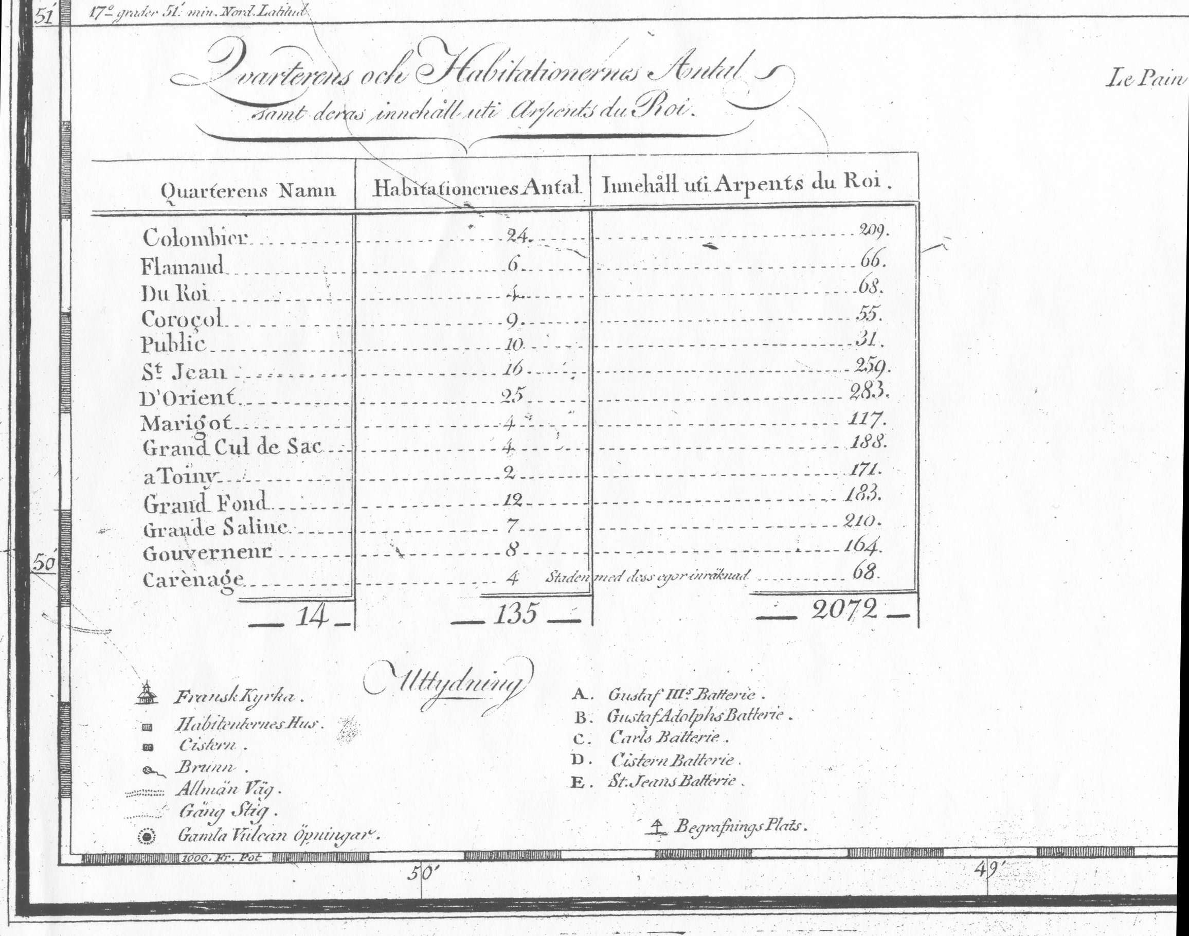
English: http://www.vobam.se/salda.htm St. Barthélemy (French island in the Caribbean) map of 1801, with quartier boundaries |
| Date | (UTC) |
| Source | |
| Author |
|
| This is a retouched picture, which means that it has been digitally altered from its original version. Modifications: more detailed scan of quartiers table. The original can be viewed here: StBart quartiers 1801.jpg:
|
|
This work is in the public domain in its country of origin and other countries and areas where the copyright term is the author's life plus 70 years or fewer. | |
| This file has been identified as being free of known restrictions under copyright law, including all related and neighboring rights. | |
Original upload log
[edit]
This image is a derivative work of the following images:
- File:StBart_quartiers_1801.jpg licensed with PD-old
- 2010-02-03T22:33:58Z Ratzer1 2163x1572 (466286 Bytes) {{Information |Description={{en|1=http://www.vobam.se/salda.htm St. Barthélemy (Frenche island in the Caribbean) map of 1801, with quartier boundaries}} |Source=http://www.vobam.se/Bilder/stbart.jpg |Author=unknown |Date=180
Uploaded with derivativeFX
File history
Click on a date/time to view the file as it appeared at that time.
| Date/Time | Thumbnail | Dimensions | User | Comment | |
|---|---|---|---|---|---|
| current | 22:26, 19 March 2010 | | 2,312 × 1,820 (548 KB) | Ratzer (talk | contribs) | {{Information |Description={{en|1=http://www.vobam.se/salda.htm St. Barthélemy (Frenche island in the Caribbean) map of 1801, with quartier boundaries}} |Source=*File:StBart_quartiers_1801.jpg |Date=2010-03-19 22:26 (UTC) |Author=*[[:File:StBart_qu |
You cannot overwrite this file.
File usage on Commons
There are no pages that use this file.
File usage on other wikis
The following other wikis use this file:
- Usage on de.wikipedia.org
- Usage on sv.wikipedia.org