File:St. Paul's Centre - geograph.org.uk - 1989097.jpg
Jump to navigation
Jump to search
Size of this preview: 800 × 531 pixels. Other resolutions: 320 × 212 pixels | 640 × 424 pixels | 1,024 × 679 pixels | 1,280 × 849 pixels | 1,600 × 1,061 pixels.
Original file (1,600 × 1,061 pixels, file size: 679 KB, MIME type: image/jpeg)
Captions
Captions
Add a one-line explanation of what this file represents
Summary
[edit]
| Description |
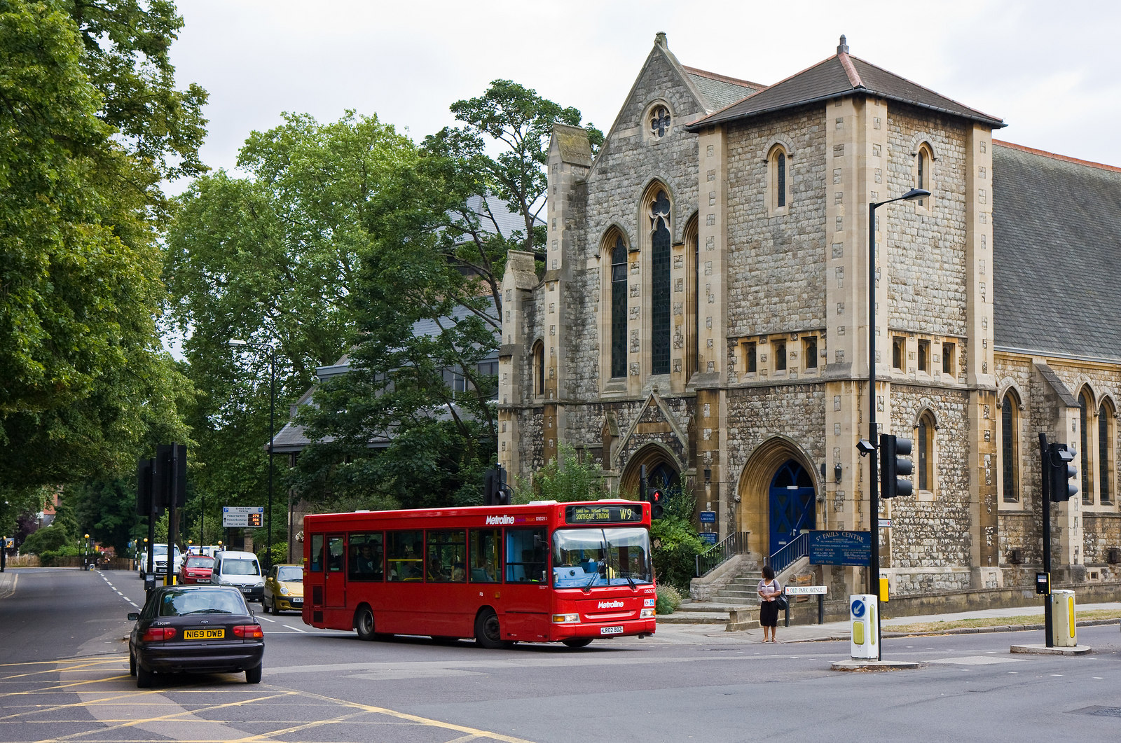
English: St. Paul's Centre, near to Forty Hill, Enfield, Great Britain.
A W9 bus, Metroline DSD211 (LR02 BDZ), passes the centre, turning left into Old Park Avenue from Church Street. St. Pauls was clearly once a major Presbyterian parish church seating around 500 people. Built in 1907 it was originally intended that it should have a spire but this was never completed and the building was left with a squat tower. The church is now a centre of many different activities including Enfield's counselling service and the local model railway club. However worship is still carried out here by the Chase Fellowship, an Evangelical group. |
| Date | |
| Source | From geograph.org.uk; transferred by User:oxyman using geograph_org2commons. |
| Author | Martin Addison |
| Permission (Reusing this file) |
Creative Commons Attribution Share-alike license 2.0 |
| Attribution (required by the license) | Martin Addison / St. Paul's Centre / |
| Camera location | | View this and other nearby images on: OpenStreetMap |
|---|
| Object location | | View this and other nearby images on: OpenStreetMap |
|---|
_region:GB-GBN_heading:157.00&language=en)
Licensing
[edit]

|
This image was taken from the Geograph project collection. See this photograph's page on the Geograph website for the photographer's contact details. The copyright on this image is owned by Martin Addison and is licensed for reuse under the Creative Commons Attribution-ShareAlike 2.0 license.
|
This file is licensed under the Creative Commons Attribution-Share Alike 2.0 Generic license.
Attribution: Martin Addison
- You are free:
- to share – to copy, distribute and transmit the work
- to remix – to adapt the work
- Under the following conditions:
- attribution – You must give appropriate credit, provide a link to the license, and indicate if changes were made. You may do so in any reasonable manner, but not in any way that suggests the licensor endorses you or your use.
- share alike – If you remix, transform, or build upon the material, you must distribute your contributions under the same or compatible license as the original.
File history
Click on a date/time to view the file as it appeared at that time.
| Date/Time | Thumbnail | Dimensions | User | Comment | |
|---|---|---|---|---|---|
| current | 20:31, 9 August 2010 | | 1,600 × 1,061 (679 KB) | File Upload Bot (Magnus Manske) (talk | contribs) | == {{int:filedesc}} == {{Information |Description={{en|1=St. Paul's Centre, near to Forty Hill, Enfield, Great Britain. A W9 bus passes the centre, turning left into Old Park Avenue from Church Street. St. Pauls was clearly once a major Presbyteria |
You cannot overwrite this file.
File usage on Commons
There are no pages that use this file.
File usage on other wikis
The following other wikis use this file:
- Usage on www.wikidata.org