File:St. David's Church at Llywel - geograph.org.uk - 1126233.jpg
Jump to navigation
Jump to search
No higher resolution available.
St._David's_Church_at_Llywel_-_geograph.org.uk_-_1126233.jpg (640 × 480 pixels, file size: 56 KB, MIME type: image/jpeg)
Captions
Captions
Add a one-line explanation of what this file represents
Summary
[edit]
| Description |
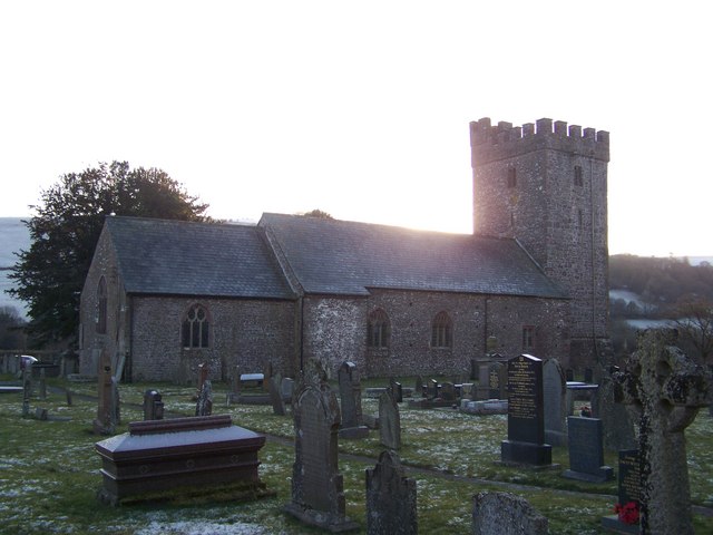
English: St. David's Church at Llywel St. David's Church stands in the extreme south-east of this grid-square at the foot of the military road leading onto the Epynt Ranges and can be seen from the A40. The current building is largely 15th Century, but contains earlier elements, including a pre-Norman font. According to legend, the church was founded in the sixth century by saint Llywel, a disciple of St. Teilo and was originally dedicated to Ss. David, Darn and Teilo. It is mentioned by Gerald of Wales for having been burnt down in the late twelfth century. |
| Date | |
| Source | From geograph.org.uk |
| Author | Dan Gregory |
| Attribution (required by the license) | Dan Gregory / St. David's Church at Llywel / |
| Camera location | | View this and other nearby images on: OpenStreetMap |
|---|
_heading:180.00&language=en)
| Object location | | View this and other nearby images on: OpenStreetMap |
|---|
_heading:180.00&language=en)
Licensing
[edit]

|
This image was taken from the Geograph project collection. See this photograph's page on the Geograph website for the photographer's contact details. The copyright on this image is owned by Dan Gregory and is licensed for reuse under the Creative Commons Attribution-ShareAlike 2.0 license.
|
This file is licensed under the Creative Commons Attribution-Share Alike 2.0 Generic license.
Attribution: Dan Gregory
- You are free:
- to share – to copy, distribute and transmit the work
- to remix – to adapt the work
- Under the following conditions:
- attribution – You must give appropriate credit, provide a link to the license, and indicate if changes were made. You may do so in any reasonable manner, but not in any way that suggests the licensor endorses you or your use.
- share alike – If you remix, transform, or build upon the material, you must distribute your contributions under the same or compatible license as the original.
File history
Click on a date/time to view the file as it appeared at that time.
| Date/Time | Thumbnail | Dimensions | User | Comment | |
|---|---|---|---|---|---|
| current | 01:35, 25 February 2011 | | 640 × 480 (56 KB) | GeographBot (talk | contribs) | == {{int:filedesc}} == {{Information |description={{en|1=St. David's Church at Llywel St. David's Church stands in the extreme south-east of this grid-square at the foot of the military road leading onto the Epynt Ranges and can be seen from the A40. The |
You cannot overwrite this file.
File usage on Commons
There are no pages that use this file.
File usage on other wikis
The following other wikis use this file: