File:Spurrell map Higham.jpg
Jump to navigation
Jump to search

Size of this preview: 701 × 599 pixels. Other resolutions: 281 × 240 pixels | 562 × 480 pixels | 898 × 768 pixels | 1,198 × 1,024 pixels | 1,874 × 1,602 pixels.
Original file (1,874 × 1,602 pixels, file size: 887 KB, MIME type: image/jpeg)
Captions
Captions
Add a one-line explanation of what this file represents
Summary
[edit]
| Description |
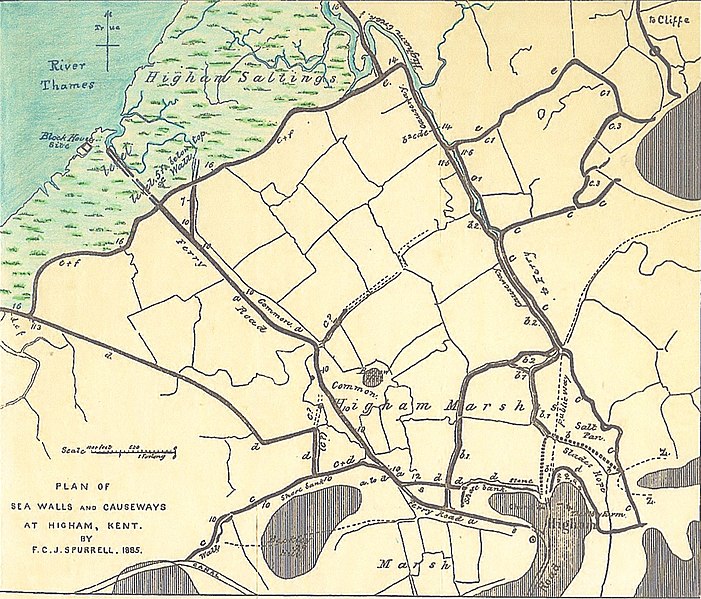
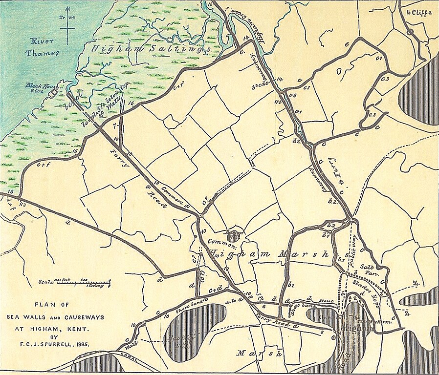
English: Plan of the sea walls and causeways at Higham, Kent, England drawn by Flaxman C.J. Spurrell, 1885. The spot heights of the walls are in feet A.O.D. The walls are labelled a to f from oldest to newest. The old walls are old tidal defences, now obsolete. The hatched areas are high ground. At high spring tide the River Thames deposits mud on the Saltings; hence they are growing marshes. Behind the walls the marshlands are no longer growing, and are agricultural land. |
| Date | |
| Source | Spurrell, F.C.J. (September 1885). "Early Sites and Embankments on the Margins of the Thames Estuary" . The Archaeological Journal: 269-303 |
| Author | F.C.J. Spurrell |
Licensing
[edit]
|
This work is in the public domain in its country of origin and other countries and areas where the copyright term is the author's life plus 70 years or fewer. This work is in the public domain in the United States because it was published (or registered with the U.S. Copyright Office) before January 1, 1929. | |
| This file has been identified as being free of known restrictions under copyright law, including all related and neighboring rights. | |
File history
Click on a date/time to view the file as it appeared at that time.
| Date/Time | Thumbnail | Dimensions | User | Comment | |
|---|---|---|---|---|---|
| current | 14:32, 9 December 2020 | | 1,874 × 1,602 (887 KB) | Ttocserp (talk | contribs) | Uploaded a work by F.C.J. Spurrell from Spurrell, F.C.J. (September 1885). "Early Sites and Embankments on the Margins of the Thames Estuary" . The Archaeological Journal: 269-303 with UploadWizard |
You cannot overwrite this file.
File usage on Commons
There are no pages that use this file.
File usage on other wikis
The following other wikis use this file:
- Usage on en.wikipedia.org