File:Springtime Thaw in Ungava Bay (MODIS 2022-06-06).jpg

Original file (2,360 × 1,906 pixels, file size: 838 KB, MIME type: image/jpeg)
Captions
Captions
Summary
[edit].jpg&action=edit§ion=1)
| Description |
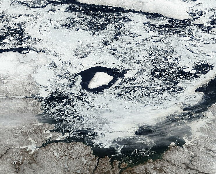
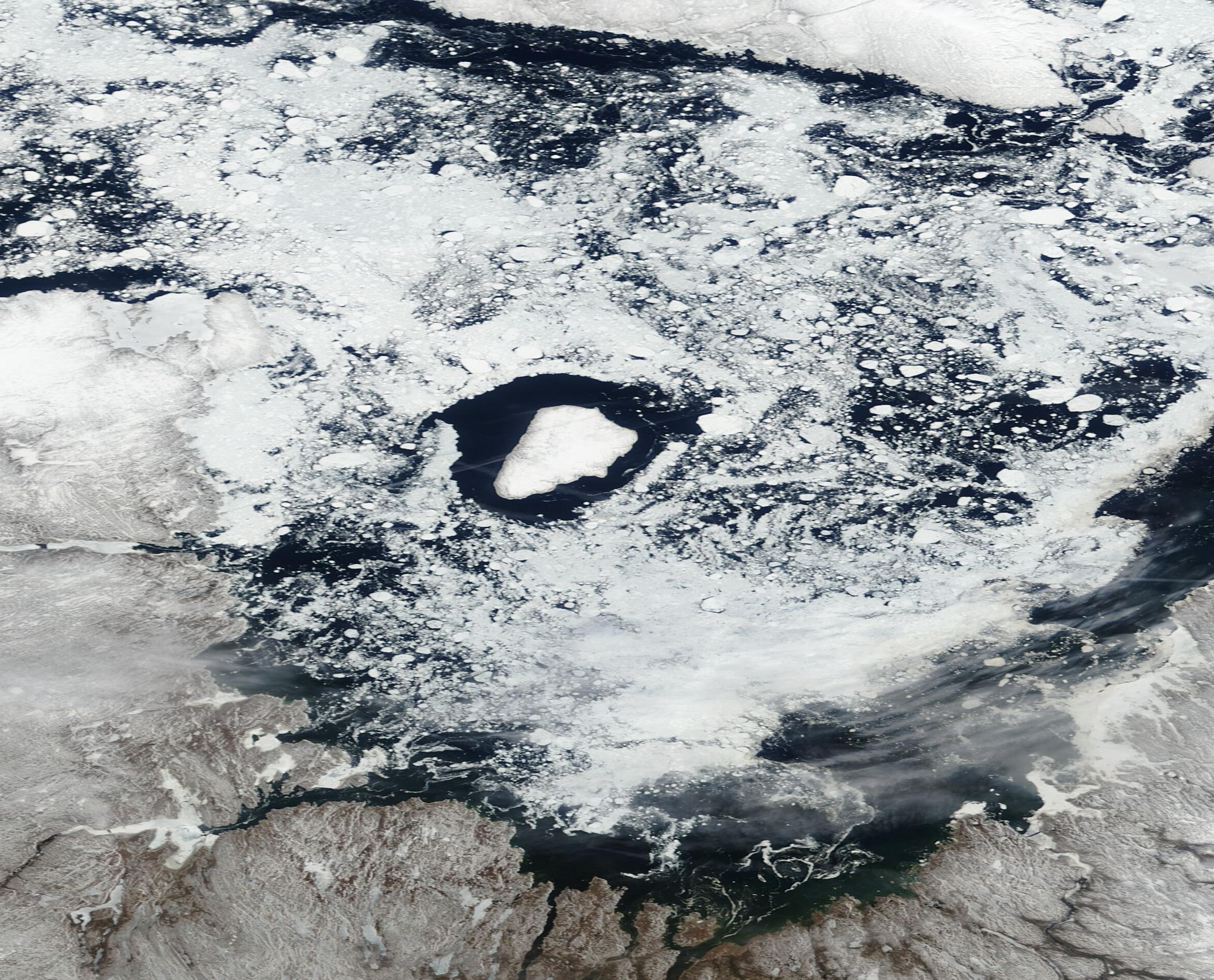
English: Sitting along the northern coastline of Quebec, Canada, Ungava Bay is a funnel-shaped, shallow body of water that lies south of the Hudson Strait, east of the Ungava Peninsula, and west of the Torngat Mountains. Thanks to its northern location, ice begins to form on Ungava Bay in November and typically stays through June. Because the chilly waters remain ice-free in the summer and early fall, the copious ice that covers the Bay in winter is first-year ice and, thanks to the extremely high tides and strong currents, the ice tends to be “rubble” ice— a type of ice made up of a jumble of ice fragments that cover the water without any particular order.
On June 2, 2022, the Moderate Resolution Imaging Spectroradiometer (MODIS) on board NASA’s Terra satellite acquired a true-color image of ice on Ungava Bay. In the image, a thin layer of winter’s snow and ice still covers the mainland of Quebec (south) while, to the north, Baffin Island wears a mantle of winter white. Some fast ice (ice connected to the shoreline) remains and copious rubble ice floats on the waters of the Bay, but large areas of open water are visible off most of the coastal areas and around Akpatok Island, in the center of the image. Accessible only by air, Akpatok Island rises out of the water as sheer cliffs that soar 500 to 800 feet (150 to 243 meters) above the sea surface. The island is an important sanctuary for cliff-nesting seabirds. In the winter, numerous ice floes around the island attract walruses and whales, making Akpatok a traditional hunting ground for native Inuit people. |
||
| Date | Taken on 2 June 2022 | ||
| Source |
Springtime Thaw in Ungava Bay (direct link)
|
||
| Author | MODIS Land Rapid Response Team, NASA GSFC |
| This media is a product of the Terra mission Credit and attribution belongs to the mission team, if not already specified in the "author" row |
Licensing
[edit].jpg&action=edit§ion=2)
| This file is in the public domain in the United States because it was solely created by NASA. NASA copyright policy states that "NASA material is not protected by copyright unless noted". (See Template:PD-USGov, NASA copyright policy page or JPL Image Use Policy.) | ||
 |
Warnings:
|
File history
Click on a date/time to view the file as it appeared at that time.
| Date/Time | Thumbnail | Dimensions | User | Comment | |
|---|---|---|---|---|---|
| current | 22:02, 9 January 2024 | | 2,360 × 1,906 (838 KB) | OptimusPrimeBot (talk | contribs) | #Spacemedia - Upload of http://modis.gsfc.nasa.gov/gallery/images/image06062022_250m.jpg via Commons:Spacemedia |
You cannot overwrite this file.
File usage on Commons
There are no pages that use this file.
.jpg&oldid=909384615)