File:Spittal Drau Lieser Goldeck Millstättersee 01.JPG
Jump to navigation
Jump to search
Size of this preview: 800 × 600 pixels. Other resolutions: 320 × 240 pixels | 640 × 480 pixels | 1,024 × 768 pixels | 1,280 × 960 pixels | 2,272 × 1,704 pixels.
Original file (2,272 × 1,704 pixels, file size: 960 KB, MIME type: image/jpeg)
Captions
Captions
Add a one-line explanation of what this file represents
Summary
[edit]
| Description |
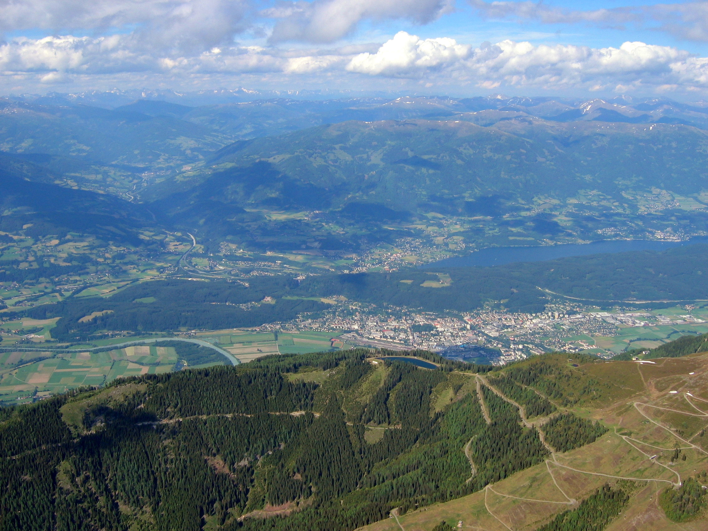
Deutsch: Luftaufnahme auf der Höhe des Goldecks in Kärnten / Österreich / EU) aus einem Segelflugzeug (Diskus 2) Richtung Norden. Im Vordergrund der Kaisergraben mit Plattenhöhe, rechts der ansteigende Gipfelbereich des Goldecks. Dahinter das Untere Drautal, links mit einer Schleife der Drau, in der Mitte mit der Bezirkshauptstadt Spittal an der Drau. Dahinter von links nach rechts der Millstätter See-Rücken. Aus dem Liesertal in der linken Bildhäfte kommt die Tauern Autobahn (A10). Im linken Bereich beginnen die ansteigenden Hohen Tauern mit dem Gmeineck, an dessen Fußbereich Hirschberg oder Hühnersberg heißt. Links von der in der Bildmitte liegenden Ortschaft Seeboden das Autobahnkreuz Lieserhofen, rechts der Millstätter See hinüber bis Millstatt. Darüber der westliche Teil des Millstätter Bergs ganz rechts mit Obermillstatt. Zwischen Liesertal und Millstätter See liegt der südwestliche Teil der Nockberge.
English: Lower valley of the Drava at the height of Lake Millstatt near Spittal an der Drau / Carinthia / Austria / EU. Seen from a glider (Diskus 2). Photograph at the height of Goldeck. |
| Date | |
| Source | Own work |
| Author | Joadl (all honors to CLK) |
| Camera location | | View this and other nearby images on: OpenStreetMap |
|---|
Licensing
[edit]
I, the copyright holder of this work, hereby publish it under the following licenses:

|
Permission is granted to copy, distribute and/or modify this document under the terms of the GNU Free Documentation License, Version 1.2 or any later version published by the Free Software Foundation; with no Invariant Sections, no Front-Cover Texts, and no Back-Cover Texts. A copy of the license is included in the section entitled GNU Free Documentation License. |
This file is licensed under the Creative Commons Attribution-Share Alike 3.0 Unported, 2.5 Generic, 2.0 Generic and 1.0 Generic license.
- You are free:
- to share – to copy, distribute and transmit the work
- to remix – to adapt the work
- Under the following conditions:
- attribution – You must give appropriate credit, provide a link to the license, and indicate if changes were made. You may do so in any reasonable manner, but not in any way that suggests the licensor endorses you or your use.
- share alike – If you remix, transform, or build upon the material, you must distribute your contributions under the same or compatible license as the original.
You may select the license of your choice.
File history
Click on a date/time to view the file as it appeared at that time.
| Date/Time | Thumbnail | Dimensions | User | Comment | |
|---|---|---|---|---|---|
| current | 22:39, 27 November 2009 | | 2,272 × 1,704 (960 KB) | Joadl (talk | contribs) | {{Information |Description= {{de|Nockberge, Spittal / Drau, Millstätter See und Unteres Drautal (Kärnten / Österreich / EU) aus einem Segelflugzeug (Diskus 2). Aufnahme auf |
You cannot overwrite this file.
File usage on Commons
The following 4 pages use this file: