File:Soviet Navy Bases 1984.png
Jump to navigation
Jump to search
Size of this preview: 800 × 370 pixels. Other resolutions: 320 × 148 pixels | 640 × 296 pixels | 1,357 × 628 pixels.
Original file (1,357 × 628 pixels, file size: 41 KB, MIME type: image/png)
Captions
Captions
Add a one-line explanation of what this file represents
| Description |
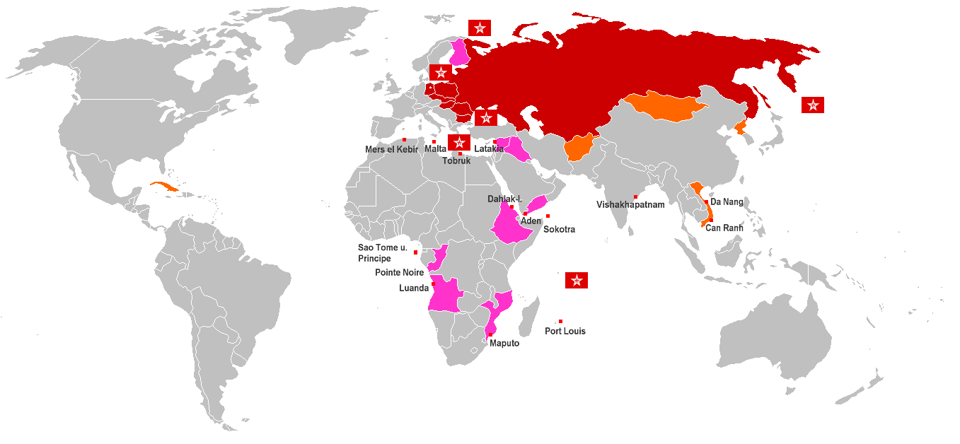
English: World Map of Soviet Navy Bases and anchor rights (red cubes with name). Red countries are Warsaw Pact member states, Orange countries are States with special treaty of mutual assistance and friendship with the Soviet Union, Pink countries are States with special treaty of mutual assistance and friendship since 1970, Flags are Fleets of the Soviet Navy Deutsch: Weltkarte der sowjetischen Marinebasen und Ankerrechte (roter Würfel). Rot eingefärbte Länder sind Warschauer Pakt-Staaten, orange eingefärbte sind Staaten mit einem Freundschafts- und Beistandsabkommen mit besonderer Bindung zur Sowjetunion, rosa eingefärbte Länder sind Staaten mit sonstige Freundschafts- und Beistandsabkommen, bzw. Militärhilfeabkommen ab 1970, Gösch-Flaggen sind Flotten und Detachements der Sowjetischen Marine (Nordmeerflotte, Baltische Flotte, Schwarzmeer-Flotte, Pazifikflotte und Detachements im Mittelmeer (Eskadra) und im Indischen Ozean |
| Date | |
| Source | Own work |
| Author | Wikifreund, Germany |
| Permission (Reusing this file) |
This file is licensed under the Creative Commons Attribution 2.0 Generic license.
|
File history
Click on a date/time to view the file as it appeared at that time.
| Date/Time | Thumbnail | Dimensions | User | Comment | |
|---|---|---|---|---|---|
| current | 02:05, 17 February 2009 | | 1,357 × 628 (41 KB) | Disposable.Heroes (talk | contribs) | pngcrush |
| 21:08, 10 October 2008 |  | 1,357 × 628 (55 KB) | Milosevo (talk | contribs) | {{Information |Description= |Source= |Date= |Author= |Permission= |other_versions= }} | |
| 11:05, 25 July 2007 |  | 1,357 × 628 (46 KB) | Wikifreund (talk | contribs) | {{Information |Description={{en|World Map of Soviet Navy Bases and anchor rights (= red cubes with name). Red countries = Warsaw Pact member states, Orange countries = States with special treaty of mutual assistance and friendship with the Soviet Union, P |
You cannot overwrite this file.
File usage on Commons
There are no pages that use this file.
File usage on other wikis
The following other wikis use this file:
- Usage on ba.wikipedia.org
- Usage on be-tarask.wikipedia.org
- Usage on be.wikipedia.org
- Usage on bg.wikipedia.org
- Usage on ca.wikipedia.org
- Usage on cs.wikipedia.org
- Usage on da.wikipedia.org
- Usage on de.wikipedia.org
- Usage on en.wikipedia.org
- Usage on es.wikipedia.org
- Usage on fi.wikipedia.org
- Usage on fr.wikipedia.org
- Usage on it.wikipedia.org
- Usage on ja.wikipedia.org
- Usage on ko.wikipedia.org
- Usage on ru.wikipedia.org
- Usage on tr.wikipedia.org
- Usage on uk.wikipedia.org
- Usage on www.wikidata.org
- Usage on zh.wikipedia.org