File:Southern edge of Pitts Wood Inclosure, New Forest - geograph.org.uk - 478147.jpg
Jump to navigation
Jump to search
No higher resolution available.
Southern_edge_of_Pitts_Wood_Inclosure,_New_Forest_-_geograph.org.uk_-_478147.jpg (640 × 427 pixels, file size: 77 KB, MIME type: image/jpeg)
Captions
Captions
Add a one-line explanation of what this file represents
Summary
[edit]
| Description |
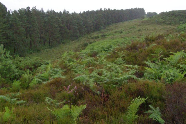
English: Southern edge of Pitts Wood Inclosure, New Forest This line of conifers marks the southern edge of Pitts Wood Inclosure, a plantation first established (with oak) in 1775. The Ashley Cross plateau is off to the right, with Ashley Bottom and Must Thorns Bottom off to the left. There are several bomb craters on this damp heathy slope, a result of stray bombs that missed their range targets up on the plateau during the Second World War. There is a particularly large one at SU19691426, just above the centre of this photo, surrounded by bracken. The low light and poor visibility in this photo is due to heavy rain. |
| Date | |
| Source | From geograph.org.uk |
| Author | Jim Champion |
| Attribution (required by the license) | Jim Champion / Southern edge of Pitts Wood Inclosure, New Forest / |
| Camera location | | View this and other nearby images on: OpenStreetMap |
|---|
_heading:67.00&language=en)
| Object location | | View this and other nearby images on: OpenStreetMap |
|---|
_heading:67.00&language=en)
Licensing
[edit]

|
This image was taken from the Geograph project collection. See this photograph's page on the Geograph website for the photographer's contact details. The copyright on this image is owned by Jim Champion and is licensed for reuse under the Creative Commons Attribution-ShareAlike 2.0 license.
|
This file is licensed under the Creative Commons Attribution-Share Alike 2.0 Generic license.
Attribution: Jim Champion
- You are free:
- to share – to copy, distribute and transmit the work
- to remix – to adapt the work
- Under the following conditions:
- attribution – You must give appropriate credit, provide a link to the license, and indicate if changes were made. You may do so in any reasonable manner, but not in any way that suggests the licensor endorses you or your use.
- share alike – If you remix, transform, or build upon the material, you must distribute your contributions under the same or compatible license as the original.
File history
Click on a date/time to view the file as it appeared at that time.
| Date/Time | Thumbnail | Dimensions | User | Comment | |
|---|---|---|---|---|---|
| current | 23:22, 4 February 2011 | | 640 × 427 (77 KB) | GeographBot (talk | contribs) | == {{int:filedesc}} == {{Information |description={{en|1=Southern edge of Pitts Wood Inclosure, New Forest This line of conifers marks the southern edge of Pitts Wood Inclosure, a plantation first established (with oak) in 1775. The Ashley Cross plateau i |
You cannot overwrite this file.
File usage on Commons
There are no pages that use this file.