File:Southern South America (MODIS 2017-02-03).jpg

Original file (7,200 × 9,400 pixels, file size: 10.89 MB, MIME type: image/jpeg)
Captions
Captions
Summary
[edit].jpg&action=edit§ion=1)
| Description |
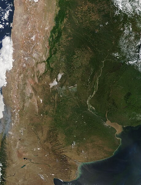
English: On January 29, 2017, NASA’s Terra satellite flew over southern South America, allowing the Moderate Resolution Imaging Spectroradiometer (MODIS) flying aboard to capture a true-color image of the sunny summer landscape of the region.
The image is centered near the nearly-round saline lake called Mar Chiquita which is located in the green pampas of central Argentina. To the northeast lie two large salt flats which appear white in color. Lagos Salinas Grandes is the more southerly of the two, while Lagos Salinas de Ambargasta is the more northerly. The rugged Andes Mountains lie west of the salt flats and mark a boundary between Argentina and Chile. Low cloud (fog) lies over parts of coastal Chile. In the east, the sediment-filled Parana River meanders through the pampas of Argentina to the Rio de la Plata, the funnel-shaped estuary that separates Argentina from Uruguay. Further east, the tan-colored waters of the Uruguay River form an inland boundary between Uruguay and Argentina then flow directly into the northern tip of the Rio de la Plata. Both the Parana and Uruguay Rivers spill their sediment into the Rio de la Plata, enhancing the muddy-tan color of the estuary as well as the waters of the South Atlantic Ocean just offshore. The gray pixels on the southern shore of the Rio de la Plata mark the city of Buenos Aires, Argentina while a smaller area of gray on the northeastern shore represents the city of Montevideo, Uruguay. |
||
| Date | Taken on 29 January 2017 | ||
| Source |
Southern South America (direct link)
|
||
| Author | Jeff Schmaltz, MODIS Land Rapid Response Team, NASA GSFC |
| This media is a product of the Terra mission Credit and attribution belongs to the mission team, if not already specified in the "author" row |
Licensing
[edit].jpg&action=edit§ion=2)
| This file is in the public domain in the United States because it was solely created by NASA. NASA copyright policy states that "NASA material is not protected by copyright unless noted". (See Template:PD-USGov, NASA copyright policy page or JPL Image Use Policy.) | ||
 |
Warnings:
|
File history
Click on a date/time to view the file as it appeared at that time.
| Date/Time | Thumbnail | Dimensions | User | Comment | |
|---|---|---|---|---|---|
| current | 19:09, 16 February 2024 | | 7,200 × 9,400 (10.89 MB) | OptimusPrimeBot (talk | contribs) | #Spacemedia - Upload of http://modis.gsfc.nasa.gov/gallery/images/image02032017_250m.jpg via Commons:Spacemedia |
You cannot overwrite this file.
File usage on Commons
There are no pages that use this file.
.jpg&oldid=852929748)