File:Southeastern USA at Night - NASA Earth Observatory.jpg
Southeastern_USA_at_Night_-_NASA_Earth_Observatory.jpg (720 × 480 pixels, file size: 105 KB, MIME type: image/jpeg)
Captions
Captions
Summary
[edit]
| Description |
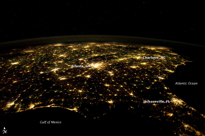
To download the full resolution and other files go to: earthobservatory.nasa.gov/IOTD/view.php?id=77146&src=... The southern United States is known for its distinctive cultural and historical identity within the country, including distinct music, cuisine, literature, and social customs. The U.S. Census Bureau defines “The South” as including the states of Alabama, Arkansas, Delaware, Florida, Georgia, Kentucky, Louisiana, Maryland, Mississippi, North Carolina, Oklahoma, South Carolina, Tennessee, Texas, Virginia, and West Virginia. This astronaut photograph from the International Space Station highlights the southeastern part of the South at night, including the eastern Gulf of Mexico and lower Atlantic Seaboard states. The view is part of a time-lapse series of images that extends from just southwest of Mexico to northeast of Newfoundland, Canada. New sequences from the Space Station are regularly posted on the Crew Earth Observation videos page. Following the American Civil War (1861-1865), the southern U.S. continued to be mostly agrarian until the latter half of the 20th century, when increased migration from other areas of the country and immigration from outside the U.S. led to increased urbanization. The brightly lit metropolitan areas of Atlanta, Georgia (image center) and Jacksonville, Florida (image lower right) appear largest in the image, with numerous other urban areas forming an interconnected network of light across the region. A large dark region to the northwest of Jacksonville is the Okefenokee National Wildlife Refuge. Likewise, the ridges of the Appalachian Mountains form dark swaths to the north of Atlanta and west of Charlotte, North Carolina (image center). The faint gold and green line of airglow—caused by ultraviolet radiation exciting the gas molecules in the upper atmosphere—parallels the horizon (or Earth limb). Astronaut photograph ISS030-E-55569 was acquired on January 29, 2012, with a Nikon D3S digital camera using a 24 mm lens, and is provided by the ISS Crew Earth Observations experiment and Image Science & Analysis Laboratory, Johnson Space Center. The image was taken by the Expedition 30 crew. The image has been cropped and enhanced to improve contrast, and lens artifacts have been removed. The International Space Station Program supports the laboratory as part of the ISS National Lab to help astronauts take pictures of Earth that will be of the greatest value to scientists and the public, and to make those images freely available on the Internet. Additional images taken by astronauts and cosmonauts can be viewed at the NASA/JSC Gateway to Astronaut Photography of Earth. Caption by William L. Stefanov, Jacobs Technology/ESCG at NASA-JSC. |
| Date | |
| Source | Southeastern USA at Night |
| Author | NASA's Earth Observatory |
| Camera location | | View this and other nearby images on: OpenStreetMap |
|---|
Licensing
[edit]
- You are free:
- to share – to copy, distribute and transmit the work
- to remix – to adapt the work
- Under the following conditions:
- attribution – You must give appropriate credit, provide a link to the license, and indicate if changes were made. You may do so in any reasonable manner, but not in any way that suggests the licensor endorses you or your use.
| This image was originally posted to Flickr by NASA Earth Observatory at https://www.flickr.com/photos/68824346@N02/6870004191. It was reviewed on 2 July 2012 by FlickreviewR and was confirmed to be licensed under the terms of the cc-by-2.0. |
File history
Click on a date/time to view the file as it appeared at that time.
| Date/Time | Thumbnail | Dimensions | User | Comment | |
|---|---|---|---|---|---|
| current | 17:10, 2 July 2012 | | 720 × 480 (105 KB) | Dzlinker (talk | contribs) | == {{int:filedesc}} == {{Information |Description=To download the full resolution and other files go to: [http://earthobservatory.nasa.gov/IOTD/view.php?id=77146&src=flickr earthobservatory.nasa.gov/IOTD/view.php?id=77146&src=...] The southern United ... |
You cannot overwrite this file.
File usage on Commons
The following page uses this file:
- File:Southeastern USA at Night (6870004191).jpg (file redirect)
.jpg&redirect=no)