File:Southeast tip of Guadalcanal - crop of Guadalcanal and Savo1958 topo map nla.obj-540256336.jpg
Jump to navigation
Jump to search

Size of this preview: 415 × 599 pixels. Other resolutions: 166 × 240 pixels | 332 × 480 pixels | 532 × 768 pixels | 709 × 1,024 pixels | 1,419 × 2,048 pixels | 2,667 × 3,849 pixels.
Original file (2,667 × 3,849 pixels, file size: 2.4 MB, MIME type: image/jpeg)
Captions
Captions
Add a one-line explanation of what this file represents
Summary
[edit]| Description |
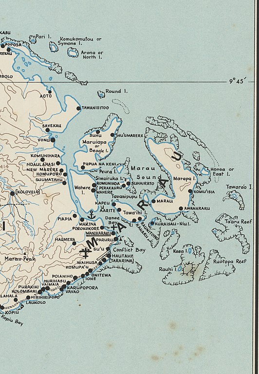
Deutsch: Topographic map of Guadalcanal Island, inset of Savo Island, Solomon Islands, Melanesia, South Pacific Ocean. Map size 54 x 101 cm., on sheet 59 x 107 cm. |
| Date | |
| Source | https://nla.gov.au/nla.obj-540256336/view |
| Author | Departments of Geological Surveys and Lands & Surveys |
| Other versions |

Licensing
[edit]
This work created by the United Kingdom Government is in the public domain.
This is because it is one of the following:
HMSO has declared that the expiry of Crown Copyrights applies worldwide (ref: HMSO Email Reply)
|
 |
File history
Click on a date/time to view the file as it appeared at that time.
| Date/Time | Thumbnail | Dimensions | User | Comment | |
|---|---|---|---|---|---|
| current | 10:22, 28 July 2019 | | 2,667 × 3,849 (2.4 MB) | Ratzer (talk | contribs) | File:Guadalcanal and Savo1958 topo map nla.obj-540256336.jpg cropped 89 % horizontally, 73 % vertically using CropTool with precise mode. |
You cannot overwrite this file.
File usage on Commons
The following page uses this file:
File usage on other wikis
The following other wikis use this file:
- Usage on de.wikipedia.org