File:Southeast Namibia ESA390746.jpg

Original file (6,547 × 4,605 pixels, file size: 9.15 MB, MIME type: image/jpeg)
Captions
Captions
Summary
[edit]| Description |
Afrikaans: Wat na die oppervlak van Mars mag lyk, is eintlik die westelike rand van die Kalahari-woestyn in die suidooste van Namibië, soos vasgelê deur die aardsatelliet Copernicus Sentinel-2. Namibië is nie slegs vir pragtige woestynlandvorme bekend nie, maar ook om die leidrade wat hierdie woestyne bied vir naspeuring van die historiese verloop van lokale tektoniese plaatbeweging. Die Namibwoestyn, wat langs Afrika se suidwestelike kus loop, is na bewering die oudste woestyn ter wêreld. Hierdie beeld is egter verder oos geneem – oor 'n deel van suidoostelike Namibië – en die treffende oranje-rooi kleure is eweneens te danke aan die semi-droë klimaat van hierdie afgeleë streek. Die Kalahari, wat 'n groot deel van Botswana, dele van Suid-Afrika en 'n deel van suidoostelike Namibië beslaan, is nie 'n ware woestyn nie aangesien dit te veel reën ontvang. Nogtans is dit 'n gebied met antieke gefossileerde sandduine of sogenaamde sandplate waarvan sommige sigbaar oor die regter boonste hoek van die beeld loop. Hierdie tans onbeweeglike duine lyk verbasend ewewydig en eenvormig en het vermoedelik tussen 2 500 000 en 12 000 jaar gelede gevorm. Na die ooste lyk die landskap ook soos 'n eksotiese oranje wêreld en word oorheers deur rante, platorande en droë soutpanne. Paaie wat skerp oor die landskap sny herinner dat hierdie streek nie heeltemal onbevolk is nie. Hierdie beeld, wat ook op die Earth from Space-videoprogram verskyn, is op 28 Julie 2017 deur Sentinel-2 vasgelê.
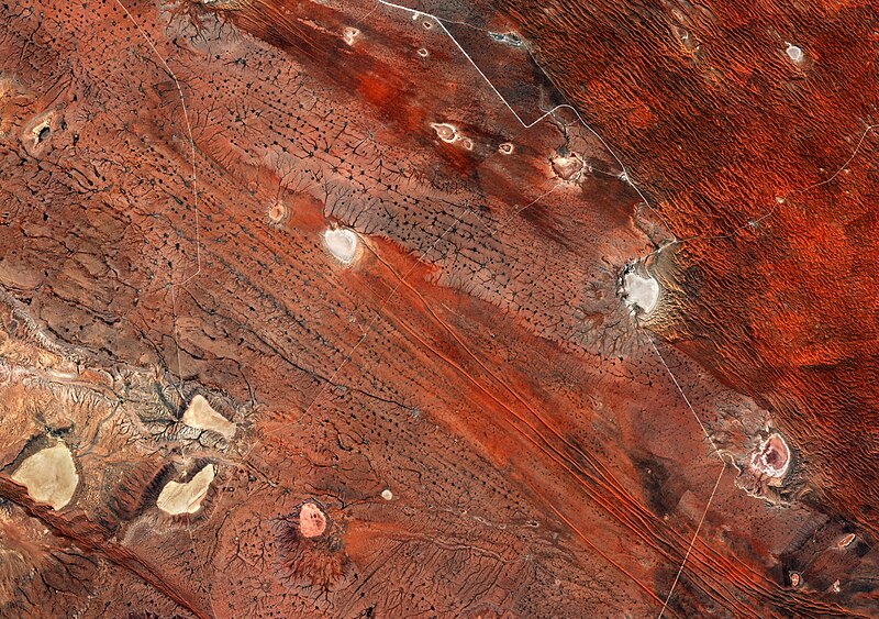
English: Although this image might look more like the surface of Mars, it was actually captured by the Copernicus Sentinel-2 mission and shows southeast Namibia and the western edge of the Kalahari Desert.
Namibia is famous not only for its stunning desert landforms but also because these deserts offer clues to the history of tectonic plate movement in this part of Africa. The Namib Desert, which runs along Africa’s southwestern coast, is said to be the oldest desert in the world. While this image was taken further east – over part of southeast Namibia – the striking orange–russet tones are also down to the semi-arid climate in this remote region. The Kalahari, which covers much of Botswana, parts of South Africa and part of southeast Namibia is not a true desert as it receives too much rain, but it is an area of ancient fossilised sand dunes. Some of these dunes, also known as sand sheets, can be seen running across the top-right corner of the image and appear surprisingly parallel and uniform. It is thought that these dunes formed between 2 500 000 and 12 000 years ago, and have been fixed ever since. To the east, the landscape also looks like an alien orange world and is dominated by ridges, escarpments and dry lake beds known as salt pans. Roads cutting sharply across the landscape are a reminder that this region is not entirely unpopulated. The image, which is also featured on theEarth from Space video programme, was captured by Sentinel-2 on 28 July 2017. |
| Date | |
| Source | http://www.esa.int/spaceinimages/Images/2018/03/Southeast_Namibia |
| Author | European Space Agency |
| Permission (Reusing this file) |
contains modified Copernicus Sentinel data (2017), processed by ESA,CC BY-SA 3.0 IGO |
| Other versions |
|
| Title | Southeast Namibia |
| System | Copernicus |
| Set | Earth observation image of the week |
| Location | Namibia |
| Mission | Sentinel-2 |
| Activity | Observing the Earth |
Licensing
[edit]
- You are free:
- to share – to copy, distribute and transmit the work
- to remix – to adapt the work
- Under the following conditions:
- attribution – You must give appropriate credit, provide a link to the license, and indicate if changes were made. You may do so in any reasonable manner, but not in any way that suggests the licensor endorses you or your use.
- share alike – If you remix, transform, or build upon the material, you must distribute your contributions under the same or compatible license as the original.

|
This image contains data from a satellite in the Copernicus Programme, such as Sentinel-1, Sentinel-2 or Sentinel-3. Attribution is required when using this image.
Attribution: Contains modified Copernicus Sentinel data {{{year}}}
The use of Copernicus Sentinel Data is regulated under EU law (Commission Delegated Regulation (EU) No 1159/2013 and Regulation (EU) No 377/2014). Relevant excerpts:
Free access shall be given to GMES dedicated data [...] made available through GMES dissemination platforms [...].
Access to GMES dedicated data [...] shall be given for the purpose of the following use in so far as it is lawful:
GMES dedicated data [...] may be used worldwide without limitations in time.
GMES dedicated data and GMES service information are provided to users without any express or implied warranty, including as regards quality and suitability for any purpose. |
File history
Click on a date/time to view the file as it appeared at that time.
| Date/Time | Thumbnail | Dimensions | User | Comment | |
|---|---|---|---|---|---|
| current | 16:12, 14 July 2022 | | 6,547 × 4,605 (9.15 MB) | Don-vip (talk | contribs) | full-res version from the TIFF file |
| 16:57, 2 March 2018 |  | 2,000 × 1,407 (2.18 MB) | Fæ (talk | contribs) | European Space Agency, Id 390746, http://www.esa.int/spaceinimages/Images/2018/03/Southeast_Namibia, User:Fæ/Project_list/ESA |
You cannot overwrite this file.
File usage on Commons
The following 2 pages use this file:
.jpg&redirect=no)