File:Southeast Missouri Lead District - subdistricts map.svg
Original file (SVG file, nominally 868 × 730 pixels, file size: 302 KB)
Captions
Contents
- 1 Summary
- 2 Licensing
- 2.1 Potosi
- 2.2 Ste. Genevieve
- 2.3 Herculaneum
- 2.4 Bonne Terre
- 2.5 Old Mines
- 2.6 Park Hills
- 2.7 Ironton
- 2.8 St. Francois Mountains
- 2.9 Subdistricts
- 2.10 Viburnum Mine #29
- 2.11 Viburnum Mine #27
- 2.12 Viburnum Mine #28 and Central Mill
- 2.13 Casteel Mine
- 2.14 Magmont Mine
- 2.15 Buick Mine and Mill
- 2.16 Buick Resource Recovery Facility
- 2.17 Brushy Creek Mine and Mill
- 2.18 West Fork Mine and Mill
- 2.19 Fletcher Mine and Mill
- 2.20 Sweetwater Mine
- 2.21 Indian Creek Mine
- 2.22 Viburnum Trend
- 2.23 Valles Mines
- 2.24 Irondale
- 2.25 Annapolis
Summary
[edit]DescriptionSoutheast Missouri Lead District - subdistricts map.svg |
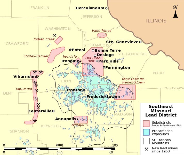
English: This is a map showing subdistricts of the Southeast Missouri Lead District and the locations of mines opened since 1953, some now closed, all on the west side of the district. The Indian Creek Mine opened in 1953 following exploration for new deposits to replace those being depleted in the Old Lead Belt, and development of the Viburnum Trend subdistrict followed. Six mines of the Doe Run Company are active as of 2010 according to the company's website.[1]
Boundaries of the subdistricts were taken from USGS Scientific Investigations Report 2008-5140 which cites Snyder, F.G., and Gerdemann, P.E., 1968, Geology of the Southeast Missouri Lead District, in Ridge, J.D., ed., Ore deposits of the United States, 1933-1967: New York, The American Institute of Mining Metallurgical and Petroleum Engineers, Inc., p. 327-358. Locations of mines taken from Inventory of Mines, Occurrences, and Prospects in Missouri, Missouri Department of Natural Resources (MoDNR), Division of Geology and Land Survey (DGLS), Geological Survey Program (GSP) 2008-01-10. Digital vector data Map projection: UTM Zone 15N |
Date | |
Source | Own work |
Author | Kbh3rd |
Licensing
[edit]- You are free:
- to share – to copy, distribute and transmit the work
- to remix – to adapt the work
- Under the following conditions:
- attribution – You must give appropriate credit, provide a link to the license, and indicate if changes were made. You may do so in any reasonable manner, but not in any way that suggests the licensor endorses you or your use.
- share alike – If you remix, transform, or build upon the material, you must distribute your contributions under the same or compatible license as the original.
Annotations InfoField | This image is annotated: View the annotations at Commons |
Potosi
[edit]Philippe Francois Renault brought slave labor from Santo Domingo to the Potosi area to mine surface and near-surface ores in 1721. Moses Austin settled here in 1799 and started the first underground lead mine in Missouri with a shaft sunk to 80 feet (24m). He brought improved mining and extraction techniques and built the region's first reverbratory furnace for smelting ore in 1802. Moses Austin, who later pioneered American settlement in Texas and for whom Austin, Texas, is named, is buried in Potosi.
Mine LaMotte was the earliest or one of the earliest productive lead mines in Missouri, depending on the source, as early as 1721. It was worked intermittently for 238 yeas until 1959. Mines in the Mine LaMotte-Fredericktown subdistrict have produced lead, copper, silver, nickel, and cobalt. Extraction of nickel and cobalt was sporadic and never very effective, though at times in the 1800s the district produced most of the nation's nickel.
Ste. Genevieve
[edit]Sainte Genevieve was founded by French-Canadian colonists as a port to ship lead mined in the interior down the Mississippi River to New Orleans and ultimately to France. It was also winter home to many miners in the early days when the mining was a seasonal activity. Many French Colonial buildings are preserved in Ste. Genevieve, but French culture was rapidly overwhelmed by American and German immigration after the Louisiana Purchase.
Missouri Route 32 between Ste. Genevieve and Farmington roughly follows the route of the old corduroy road used to haul lead to Ste. Genevieve for export.
Herculaneum
[edit]Moses Austin established Herculaneum in order to have a shipping point on the Missippi River closer to his mines near Potosi. The Doe Run Company operated a primary lead smelter in Herculaneum until 2013.
Bonne Terre
[edit]Enormous mines exhausted of productive ore lie under Bonne Terre. The mines can be toured, and scuba diving is conducted parts of the mine that flooded when the pumps were turned off after mining ceased. Large piles of mine tailings, called "chat", remain in Bonne Terre and other areas of the Old Lead Belt.
Old Mines
[edit]The Old Mines area of Missouri, centered on the unincorporated village of Old Mines, was the last isolated bastion of French culture in Missouri, and as late as the 1980s there were over a thousand French speakers still living in the area.[2] The use of French as a first language was alive and vibrant into the early 20th century. World Wars I and II with the military draft brought many of the area residents out of their isolation, and the language began to die out with universal education in English and lack of strong French-centered institutions. Mass was offered in French at St. Joachim Catholic Church into the 1920s. The area has much French colonial architecture, characterized by homes with roofs that slope to the front, melding into a gallery roof that runs the width of the building.
Park Hills
[edit]Park Hills was formed from the merger in 1994 of four adjoining towns: Flat River, Elvins, Esther, and Rivermines. These towns where homes to many of the miners that worked the Old Lead Belt.
Ironton
[edit]The lead ore of the Lead Belt was deposited primarily in fossil reefs that had formed much earlier when the precambrian St. Francois Mountains were an ancient archipelago, so the lead is found mostly on the flanks of the St. Francois.
In the heart of the St. Francois, Ironton was, as its name suggests, home to iron mining. It is the seat of Iron County. Nearby Pilot Knob was once heavily mined and is now a national wildlife refuge for the endangered Indiana Bat that hibernates in its abandoned mines.
St. Francois Mountains
[edit]The precambrian St. Francois Mountains are part of the reason that lead is found here. The mountains were an archipelago in an ancient shallow sea. Stromatolite reefs formed around the islands, and much later these fossilized reefs, encased in younger sedimentary strata, served as the path for infiltration by mineral-bearing fluids which deposited the ores.
The mines of the Viburnum Trend are much deeper than those of the Old Lead Belt, over 1000 feet (300m), because the ancient reefs are buried deeper there. The blue area of the map shows only surface exposures of precambrian-aged rocks. Those rocks continue at depth away from the St. Francois, forming the basement for rest of the state.
Subdistricts
[edit]These are not the only areas where lead was found and mined. Early on in the European era lead and barite ore was found at the surface in many places all over this area. These subdistrict boundaries were defined by the source cited as being areas of notable lead production at various times. The primary subdistricts are the Mine Lamotte-Fredericktown, the Old Lead Belt, and the Viburnum Trend.
Magmont Mine
[edit]Production ran from 1968 to 1994 from a depth of 1200 ft (400 m). "Magmont" is formed from the names of the two companies that jointly discovered and operated the mine: Montana Phosphate Products Co., and Magnet Cove Barium (Dresser Industries).
Buick Mine and Mill
[edit]Production began in 1969 from a depth of 1100 ft (335 m).
Buick Resource Recovery Facility
[edit]The lead smelter at Buick that has been converted into the world's largest lead recycling smelter, according to the Doe Run Company[3] The operation removes lead from lead-acid batteries, spent ammunition, lead-lined picture tubes and computer screens, and other lead-bearing material to produce lead and lead alloy for new use.
Brushy Creek Mine and Mill
[edit]Production began in 1973. Produces some copper along with the lead and zinc.
West Fork Mine and Mill
[edit]Limited production began in 1985 and full production in 1988. Currently operated as part of the Fletcher Mine.
Fletcher Mine and Mill
[edit]Production began in 1966 at a depth of 1334 ft (407 m). Also produces significant quantities of copper. Now includes the West Fork Mine that began production in 1985.
Sweetwater Mine
[edit]Originally known as Ozark Lead Company Mine or Frank R. Milliken Mine, began production in 1968.
Indian Creek Mine
[edit]Production ran from 1953 to 1982 from an isolated ore body discovered in 1948. This was the first mine of the "New Lead Belt".
Exploration for new exploitable ore shifted to the west side of the St. Francois after World War II when the mines of the Old Lead Belt were nearing exhaustion. The first of the new mines was the Indian Creek Mine in northern Washington County in 1953. The rich Viburnum Trend was subsequently developed.
Viburnum Trend
[edit]All lead mining in the Southeast Missouri Lead District currently takes place in six of these mines operated by the Doe Run Company in the Viburnum Trend deposits. Others shown here are no longer producing. According to the company's website, 70% of primary lead production in the United States is from these mines.[4] archive copy at the Wayback Machine
Valles Mines
[edit]The Valles Mines subdistrict began production in 1824 and was most active from the late 1800s to 1917 when production ceased. During World War II tailings were shipped for reprocessing, but no mining took place.
File history
Click on a date/time to view the file as it appeared at that time.
Date/Time | Thumbnail | Dimensions | User | Comment | |
---|---|---|---|---|---|
current | 17:32, 3 April 2010 | 868 × 730 (302 KB) | Kbh3rd (talk | contribs) | Fix date in key; The Indian Creek mine began producing in 1953, not 1963, according to USGS Scientific Investigations Report 2008-5140. | |
03:04, 29 March 2010 | 868 × 730 (302 KB) | Kbh3rd (talk | contribs) | Fix scale bar. See talk. | ||
21:53, 28 March 2010 | 868 × 730 (294 KB) | Kbh3rd (talk | contribs) | Take another tack to try to fix Commons' text rendering bug | ||
20:57, 28 March 2010 | 868 × 730 (326 KB) | Kbh3rd (talk | contribs) | Another attempt to fix font problem that does not appear in Firefox3, Gimp, or rsvg-view. Wikimedia... Grrr! | ||
20:48, 28 March 2010 | 868 × 730 (333 KB) | Kbh3rd (talk | contribs) | Attempt to fix munged text size introducec by previous change... | ||
19:47, 28 March 2010 | 868 × 730 (333 KB) | Kbh3rd (talk | contribs) | Scale bar; North arrow; Conventional mine symbol | ||
06:24, 28 March 2010 | 868 × 730 (271 KB) | Kbh3rd (talk | contribs) | {{Information |Description={{en|1=Map showing the subdistricts of the Southeast Missouri Lead District and the locations of mines -- open and closed -- which have been active since 1963, all on the west side of the district. The Indian |
You cannot overwrite this file.
File usage on Commons
There are no pages that use this file.
File usage on other wikis
The following other wikis use this file:
- Usage on en.wikipedia.org
- Usage on fr.wikipedia.org