File:South Sudan (MODIS 2020-12-28).jpg
Original file (2,007 × 1,654 pixels, file size: 252 KB, MIME type: image/jpeg)
Captions
Captions
Summary
[edit].jpg&action=edit§ion=1)
| Description |
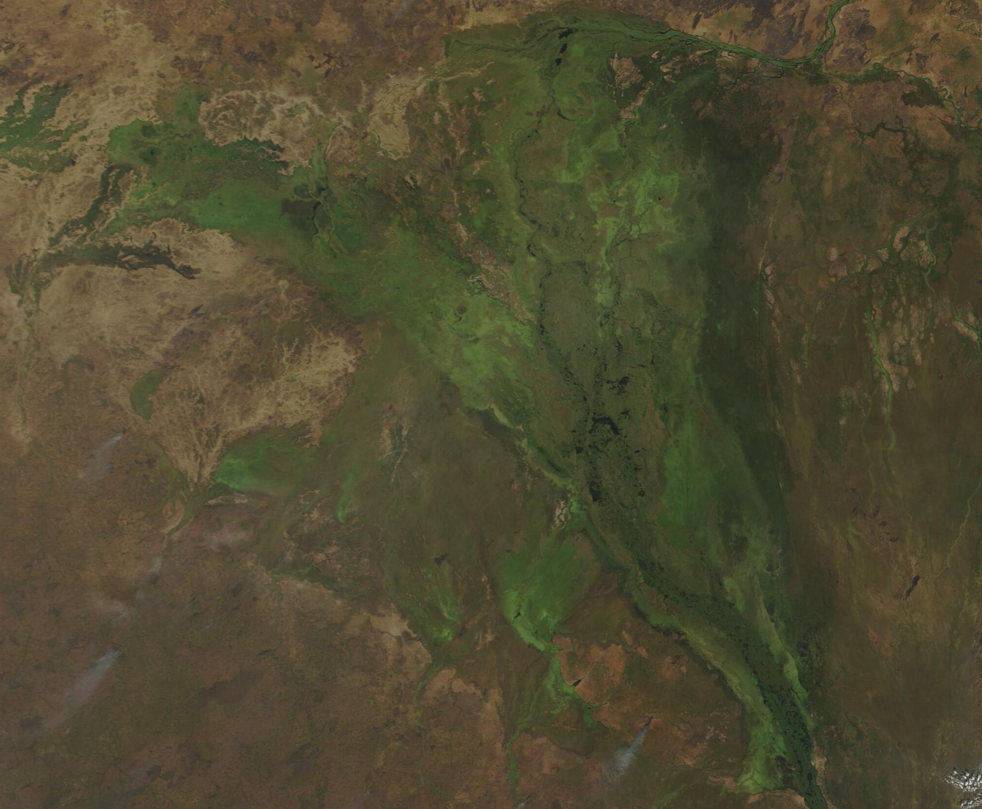
English: South Sudan has been called “one of Africa's wildlife Edens, a global biodiversity hotspot wedged between the continent's tropical jungles and dry, desolate deserts”. It is also a country torn by turmoil since at least 1870, when it was claimed as the colony of Equatoria by the British explorer Samuel Baker in the name of the Ottoman Khedive of Egypt. Decades later, Equatoria was combined with the colony of Sudan, to its north, shortly before Britain granted independence to the pair under the governance of Sudan in 1956. The knitting together of the two former colonies never worked well, and Sudan suffered many deadly and destructive civil wars until a peace agreement was reached in 2005. This gave South Sudan autonomy and, in 2011, independence. The struggle over governance of this beautiful land has continued, however, with government and rebel forces clashing until 2018. At that time, the opposing sides agreed to the formation of a transitional government—but the fulfilment of that promise has been slow in coming. More than 2.5 million civilians are estimated to have died in the conflicts since independence, and many have become refugees fleeing into the country’s central swamplands to try to survive, hidden in the remote recesses of floating mats of vegetation, after destruction of their homes.
On December 17, 2020, the Moderate Resolution Imaging Spectroradiometer (MODIS) acquired a true-color image of the swampy heartland of South Sudan. The rich green colors mark Al-Sudd, the dense wetlands that provides a home for about 400 bird and mammal species—and thousands of refugees. It also is the location of the spectacular annual migration of about 1.2 million antelope and gazelle. The size of the vast wetlands of Al-Sudd change with the seasons, shrinking in the dry season and expanding in the rainy season until, in December after rains subside, Al-Sudd reaches its largest expanse. This seasonal flux makes the size of the region difficult to measure with precision, but many estimate the boundaries at roughly 250 miles (400 km) long and 200 miles (320 km) wide. Al-Sudd is drained by the Mountain Nile (Al-Jabal) River, which is the headwater of the White Nile, in the center and the Al-Ghazal River in the west. These waters form innumerable swamps, lagoons, side channels and lakes filled with papyrus, aquatic grass, and water hyacinth. About 80 percent of the water entering through the rivers remain in Al-Sudd or are lost by evaporation. Recognized as one of the world’s largest freshwater marsh ecosystems and a vital link the ecology and biodiversity of northeastern Africa, efforts are in progress to preserve Al-Sudd. It is under heavy pressure, however, from deforestation, plans for development for agriculture or industry, lack of the government to enforce protective laws, and by the value of rich oil fields that underly the wetlands. |
||
| Date | Taken on 17 December 2020 | ||
| Source |
|
||
| Author | MODIS Land Rapid Response Team, NASA GSFC |
| This media is a product of the Terra mission Credit and attribution belongs to the mission team, if not already specified in the "author" row |
Licensing
[edit].jpg&action=edit§ion=2)
| This file is in the public domain in the United States because it was solely created by NASA. NASA copyright policy states that "NASA material is not protected by copyright unless noted". (See Template:PD-USGov, NASA copyright policy page or JPL Image Use Policy.) | ||
 |
Warnings:
|
File history
Click on a date/time to view the file as it appeared at that time.
| Date/Time | Thumbnail | Dimensions | User | Comment | |
|---|---|---|---|---|---|
| current | 19:21, 2 February 2024 | | 2,007 × 1,654 (252 KB) | OptimusPrimeBot (talk | contribs) | #Spacemedia - Upload of http://modis.gsfc.nasa.gov/gallery/images/image12282020_250m.jpg via Commons:Spacemedia |
You cannot overwrite this file.
File usage on Commons
There are no pages that use this file.
.jpg&oldid=848354521)