File:South Ribble UK locator map.svg
Jump to navigation
Jump to search

Size of this PNG preview of this SVG file: 513 × 600 pixels. Other resolutions: 205 × 240 pixels | 410 × 480 pixels | 657 × 768 pixels | 876 × 1,024 pixels | 1,751 × 2,048 pixels | 1,116 × 1,305 pixels.
Original file (SVG file, nominally 1,116 × 1,305 pixels, file size: 1.25 MB)
Captions
Captions
Add a one-line explanation of what this file represents
Summary
[edit]
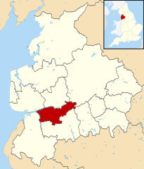
| Description | Map of Lancashire, with South Ribble highlighted. |
| Date | (UTC) |
| Source | |
| Author |
|
.svg)
Licensing
[edit]
I, the copyright holder of this work, hereby publish it under the following license:
This file is licensed under the Creative Commons Attribution-Share Alike 3.0 Unported license.
- You are free:
- to share – to copy, distribute and transmit the work
- to remix – to adapt the work
- Under the following conditions:
- attribution – You must give appropriate credit, provide a link to the license, and indicate if changes were made. You may do so in any reasonable manner, but not in any way that suggests the licensor endorses you or your use.
- share alike – If you remix, transform, or build upon the material, you must distribute your contributions under the same or compatible license as the original.
Original upload log
[edit]
This image is a derivative work of the following images:
- File:Lancashire_UK_district_map_(blank).svg licensed with Cc-by-sa-3.0
- 2010-08-22T08:12:37Z Nilfanion 1116x1305 (1312296 Bytes) +inset, water colour tweak
- 2010-07-16T23:41:49Z Nilfanion 1116x1305 (946712 Bytes) {{Information |Description=Map of [[w:Lancashire|Lancashire]], UK with districts shown. Equirectangular map projection on WGS 84 datum, with N/S stretched 165% Geographic limits: *West: 3.13W *East: 2.03W *North: 54.25N *So
File history
Click on a date/time to view the file as it appeared at that time.
| Date/Time | Thumbnail | Dimensions | User | Comment | |
|---|---|---|---|---|---|
| current | 10:49, 5 January 2012 | | 1,116 × 1,305 (1.25 MB) | Renly~commonswiki (talk | contribs) | == {{int:filedesc}} == {{Information |Description=Map of Lancashire, with South Ribble highlighted. |Source=*File:Lancashire UK district map (blank).svg |Date=2012-01-05 10:49 (UTC) |Author=*File:Lancashire UK district map (blank).svg: [[User: |
You cannot overwrite this file.
File usage on Commons
The following page uses this file:
File usage on other wikis
The following other wikis use this file:
- Usage on ca.wikipedia.org
- Usage on cy.wikipedia.org
- Usage on en.wikipedia.org
- Usage on es.wikipedia.org
- Usage on fr.wikipedia.org
- Usage on ja.wikipedia.org
- Usage on ko.wikipedia.org
- Usage on lt.wikipedia.org
- Usage on nl.wikipedia.org
- Usage on pl.wikipedia.org
- Usage on pt.wikipedia.org
- Usage on ro.wikipedia.org
- Usage on ru.wikipedia.org
- Usage on sv.wikipedia.org
- Usage on tr.wikipedia.org
- Usage on ur.wikipedia.org
- Usage on www.wikidata.org
- Usage on zh-min-nan.wikipedia.org