File:South Luconia Shoals f 12.jpg
Jump to navigation
Jump to search

Size of this preview: 800 × 453 pixels. Other resolutions: 320 × 181 pixels | 640 × 362 pixels | 1,000 × 566 pixels.
Original file (1,000 × 566 pixels, file size: 187 KB, MIME type: image/jpeg)
Captions
Captions
Add a one-line explanation of what this file represents
Summary
[edit]
| Description |
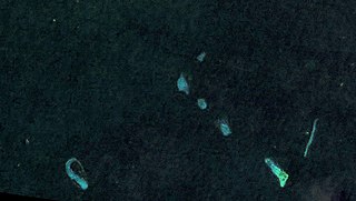
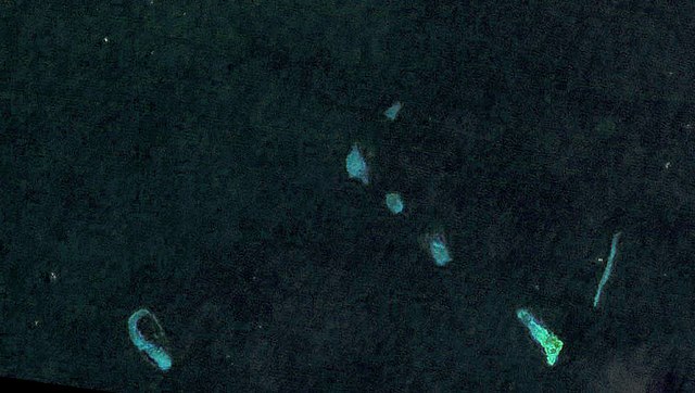
Deutsch: Landsat 7 Satellitenbild der südlichen Luconia-Untiefen (auch -Riffe, englisch South Luconia Shoals) im Südchinesische Meer südwestlich der Spratly-Inseln auf dem Festlandsockel vor dem malaysischen Bundesstaat Sarawak. Die Belichtung des Bilds wurde um ca. 12 Blendenstufen angehoben. Die Originalfarbe (RGB: 52,29,61) spielt ins Violette, daher wurde eine Farbüberlagerung (RGB:6,36,47) verwendet auf Basis der Farbe des Satelliten-Bilds von Bing Maps für diese Koordinaten 5°36′0.0″N 112°36′0.0″W / 5.6°N 112.6°W. English: Landsat 7 satellite image of the South Luconia Shoals in the South China Sea southwest of the Spratly Islands on the continental shelf in front of the Malaysian state of Sarawak. The exposure of the image has been increased by about 12 f-stops. The original color (RGB: 52,29,61) is purplish, therefore a color overlay was used which is based on the color (RGB:6,36,47) of the Satellite Image of Bing Maps for this coordinates 5°36′0.0″N 112°36′0.0″W / 5.6°N 112.6°W. |
| Date | |
| Source | https://web.archive.org/web/20120724041608/http://www.oceandots.com/pacific/luconia/ |
| Author | NASA |
Licensing
[edit]
| This file is in the public domain in the United States because it was solely created by NASA. NASA copyright policy states that "NASA material is not protected by copyright unless noted". (See Template:PD-USGov, NASA copyright policy page or JPL Image Use Policy.) | ||
 |
Warnings:
|
| Annotations | This image is annotated: View the annotations at Commons |
File history
Click on a date/time to view the file as it appeared at that time.
| Date/Time | Thumbnail | Dimensions | User | Comment | |
|---|---|---|---|---|---|
| current | 17:09, 18 May 2015 | | 1,000 × 566 (187 KB) | MagentaGreen (talk | contribs) | =={{int:filedesc}}== {{Information |description={{de|1=Landsat 7 Satellitenbild der südlichen Luconia-Untiefen (auch -Riffe, englisch South Luconia Shoals) im Südchinesische Meer südwestlich der Spratly-Inseln auf dem Festlandsockel vor dem malaysis... |
You cannot overwrite this file.
File usage on Commons
The following page uses this file:
File usage on other wikis
The following other wikis use this file:
- Usage on de.wikipedia.org
- Usage on en.wikipedia.org
- Usage on ja.wikipedia.org
- Usage on ms.wikipedia.org
- Usage on zh.wikipedia.org