File:South China Sea claims map.svg
Jump to navigation
Jump to search

Size of this PNG preview of this SVG file: 515 × 599 pixels. Other resolutions: 206 × 240 pixels | 413 × 480 pixels | 660 × 768 pixels | 880 × 1,024 pixels | 1,761 × 2,048 pixels | 1,134 × 1,319 pixels.
Original file (SVG file, nominally 1,134 × 1,319 pixels, file size: 1.9 MB)
Captions
Captions
Add a one-line explanation of what this file represents
Summary
[edit]
| Description |
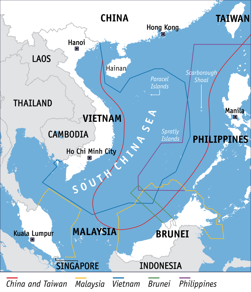
English: SVG version of the South China Sea claims map by Voice of America |
| Date | |
| Source | http://blogs.voanews.com/state-department-news/2012/07/31/challenging-beijing-in-the-south-china-sea/ |
| Author | Voice of America (vectorised by HueMan1) |
Licensing
[edit]
This media is in the public domain in the United States because it solely consists of material created and provided by Voice of America, the official external broadcasting service of the federal government of the United States.
View Terms of Use and Privacy Notice (copyright information). |
||
| This file has been identified as being free of known restrictions under copyright law, including all related and neighboring rights. | ||
File history
Click on a date/time to view the file as it appeared at that time.
| Date/Time | Thumbnail | Dimensions | User | Comment | |
|---|---|---|---|---|---|
| current | 13:05, 24 October 2021 | | 1,134 × 1,319 (1.9 MB) | HueMan1 (talk | contribs) | Fixed Hong Kong SAR |
| 09:18, 15 August 2021 |  | 1,134 × 1,319 (1.9 MB) | HueMan1 (talk | contribs) | minor fix | |
| 08:24, 15 August 2021 |  | 1,134 × 1,319 (1.9 MB) | HueMan1 (talk | contribs) | Uploaded own work with UploadWizard |
You cannot overwrite this file.
File usage on Commons
The following 4 pages use this file:
File usage on other wikis
The following other wikis use this file:
- Usage on am.wikipedia.org
- Usage on ar.wikipedia.org
- Usage on ast.wikipedia.org
- Usage on ca.wikipedia.org
- Mar de la Xina Meridional
- Illes del Mar de la Xina Meridional
- Conflicte territorial a la mar de la Xina meridional
- Iniciativa del Cinturó i Ruta de la Seda
- Sansha
- Illes Zhongsha
- Escull Scarborough
- Escull de Fiery Cross
- Illa Woody
- Gran Muralla de Sorra
- Escull Johnson del Sud
- Llista de reivindicacions territorials
- Usage on cs.wikipedia.org
- Usage on cs.wikinews.org
- Usage on de.wikipedia.org
- Usage on en.wikipedia.org
- People's Liberation Army Navy
- Hainan
- China–United States relations
- Timeline of Philippine history
- List of territorial disputes
- China–Indonesia relations
- China–Vietnam relations
- Spratly Islands dispute
- China–Philippines relations
- Quadrilateral Security Dialogue
- South China Sea Arbitration
- Hai Yang Shi You 981 standoff
- Great Wall of Sand
- Timeline of the South China Sea dispute
- Exclusive economic zone of Vietnam
- Exclusive economic zone of Malaysia
- Chinese salami slicing strategy
- Usage on es.wikipedia.org
- Usage on eu.wikipedia.org
- Usage on fa.wikipedia.org
View more global usage of this file.