File:South Arm panorama – Gros Morne, NL – (2018-07-21).jpg
Jump to navigation
Jump to search

Size of this preview: 799 × 243 pixels. Other resolutions: 320 × 97 pixels | 640 × 195 pixels | 1,024 × 312 pixels | 1,280 × 389 pixels | 2,560 × 779 pixels | 7,619 × 2,318 pixels.
Original file (7,619 × 2,318 pixels, file size: 13.67 MB, MIME type: image/jpeg)
Captions
Captions
Add a one-line explanation of what this file represents
Summary
[edit]| Description |
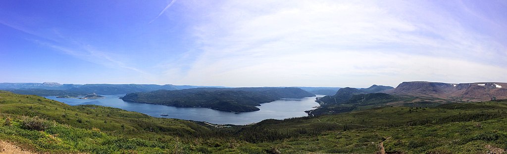
English: A panoramic shot of Gros Morne National Park centered on the South Arm of Bonne Bay, taken from a lookout above Woody Point. The Tablelands are visible on the right side of the photograph. |
||||||
| Location | Gros Morne National Park ← Newfoundland ← Newfoundland and Labrador ← Canada
|
||||||
| Designations |
|
||||||
| Date | Taken on 21 July 2018 | ||||||
| Source | Own work | ||||||
| Author | Ryan Sharpe | ||||||
| Permission (Reusing this file) |
|
||||||
| Attribution (required by the license) | Ryan Sharpe / Wikimedia Commons |

.jpg&action=edit§ion=1)
.jpg¶ms=049.495997_N_-057.944028_E_globe:Earth_type:camera__&language=en)
Licensing
[edit].jpg&action=edit§ion=2)
I, the copyright holder of this work, hereby publish it under the following license:
This file is licensed under the Creative Commons Attribution-Share Alike 4.0 International license.
Attribution: Ryan Sharpe / Wikimedia Commons
- You are free:
- to share – to copy, distribute and transmit the work
- to remix – to adapt the work
- Under the following conditions:
- attribution – You must give appropriate credit, provide a link to the license, and indicate if changes were made. You may do so in any reasonable manner, but not in any way that suggests the licensor endorses you or your use.
- share alike – If you remix, transform, or build upon the material, you must distribute your contributions under the same or compatible license as the original.
Notes
[edit].jpg&action=edit§ion=3)
This image was uploaded as part of Wiki Loves Earth 2019.
|
 |

|
Please do not overwrite this photograph with a modified image without first consulting with the author. The author would like to make any potential changes, even minor ones, only at his own source (often a RAW file), in order to preserve the quality of the image. If you think that changes are needed, please contact the author. |
File history
Click on a date/time to view the file as it appeared at that time.
| Date/Time | Thumbnail | Dimensions | User | Comment | |
|---|---|---|---|---|---|
| current | 00:52, 1 July 2019 | 7,619 × 2,318 (13.67 MB) | Sharper (talk | contribs) | User created page with UploadWizard |
You cannot overwrite this file.
File usage on Commons
The following page uses this file:
.jpg&oldid=700835312)