File:Soochow Planisphere (Detail 2).jpg
From Wikimedia Commons, the free media repository
Jump to navigation
Jump to search

Size of this preview: 587 × 599 pixels. Other resolutions: 235 × 240 pixels | 470 × 480 pixels | 752 × 768 pixels | 1,003 × 1,024 pixels | 2,007 × 2,048 pixels | 5,522 × 5,636 pixels.
Original file (5,522 × 5,636 pixels, file size: 6.86 MB, MIME type: image/jpeg)
File information
Structured data
Captions
Captions
Add a one-line explanation of what this file represents
Summary
[edit]| DescriptionSoochow Planisphere (Detail 2).jpg |
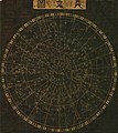
English: A rubbing of the "Soochow Planisphere" or "Suzhou Planisphere" (Tianwentu), a chart of the stars in the sky from the north celestial pole to 55° S. A central circle bounds the circumpolar constellations, outside of which the sky is divided into the 28 mansions (xiu) marking the longitude along the ecliptic of the moon through a sidereal month. Each 7 mansions are associated with a separate direction, color, and symbol (Verdant Dragon, Black Tortoise, White Tiger, Vermilion Phoenix) with various additional associations from the 5 element (wuxing) and fengshui systems. The overlapping outer circles are the celestial equator ("Red Road") and the ecliptic ("Yellow Road"). The band curving through the chart is the Milky Way ("River of Heaven"). The explanatory text states that 1565 stars were known to the Song-era astronomers but only 1440 are depicted. It also relates that the Great Absolute (Taiji) unfolded with the light and pure forming Heaven/Spirit, the heavy and impure forming Earth/Matter/Body, and the mingled pure and impure forming Man. This was presumably intended as a tutoring aid for Huang Shang as he educated the future Ningzong Emperor of the Song. Huang Shang drafted this map with several others at some point between 1190 and 1193, formally presenting them to either the Guangzong or Ningzong Emperor c. 1194. Wang Zhiyuan later engraved them on stone c. 1247 and this rubbing was made at some point during the 16th century, per carbon dating. The original stella is now at the Purple Mountain Observatory in Nanjing, with a copy at the Suzhou Confucian Museum. |
| Date | 16th c. rubbing of a c. 1247 engraving of a c. 1190 original map |
| Source | RareMaps.com, from a rubbing of an engraving of an original map. |
| Author | Huang Shang (map), Wang Zhiyuan (engraving) |
| Other versions |
|
Licensing
[edit]|
This is a faithful photographic reproduction of a two-dimensional, public domain work of art. The work of art itself is in the public domain for the following reason:
The official position taken by the Wikimedia Foundation is that "faithful reproductions of two-dimensional public domain works of art are public domain".
This photographic reproduction is therefore also considered to be in the public domain in the United States. In other jurisdictions, re-use of this content may be restricted; see Reuse of PD-Art photographs for details. | |||||
File history
Click on a date/time to view the file as it appeared at that time.
| Date/Time | Thumbnail | Dimensions | User | Comment | |
|---|---|---|---|---|---|
| current | 14:46, 28 March 2023 |  | 5,522 × 5,636 (6.86 MB) | LlywelynII (talk | contribs) | File:Soochow Planisphere.jpg cropped using CropTool. |
You cannot overwrite this file.
File usage on Commons
The following 2 pages use this file:

