File:Sokolka Plasy Objekt Zebnice evc 3.jpg
Jump to navigation
Jump to search

Size of this preview: 800 × 357 pixels. Other resolutions: 320 × 143 pixels | 640 × 285 pixels | 1,024 × 457 pixels | 1,906 × 850 pixels.
Original file (1,906 × 850 pixels, file size: 772 KB, MIME type: image/jpeg)
Captions
Captions
Add a one-line explanation of what this file represents
Summary
[edit]
| Description |
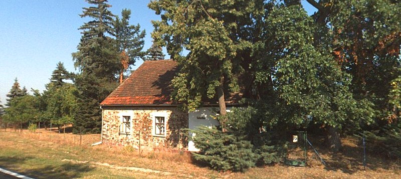
Čeština: Budova na samotě „Sokolka“ určená pro rodinnou rekreaci (na adrese Žebnice číslo evidenční 3). Jedná se o objekt s nápisem Sokolka, který leží u silnice I/27 mezi městem Plasy a obcí Hadačka, na katastrálním území vsi Žebnice při vrcholu bezejmenného návrší.
English: The building on the "Sokolka" secluded area intended for family recreation (at the address Žebnice registration number 3). It is a building with the inscription "Sokolka", which is located on the I/27 road between the town of Plasy and the village of Hadačka, in the cadastral territory of the village of Žebnice at the top of a nameless hill. |
| Date | |
| Source | Own work |
| Author | Mojmir Churavy |
| Permission (Reusing this file) |
I, the copyright holder of this work, hereby publish it under the following license: This file is licensed under the Creative Commons Attribution-Share Alike 4.0 International license.
|
| Camera location | | View this and other nearby images on: OpenStreetMap |
|---|
File history
Click on a date/time to view the file as it appeared at that time.
| Date/Time | Thumbnail | Dimensions | User | Comment | |
|---|---|---|---|---|---|
| current | 19:24, 2 April 2022 | | 1,906 × 850 (772 KB) | Mojmir Churavy (talk | contribs) | Uploaded own work with UploadWizard |
You cannot overwrite this file.
File usage on Commons
There are no pages that use this file.
File usage on other wikis
The following other wikis use this file:
- Usage on cs.wikipedia.org