File:Snow in the Caucasus Mountains (MODIS 2018-02-13).jpg

Original file (4,400 × 5,600 pixels, file size: 4.62 MB, MIME type: image/jpeg)
Captions
Captions
Summary
[edit].jpg&action=edit§ion=1)
| Description |
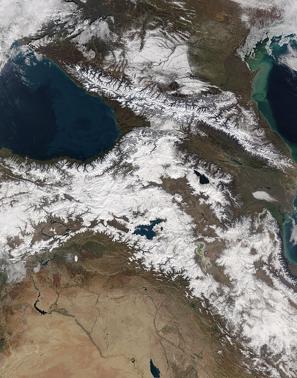
English: In the Caucasus Mountains, cold, dry air from Asia intersects with humid air from the Mediterranean, making precipitation amounts uneven across the range. You might remember the concerns prior to the 2014 Olympic Games about whether venues in Sochi and the western Caucasus would have enough snow for the sporting events.
Thanks to its proximity to the Black Sea, the western side of the range typically sees the heaviest snowfall. Humid air over the sea gets blown north and east and rises as it is forced upward by the mountains, which rise sharply just 100 kilometers (60 miles) from the shore. The air cools and the moisture drops out as snow. This part of the range receives about 240 centimeters (90 inches) of precipitation per year. Those totals contrast sharply with northern and eastern parts of the range—located in a rain shadow—where less than 40 centimeters (16 inches) of precipitation falls per year. On February 2, 2018, the Moderate Resolution Imaging Spectroradiometer (MODIS) on NASA’s Terra satellite acquired a natural-color image (above) of the snowcapped Caucasus range. Russia is visible in the top and right of the image, while Georgia, Azerbaijan, Armenia, and Turkey fill the bottom and left. Some of this snow could last well into spring and even summer. Snow that falls above elevations of 2500 meters in the western Caucasus can last for more than 200 days. That’s almost a month longer than the snow sticks around at similar elevations on the drier eastern range. |
||
| Date | Taken on 2 February 2018 | ||
| Source |
Snow in the Caucasus Mountains (direct link)
|
||
| Author | Jeff Schmaltz, MODIS Land Rapid Response Team, NASA GSFC |
| This media is a product of the Terra mission Credit and attribution belongs to the mission team, if not already specified in the "author" row |
Licensing
[edit].jpg&action=edit§ion=2)
| This file is in the public domain in the United States because it was solely created by NASA. NASA copyright policy states that "NASA material is not protected by copyright unless noted". (See Template:PD-USGov, NASA copyright policy page or JPL Image Use Policy.) | ||
 |
Warnings:
|
File history
Click on a date/time to view the file as it appeared at that time.
| Date/Time | Thumbnail | Dimensions | User | Comment | |
|---|---|---|---|---|---|
| current | 01:55, 17 February 2024 | | 4,400 × 5,600 (4.62 MB) | OptimusPrimeBot (talk | contribs) | #Spacemedia - Upload of http://modis.gsfc.nasa.gov/gallery/images/image02132018_250m.jpg via Commons:Spacemedia |
You cannot overwrite this file.
File usage on Commons
There are no pages that use this file.
.jpg&oldid=852927834)