File:Snow accumulation map for storm 03142017.png
Jump to navigation
Jump to search
No higher resolution available.
Snow_accumulation_map_for_storm_03142017.png (772 × 554 pixels, file size: 684 KB, MIME type: image/png)
Captions
Captions
Add a one-line explanation of what this file represents
Summary
[edit]
| Description |
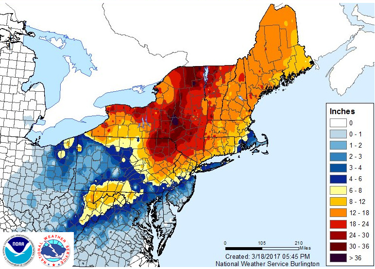
English: Snow total observed from march 14th to March 16th 2017 during a major snowstorm event. Highest amount is in Otsego County near Hartwick at 48.4 inches (123 cm). |
| Date | |
| Source | https://www.weather.gov/bgm/pastWinterMarch142017 |
| Author | US National Weather Service, Burlington Office. |
Licensing
[edit]
This image is in the public domain because it contains materials that originally came from the U.S. National Oceanic and Atmospheric Administration, taken or made as part of an employee's official duties.
|
File history
Click on a date/time to view the file as it appeared at that time.
| Date/Time | Thumbnail | Dimensions | User | Comment | |
|---|---|---|---|---|---|
| current | 03:49, 25 March 2017 | | 772 × 554 (684 KB) | Pierre cb (talk | contribs) | User created page with UploadWizard |
You cannot overwrite this file.
File usage on Commons
There are no pages that use this file.
File usage on other wikis
The following other wikis use this file:
- Usage on en.wikipedia.org
- Usage on fr.wikipedia.org