File:Snaily House - geograph.org.uk - 15269.jpg
Jump to navigation
Jump to search
No higher resolution available.
Snaily_House_-_geograph.org.uk_-_15269.jpg (640 × 425 pixels, file size: 201 KB, MIME type: image/jpeg)
Captions
Captions
Add a one-line explanation of what this file represents
Summary
[edit]
| Description |
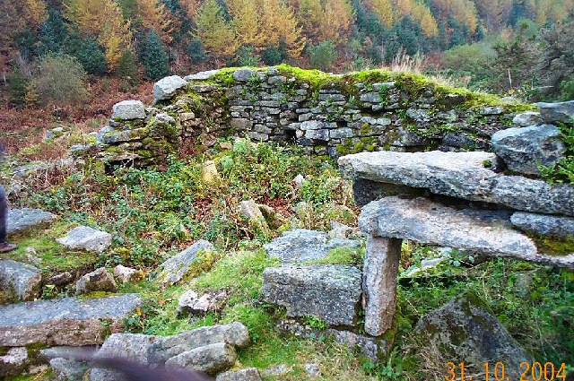
English: Snaily House. Snaily House is a ruined farmhouse that lies beside the East Dart just south of Bellever. The ruins lie rather hidden within the Whiteslades coniferous plantation which is all that is left of an old Dartmoor tenement from the 1700s. The story goes that the last inhabitants of the house were two spinsters who were rather fond of eating bottled, salted slugs and a few garden vegetables - hence the name Snaily. Local farmers suspected them of sheep stealing so we can imagine their surprise when the bottled secret slipped out. Apparently, the embarrassed ladies pined away and died leaving the house to fall into ruins. Of course, this is not quite true although Dartmoor does have a heritage of "diet supplement" tales that involve thick black slugs. |
| Date | |
| Source | From geograph.org.uk |
| Author | Richard Knights |
| Attribution (required by the license) | Richard Knights / Snaily House / |
| Object location | | View this and other nearby images on: OpenStreetMap |
|---|
_&language=en)
Licensing
[edit]

|
This image was taken from the Geograph project collection. See this photograph's page on the Geograph website for the photographer's contact details. The copyright on this image is owned by Richard Knights and is licensed for reuse under the Creative Commons Attribution-ShareAlike 2.0 license.
|
This file is licensed under the Creative Commons Attribution-Share Alike 2.0 Generic license.
Attribution: Richard Knights
- You are free:
- to share – to copy, distribute and transmit the work
- to remix – to adapt the work
- Under the following conditions:
- attribution – You must give appropriate credit, provide a link to the license, and indicate if changes were made. You may do so in any reasonable manner, but not in any way that suggests the licensor endorses you or your use.
- share alike – If you remix, transform, or build upon the material, you must distribute your contributions under the same or compatible license as the original.
File history
Click on a date/time to view the file as it appeared at that time.
| Date/Time | Thumbnail | Dimensions | User | Comment | |
|---|---|---|---|---|---|
| current | 05:03, 30 January 2010 | | 640 × 425 (201 KB) | GeographBot (talk | contribs) | == {{int:filedesc}} == {{Information |description={{en|1=Snaily House. Snaily House is a ruined farmhouse that lies beside the East Dart just south of Bellever. The ruins lie rather hidden within the Whiteslades coniferous plantation which is all that is |
You cannot overwrite this file.
File usage on Commons
There are no pages that use this file.