File:Smooth scouring rush, Equisetum laevigatum (39154875554).jpg

Original file (2,884 × 2,164 pixels, file size: 2.64 MB, MIME type: image/jpeg)
Captions
Captions
Summary
[edit].jpg&action=edit§ion=1)
| Description |
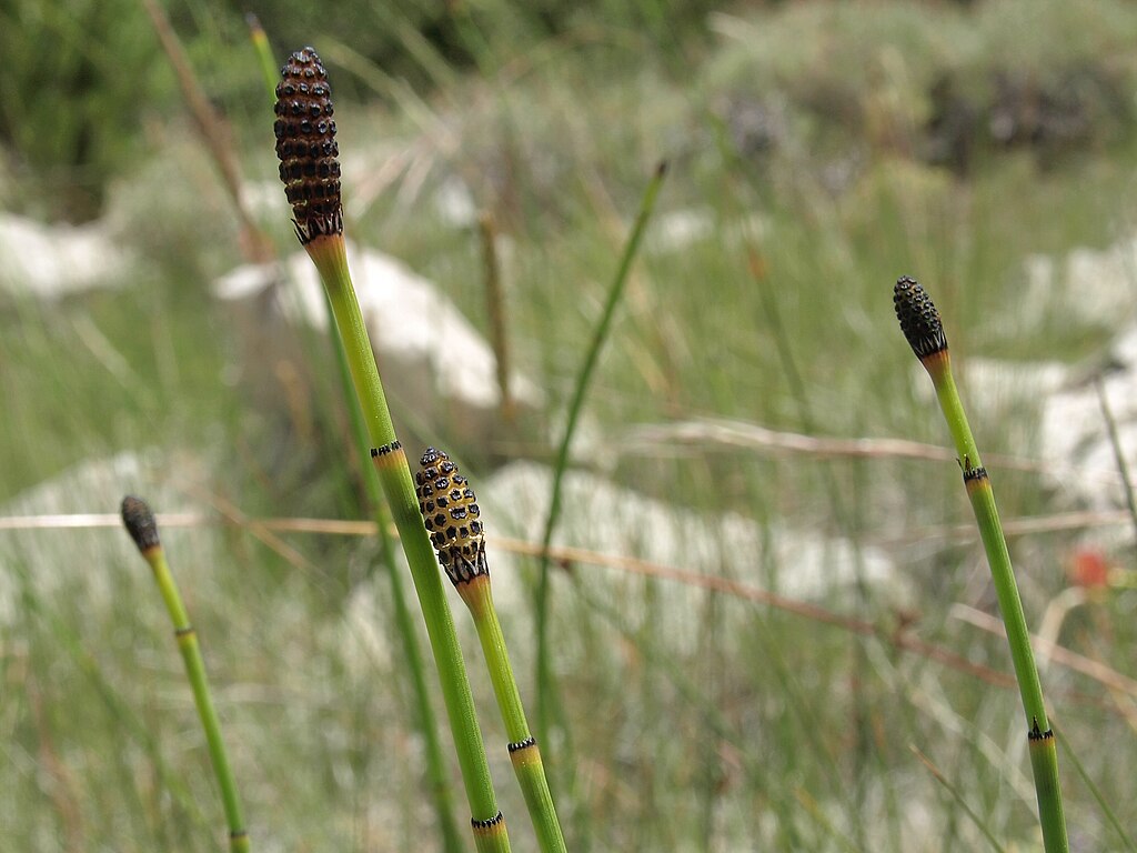
smooth scouring rush, Equisetum laevigatum, California, White Mountains, Cottonwood Basin, Poison Creek, Fishlake Valley drainage, elevation 3016 m (9895 ft). The 15 or so living species of Equisetum, the scouring rushes and horsetails, are the sole remaining members of a whole class of plants (Equisetopsida) that first appears in the fossil record during the late Paleozoic Era more than 300 million years ago, and came to dominate forest understories during the age of the dinosaurs. In contrast to the great age of its lineage, Equistetum laevigatum is thought to be one of the most recently diverged species in the family, having originated sometime during the last 2.5 million years of the Quaternary period. As is true of many spore-dispersed plants, smooth scouring rush is a widespread species, covering the entire western and north-central United States and adjacent southern Canada and northern Mexico, but apparently absent from New England, the Atlantic seaboard, and the southeastern U.S. It reaches as high as 3500 meters (11500 feet) elevation, and appears to share common ancestors with certain central and south American species. The scouring rushes get their name from the hard silica that accumulates in and on the epidermal cell walls of all Horsetail Family members, and that also helps make them so visible in the fossil record. And they work! -- I have quickly scrubbed clean many a camping pot with them. (Zoom in on the best-focused part of this image, and you can actually make out the silica coatings of individual cells.) |
| Date | |
| Source | smooth scouring rush, Equisetum laevigatum |
| Author | Jim Morefield from Nevada, USA |
| Camera location | | View this and other nearby images on: OpenStreetMap |
|---|
.jpg¶ms=037.515211_N_-118.172689_E_globe:Earth_type:camera_source:Flickr_&language=en)
Licensing
[edit].jpg&action=edit§ion=2)
- You are free:
- to share – to copy, distribute and transmit the work
- to remix – to adapt the work
- Under the following conditions:
- attribution – You must give appropriate credit, provide a link to the license, and indicate if changes were made. You may do so in any reasonable manner, but not in any way that suggests the licensor endorses you or your use.
- share alike – If you remix, transform, or build upon the material, you must distribute your contributions under the same or compatible license as the original.
| This image was originally posted to Flickr by Jim Morefield at https://flickr.com/photos/127605180@N04/39154875554 (archive). It was reviewed on 29 December 2019 by FlickreviewR 2 and was confirmed to be licensed under the terms of the cc-by-sa-2.0. |
File history
Click on a date/time to view the file as it appeared at that time.
| Date/Time | Thumbnail | Dimensions | User | Comment | |
|---|---|---|---|---|---|
| current | 03:27, 29 December 2019 | | 2,884 × 2,164 (2.64 MB) | Ser Amantio di Nicolao (talk | contribs) | Transferred from Flickr via #flickr2commons |
You cannot overwrite this file.
File usage on Commons
There are no pages that use this file.
.jpg&oldid=896348053)