File:Smith's New Map of London WDL526.png
Jump to navigation
Jump to search

Size of this preview: 800 × 524 pixels. Other resolutions: 320 × 210 pixels | 640 × 420 pixels | 1,024 × 671 pixels | 1,280 × 839 pixels | 1,562 × 1,024 pixels.
Original file (1,562 × 1,024 pixels, file size: 3.48 MB, MIME type: image/png)
Captions
Captions
Add a one-line explanation of what this file represents
Summary
[edit]
| Author |
Русский: Арчер, Д.
Français : Archer, J.
English: Archer, J.
中文:阿彻, J.
Português: Archer, J.
العربية: أرشير, ج.
Español: Archer, Johnson |
| Title |
Русский: Смит, новая карта Лондона
Français : Nouvelle carte de Londres selon Smith
English: Smith's New Map of London
中文:史密斯绘制的伦敦新地图
Português: Nova Mapa de Londres por Smith
العربية: خريطة سميث الجديدة للندن
Español: Nuevo mapa de Londres de Smith |
| Description |
Русский: К началу XIX века население Лондона достигло одного миллиона человек, и Лондон стал самым крупным городом в мире. К концу века население составляло уже около пяти миллионов человек. Стремительный рост таких городов, как Лондон, представлял собой новые трудности для составителей карт, поскольку возникала путаница относительно названий улиц, постоянно появлялись новые улицы и здания, в связи с чем возникала проблема согласования тригонометрического измерения улиц с их фактическими параметрами. В связи с ростом городов также значительно возрос спрос на карты — интерес к картам проявляли предприятия, страховые компании, правительственные учреждения и туристы. На данной карте, изданной в 1860 году компанией "Ч. Смит и сыновья", изображен Лондон, к тому времени значительно разросшийся от первоначальной центральной части города, расположенной вдоль реки Темза. Карта охватывает все возникшие пригороды города. Различные районы города обозначены разными цветами. Чарльз Смит торговал картами и глобусами. Он открыл свою компанию в начале XIX века по адресу Стрэнд, 172, и специализировался на картах и атласах Англии. Управление делами в компании Смита впоследствии перешло к его сыну, который руководил компанией вплоть доXX века.
Français : En 1800, la population de Londres avait atteint un million de personnes, ce qui en faisait la plus grande ville du monde. À la fin des années 1900, sa population frôlait les cinq millions d'habitants. La croissance rapide de villes comme Londres a contribué à faire apparaître de nouveaux défis pour des cartographes soucieux d'éviter les erreurs dans les noms des rues, tout en prenant en compte l'apparition régulière de nouvelles rues et bâtiments et le problème de l'alignement des mesures trigonométriques avec les mesures réelles. La croissance appelait également la création de nouvelles cartes, réclamées par les entreprises, les compagnies d'assurance, les agences gouvernementales, mais également les touristes. Cette carte, réalisée en 1860 par C. Smith & Son, montre un Londres qui a connu une forte expansion, se développant sur de nouveaux quartiers dans tous les directions autour des rives de la Tamise. (Les différentes sections de la ville sont identifiées par des codes couleur.) Charles Smith était un vendeur de cartes et de globes spécialisé dans les cartes et atlas de l'Angleterre, établi autour de 1800 au 172 Strand. Son entreprise fut reprise par son fils, et continua à bien se porter au cours du 20ème siècle.
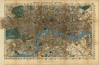
English: By 1800, the population of London had reached one million, making it the world’s largest city. By the end of the 1900s, its population was approaching five million. The rapid growth of cities such as London created new challenges for mapmakers, including confused street names, the constant appearance of new streets and buildings, and the problem of aligning the trigonometric measurement of streets with actual measurement. Growth also created new demand for maps -- from businesses, insurance companies, government agencies, and tourists. This 1860 map by C. Smith & Son shows a London much expanded from its original core along the Thames River to encompass new boroughs in all directions. The different divisions of the city are color-coded. Charles Smith was a map and globe seller, established around 1800 at 172 Strand, who specialized in maps and atlases of England. Smith’s business later was taken over by his son, and continued until well into the 20th century.
中文:1800 年,伦敦人口就已经达到 100 万,成为世界上最大的城市。 20 世纪末,该城市的人口达到了 500 万。 伦敦等城市的快速增长为绘图师带来了新的挑战,包括混乱的街道名称、不断出现新街道和建筑物以及街道三角测量与实际测量直接的调整问题。 城市的增长也创造了企业、保险公司、政府机构和旅游业对地图的新需求。 这幅由 C.Smith & Son 绘制的 1860 年地图 显示伦敦已经从原来沿泰晤士河的核心城区向各个方向扩张了新的城区。 该地图对该城市的不同区域采用不同的颜色进行了标注。 查尔斯·史密斯是一位地图和地球仪销售商,约于 1800 年成立公司,公司位于斯特兰德大道 172 号,专门经营英格兰地图和地图集。 史密斯的公司后来由其儿子接管,并一直经营到 20 世纪。
Português: Por volta de 1800, a população de Londres tinha atingido um milhão, tornando-a a maior cidade do mundo. Até ao final da década de 1900, sua população estava próximo dos cinco milhões. O rápido crescimento de cidades como Londres criou novos desafios para os cartógrafos, incluindo nomes de rua confusos, o constante aparecimento de novas ruas e prédios, bem como o problema de alinhar a medição trigonométrica das ruas com medição real. O crescimento criou também uma nova demanda de mapas -- de empresas, seguradoras, agências governamentais e turistas. Este mapa de 1860 por C. Smith & Son mostra uma Londres bastante ampliada a partir do seu núcleo original ao longo do Rio Tâmisa para agregar novos bairros em todas as direções. As diferentes divisões da cidade são codificadas por cores. Charles Smith era um vendedor de mapas e globos, estabelecido por volta de 1800 na Strand 172, o qual se especializou em mapas e atlas da Inglaterra. O negócio de Smith foi depois assumido por seu filho, e perdurou até o início do 20século século.
العربية: بحلول 1800، بلغ عدد سكان لندن المليون، مما جعلها أكبر مدينة في العالم. وفي نهاية العقد الأول من القرن العشرين، كان عدد سكانها يقارب خمسة ملايين نسمة. خلق النمو السريع للمدن الكبار مثل لندن تحديات جديدة في وجه رسامي الخرائط، بما في ذلك الفوضى في تسمية الشوارع، وظهور مستمر لشوارع ومبان جديدة، ومشكلة التوفيق بين القياسات المثلثاتية والقياسات الفعلية للشوارع. كما خلق النمو طلبا جديدا للخرائط -- من الشركات التجارية وشركات التأمين والمؤسسات الحكومية والسياح. تظهر هذه الخريطة التي وضِعت في 1860 من قبل تش. سميث وولده مدينة لندن وقد توسعت كثيرا من جوهرها الأصلي بمحاذاة نهر التيمز لتشمل أحياء جديدة في كافة الاتجاهات. وقد تم الإشارة إلى الأجزاء المختلفة من المدينة باستعمال الرموز اللونية. كان تشارلز سميث بائع خرائط مسطحة وكروية وأسس شركته نحو 1800 في 172 شارع ستراند، حيث تخصص في بيع خرائط وأطالس لإنجلترا. وفي وقت لاحق تولى ابنه زمام العمل واستمر به فيالقرن العشرين.
Español: En 1800, la población de Londres era de un millón de habitantes, lo que la convertía en la ciudad más grande del mundo. Hacia finales de 1900, su población era de casi cinco millones. El rápido crecimiento de ciudades como Londres presentaba nuevos retos a los cartógrafos, incluyendo la confusión de los nombres de las calles, la aparición continua de calles y edificios nuevos, y el problema de coordinar las medidas trigonométricas de las calles con las medidas reales. El crecimiento también supuso una nueva demanda de mapas por parte de negocios, compañías de seguros, agencias gubernamentales y turistas. Este mapa de C. Smith & Son muestra un Londres expandido mucho más allá de su centro original a lo largo del río Támesis, abarcando nuevos municipios en todas las direcciones. Las diferentes divisiones de la ciudad están señaladas con colores. Charles Smith era un vendedor de mapas y globos terráqueos, que se estableció en el 172 de Strand alrededor de 1800, y especializado en mapas y atlas de Inglaterra. Más tarde, su hijo se hizo cargo del negocio, que continuó hasta bien entrado el siglo XX. |
| Date | 1860 |
| Medium |
Русский: Карты
Français : Cartes
English: Maps
中文:地图
Português: Mapas
العربية: خرائط
Español: Mapas |
| Dimensions |
English: 1 map : color ; 36 x 63 centimeters |
| Collection |
Русский: Библиотека Конгресса
Français : Bibliothèque du Congrès
English: Library of Congress
中文:国会图书馆
Português: Biblioteca do Congresso
العربية: مكتبة الكونغرس
Español: Biblioteca del Congreso |
| Place of creation |
Русский: Лондон
Français : Londres
English: London
中文:伦敦
Português: Londres
العربية: لندن
Español: Londres |
| References | http://hdl.loc.gov/loc.wdl/dlc.526 |
| Source/Photographer |
|
Licensing
[edit]
|
This is a faithful photographic reproduction of a two-dimensional, public domain work of art. The work of art itself is in the public domain for the following reason:
The official position taken by the Wikimedia Foundation is that "faithful reproductions of two-dimensional public domain works of art are public domain".
This photographic reproduction is therefore also considered to be in the public domain in the United States. In other jurisdictions, re-use of this content may be restricted; see Reuse of PD-Art photographs for details. | ||||
File history
Click on a date/time to view the file as it appeared at that time.
| Date/Time | Thumbnail | Dimensions | User | Comment | |
|---|---|---|---|---|---|
| current | 19:18, 11 March 2014 | | 1,562 × 1,024 (3.48 MB) | Fæ (talk | contribs) | =={{int:filedesc}}== {{Artwork |artist = |author ={{ru|1=Арчер, Д.}} {{fr|1=Archer, J.}} {{en|1=Archer, J.}} {{zh|1=阿彻, J.}} {{pt|1=Archer, J.}} {{ar|1=أرشير, ج.}} {{es|1=Archer, J.}} |title ={{ru|1=Смит, новая карта Ло... |
You cannot overwrite this file.
File usage on Commons
The following page uses this file: